Nelsonville, Texas facts for kids
Quick facts for kids
Nelsonville, Texas
|
|
|---|---|

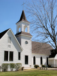
Nelsonville Brethren Church
|
|
| Country | United States |
| State | Texas |
| County | Austin |
| Elevation | 302 ft (92 m) |
| Time zone | UTC-6 (Central (CST)) |
| • Summer (DST) | UTC-5 (CDT) |
| Area code(s) | 979 |
| GNIS feature ID | 1363667 |
Nelsonville is a small, unincorporated community located in Austin County, Texas, United States. This means it's not an official city with its own local government. In 2000, about 110 people lived in Nelsonville. It is part of the larger Greater Houston area.
Contents
History of Nelsonville
Nelsonville began to be settled in the 1850s. One of the first settlers was Edward Daughtry in 1855. The community was later named after D. D. Nelson. He opened a store there after the American Civil War ended.
Around the same time, Isaac Lewis also ran several businesses. He had a store, a sawmill (for cutting wood), a gristmill (for grinding grain), and a cotton gin (for separating cotton fibers).
Early Settlers and Growth
Many of Nelsonville's first residents were immigrants from Bohemia. They arrived in the late 1860s and early 1870s. These families bought land grants and helped the community grow.
Nelsonville got its own post office in 1872. R. W. Thompson was the first postmaster, and he was also the town's doctor. The post office stayed open for many years but closed in 1909.
Nelsonville's Changing Population
By the early 1900s, Nelsonville had grown to 158 residents. It also had a church and several steam-powered mills and gins. The population went back down to 100 people in the early 1930s.
In 1936, there were six businesses in Nelsonville. However, most of these businesses closed soon after. Today, Nelsonville is mainly a farming community. In the early 1990s and again in 2000, about 110 people lived there. Many residents in the community have roots in the Czech Republic. A local church is a very important part of the community.
Nelsonville's Location and Surroundings
Nelsonville is located where two main roads meet: State Highway 159 (SH 159) and Farm to Market Road 2502 (FM 2502).
Nearby Towns and Roads
- The county seat, Bellville, is about 9.5 miles (15.3 km) to the east-southeast on SH 159.
- Industry is about 6.1 miles (9.8 km) to the west on the same highway.
- Bleiblerville is about 3.4 miles (5.5 km) northwest on FM 2502.
Another road, Farm to Market Road 2754 (FM 2754), crosses FM 2502 about 1.2 miles (1.9 km) northwest of Nelsonville. Other smaller roads, like Shupak Road and Skalak Road, also lead out from the community.
Local Landmarks
Between Nelsonville and Bellville, SH 159 is also known as Old Nelsonville Road. Between Nelsonville and Industry, it's called Fordtran Boulevard. The Nelsonville Brethren Church is a well-known building in the area. It is located on Nelsonville Church Road, which forms a triangle with SH 159 and FM 2502.
The Roesler House, a historic building in Nelsonville, is special. It is listed on the National Register of Historic Places. This means it's recognized as an important historical site.
Education in Nelsonville
Nelsonville had its own school way back in 1885. Today, students in the Nelsonville community attend schools that are part of the Bellville Independent School District.
Notable Person from Nelsonville
- Leo Meyer was a politician who came from Nelsonville. He married Margaret Lewis and later became the mayor of Bellville.
 | William M. Jackson |
 | Juan E. Gilbert |
 | Neil deGrasse Tyson |


