New Castle, Colorado facts for kids
Quick facts for kids
New Castle, Colorado
|
|
|---|---|

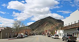
Main Street, looking towards the Grand Hogback
|
|
| Motto(s):
"Authentically Colorado"
|
|

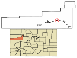
Location of New Castle in Garfield County, Colorado.
|
|
| Country | |
| State | |
| County | Garfield County |
| Incorporated (town) | March 27, 1890 |
| Government | |
| • Type | Home rule municipality |
| Area | |
| • Total | 2.61 sq mi (6.75 km2) |
| • Land | 2.52 sq mi (6.52 km2) |
| • Water | 0.09 sq mi (0.23 km2) |
| Elevation | 5,811 ft (1,771 m) |
| Population
(2020)
|
|
| • Total | 4,923 |
| • Density | 1,886/sq mi (729.3/km2) |
| Time zone | UTC-7 (Mountain (MST)) |
| • Summer (DST) | UTC-6 (MDT) |
| ZIP code |
81647
|
| Area code(s) | 970 |
| FIPS code | 08-53395 |
| GNIS feature ID | 2413042 |
The Town of New Castle is a special kind of town in Garfield County, Colorado, United States. It's called a "home rule municipality," which means it has more control over its own local government. In 2020, about 4,923 people lived in New Castle.
Contents
New Castle's Story
New Castle became an official town in 1888. Back then, its economy mostly relied on mining coal. This coal was very important for the silver-mining industry. It was used to heat up smelters to process silver.
A big event happened on February 18, 1896. A gas explosion in the Vulcan Mine killed 49 miners. This explosion also started a coal fire underground that was still burning in 2020! The Vulcan Mine reopened later. But it had more explosions on December 12, 1913 (killing 37 people) and November 4, 1918 (killing 3 people).
There are at least 25 coal fires still burning underground near the town. These fires usually stay hidden deep below the surface.
From 2000 to 2014, the number of people living in New Castle grew a lot. The population increased by 129%. This was much faster than the average growth in Colorado during the same time.
Where is New Castle?
New Castle is located on the north side of the Colorado River. It's just east of a place where the river cuts through a mountain range called the Grand Hogback.
Interstate 70 (I-70) is a major highway that runs near the town, following the river. You can get to New Castle from Exit 105 on I-70. If you drive east on I-70, it's about 12 miles (19 km) to Glenwood Springs, which is the main city of the county. Denver is about 169 miles (272 km) east. If you drive west, Grand Junction is about 74 miles (119 km) away.
U.S. Route 6 is another important road. It's the main street in New Castle. This road runs parallel to I-70 and is used for local traffic. US-6 joins I-70 about 5 miles (8 km) to the east and about 17 miles (27 km) to the west.
The town covers a total area of about 2.61 square miles (6.75 km²). Most of this area, about 2.52 square miles (6.52 km²), is land. A small part, about 0.09 square miles (0.23 km²), is water.
New Castle's People
| Historical population | |||
|---|---|---|---|
| Census | Pop. | %± | |
| 1890 | 311 | — | |
| 1900 | 431 | 38.6% | |
| 1910 | 493 | 14.4% | |
| 1920 | 447 | −9.3% | |
| 1930 | 470 | 5.1% | |
| 1940 | 484 | 3.0% | |
| 1950 | 483 | −0.2% | |
| 1960 | 447 | −7.5% | |
| 1970 | 499 | 11.6% | |
| 1980 | 563 | 12.8% | |
| 1990 | 679 | 20.6% | |
| 2000 | 1,984 | 192.2% | |
| 2010 | 4,518 | 127.7% | |
| 2020 | 4,923 | 9.0% | |
| U.S. Decennial Census | |||
The table above shows how the population of New Castle has changed over many years. You can see how the number of people living in the town has grown from 1890 to 2020.
Learning in New Castle
New Castle is part of the Garfield Re-2 School District. The town has several schools for students of different ages:
- Elk Creek Elementary School
- Kathryn Senor Elementary School
- Riverside Middle School
- Coal Ridge High School
See also
 In Spanish: New Castle (Colorado) para niños

