Grand Hogback facts for kids
Quick facts for kids Grand Hogback |
|
|---|---|

Part of the Grand Hogback near New Castle, Colorado.
|
|
| Highest point | |
| Elevation | 2,212 m (7,257 ft) |
| Geography | |
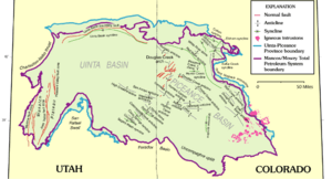
The Grand Hogback is a long, curved ridge in western Colorado. It stretches for about 70 miles (113 kilometers). Imagine a giant, wavy spine running across the land! This ridge starts near McClure Pass in Pitkin County. It then goes through Garfield County and ends near Meeker in Rio Blanco County.

The Grand Hogback is important because it helps mark a natural border. To its west is the Colorado Plateau, a large area of high flat lands. To its east are the Southern Rocky Mountains, with their tall, rugged peaks. The ridge itself looks like a series of jagged teeth. You can easily spot it on maps or from high up, like from an airplane. It's even visible from Interstate 70 as you drive by. The highest points of the ridge reach over 9,000 feet (2,700 meters) high.
River Gaps and Parks
Over a very long time, rivers have cut through the Grand Hogback. These cuts are called "gaps." The most famous gap was carved by the Colorado River near New Castle, Colorado. This shows how powerful rivers can be!
Other notable gaps include Harvey Gap and Rifle Gap. People have built dams in both of these gaps. These dams create large lakes, called reservoirs. These areas are now popular Colorado State Parks, where people can go fishing, boating, and enjoy nature.
How the Ridge Formed
The Grand Hogback is a special type of geological feature called a monocline. A monocline is like a giant fold in the Earth's rock layers. Imagine pushing a rug from one side; it creates a ripple or a step. That's similar to how a monocline forms.
This ridge is part of a rock layer known as the Mesaverde Formation. It was formed a very long time ago, towards the end of an event called the Laramide orogeny. This was a period when the Rocky Mountains were being uplifted. The Grand Hogback took shape during the middle to late Eocene epoch. This was roughly 34 to 56 million years ago!
 | Bayard Rustin |
 | Jeannette Carter |
 | Jeremiah A. Brown |


