McClure Pass facts for kids
Quick facts for kids McClure Pass |
|
|---|---|

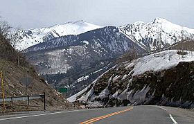
View north from the summit of McClure Pass towards the Elk Mountains near Marble
|
|
| Elevation | 8,793 ft (2,680 m) |
| Traversed by | State Highway 133 |
| Location | Gunnison / Pitkin counties, Colorado, U.S. |
| Range | Rocky Mountains |
| Coordinates | 39°07′44″N 107°17′02″W / 39.1288754°N 107.2839398°W |
| Topo map | Placita |
McClure Pass is a special spot in the Rocky Mountains of western Colorado, United States. It's a mountain pass, which means it's a low point or gap between mountains that makes it easier to travel across them. This pass sits right on the border between Pitkin and Gunnison counties.
The pass is located on the western side of the Elk Mountains. It reaches an elevation of 8,793 feet (about 2,680 meters) above sea level. McClure Pass connects the areas where the Crystal River starts (on the east side) with where the North Fork Gunnison River begins (on the west side). It was named after Thomas "Mack" McClure. In the late 1800s, he owned a large house at the eastern base of the pass. This house was a "stage stop" where travelers could rest, eat, and sleep during their journeys.
Traveling Through McClure Pass
State Highway 133 goes right over McClure Pass. This road is the most direct way to travel between the towns of Carbondale and Paonia. It connects the Roaring Fork Valley with the North Fork Valley.
Getting There and Back
McClure Pass isn't one of the highest mountain passes in Colorado. Because of its moderate elevation, it's usually open all year round. It only closes during very heavy snowstorms. The roads leading up to the pass are quite steep on both sides. They have an 8% grade, which means for every 100 feet you travel horizontally, you go up or down 8 feet. So, it's a bit of a climb!
 | Sharif Bey |
 | Hale Woodruff |
 | Richmond Barthé |
 | Purvis Young |


