New Castle, Kentucky facts for kids
Quick facts for kids
New Castle, Kentucky
|
|
|---|---|

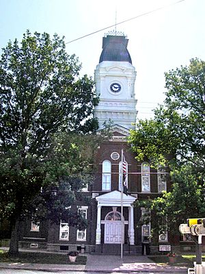
Henry County courthouse in New Castle, Kentucky
|
|

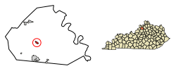
Location of New Castle in Henry County, Kentucky.
|
|
| Country | United States |
| State | Kentucky |
| County | Henry |
| Established | 1817 |
| Incorporated | 1851 |
| Area | |
| • Total | 0.41 sq mi (1.07 km2) |
| • Land | 0.41 sq mi (1.06 km2) |
| • Water | 0.00 sq mi (0.01 km2) |
| Elevation | 837 ft (255 m) |
| Population
(2020)
|
|
| • Total | 884 |
| • Density | 2,156.10/sq mi (832.94/km2) |
| Time zone | UTC-5 (Eastern (EST)) |
| • Summer (DST) | UTC-4 (EDT) |
| ZIP code |
40050
|
| Area code(s) | 502 |
| FIPS code | 21-55596 |
| GNIS feature ID | 2404359 |
New Castle is a small city in Henry County, Kentucky, United States. It is the main town and the seat of its county. This means it's where the county government offices are located. In 2020, about 884 people lived there. Before schools were integrated, African American students in New Castle attended the New Castle Colored School.
Contents
History of New Castle
New Castle officially became a city in 1817. This means it was given the legal right to govern itself.
The Odd Fellows Lodge
A special group called the District Grand Lodge No. 19 of the Grand United Order of Odd Fellows was located in New Castle. This was a fraternal organization, like a club, for African Americans. Its purpose was to help members and their families.
The group's local branch, Washington Lodge #1513, started in New Castle in 1872. It was founded by people who had been slaves. There is a historical marker near their building that tells the story of this important group.
Geography and Location
New Castle is located in the southwestern part of Henry County.
Roads and Travel
U.S. Route 421 runs through New Castle, following Main Street.
- If you go north on Route 421, you will reach Campbellsburg in about 7 miles (11 km).
- If you go southeast, you can get to Frankfort, the capital of Kentucky, which is about 29 miles (47 km) away.
- The larger city of Louisville is about 38 miles (61 km) to the southwest. You can get there by taking Kentucky Route 146 and then Interstate 71.
Land and Water
New Castle covers a total area of about 0.41 square miles (1.1 square kilometers). Most of this area is land. Only a very small part, about 0.004 square miles (0.01 square kilometers), is water.
Population Information
The population of New Castle has changed over the years. Here is a look at how many people have lived there during different census counts:
| Historical population | |||
|---|---|---|---|
| Census | Pop. | %± | |
| 1830 | 538 | — | |
| 1840 | 528 | −1.9% | |
| 1860 | 519 | — | |
| 1870 | 670 | 29.1% | |
| 1880 | 500 | −25.4% | |
| 1890 | 485 | −3.0% | |
| 1900 | 462 | −4.7% | |
| 1910 | 468 | 1.3% | |
| 1920 | 397 | −15.2% | |
| 1930 | 447 | 12.6% | |
| 1940 | 487 | 8.9% | |
| 1950 | 631 | 29.6% | |
| 1960 | 699 | 10.8% | |
| 1970 | 755 | 8.0% | |
| 1980 | 832 | 10.2% | |
| 1990 | 893 | 7.3% | |
| 2000 | 919 | 2.9% | |
| 2010 | 912 | −0.8% | |
| 2020 | 884 | −3.1% | |
| U.S. Decennial Census | |||
In 2000, there were 919 people living in New Castle. Most of the people living in the city were White (92.60%). About 5.77% were Black or African American. A small number of people were from other racial backgrounds.
Culture and Local Attractions
New Castle has some interesting historical places.
Samuel Hieatt House
One notable building is the Samuel Hieatt House. It was built in 1850. This house was added to the National Register of Historic Places in 1982. This means it is recognized as an important historical site worth preserving.
See also
 In Spanish: New Castle (Kentucky) para niños
 | Lonnie Johnson |
 | Granville Woods |
 | Lewis Howard Latimer |
 | James West |

