Raymer, Colorado facts for kids
Quick facts for kids
Town of Raymer, Colorado
|
|
|---|---|

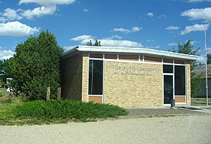
The New Raymer Post Office in the Town of Raymer, Colorado
|
|

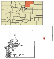
Location of Raymer (New Raymer) in Weld County, Colorado.
|
|
| Country | |
| State | |
| County | Weld County |
| Incorporated | 1919 |
| Government | |
| • Type | Statutory Town |
| Area | |
| • Total | 0.78 sq mi (2.03 km2) |
| • Land | 0.78 sq mi (2.03 km2) |
| • Water | 0.00 sq mi (0.00 km2) 0.0% |
| Elevation | 4,777 ft (1,456 m) |
| Population
(2020)
|
|
| • Total | 110 |
| • Density | 141/sq mi (54.2/km2) |
| Time zone | UTC-7 (MST) |
| • Summer (DST) | UTC-6 (MDT) |
| ZIP code |
New Raymer 80742
|
| Area code(s) | 970 |
| FIPS code | 08-63045 |
| GNIS feature ID | 0182778 |
The Town of Raymer is a small community in Weld County, Colorado, United States. It's a special type of town called a Statutory Town, which means it has its own local government. In 2020, about 110 people lived there.
This town actually has two official names:
- Raymer is the legal name for the town's government.
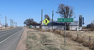
- New Raymer is the name used by the United States Postal Service for mail delivery.
Because of this, you might see either name on maps or in official lists.
History of Raymer
The story of Raymer began in 1888. A railroad company, the Chicago, Burlington and Quincy Railroad, planned and marked out the town. They named it after George Raymer, who was an assistant chief engineer for the railroad.
The first post office in Raymer opened on June 27, 1888. For a while, the town grew and did well. However, over time, families started to move away, and the post office closed on May 14, 1895.
But Raymer got a second chance! In 1909, the town was planned out again. On November 13, 1909, a new post office opened. To make sure people didn't confuse it with the old one, it was called New Raymer. Then, in 1919, the town officially became an incorporated town under its original name, the Town of Raymer. This meant it had its own local government.
Even today, the State of Colorado calls it Raymer, but the United States Postal Service still uses New Raymer (with ZIP code 80742) for mail.
Geography of Raymer
Raymer (also known as New Raymer) is located in a specific spot on Earth. Its coordinates are 40 degrees, 36 minutes, 31 seconds North and 103 degrees, 50 minutes, 35 seconds West. These numbers help pinpoint its exact location on a map.
The town covers a total area of about 0.78 square miles (2.03 square kilometers). All of this area is land, meaning there are no lakes or large rivers within the town limits.
Climate in Raymer
Raymer has a type of weather called a cold semi-arid climate. This means it's generally dry, but not as dry as a desert, and it can get quite cold, especially in winter.
The hottest temperature ever recorded in Raymer was 104°F (40°C). This happened on June 26, 2012, June 27, 2012, and July 17, 2006. The coldest temperature ever recorded was a very chilly -31°F (-35°C) on December 22, 1990.
Population of Raymer
| Historical population | |||
|---|---|---|---|
| Census | Pop. | %± | |
| 1920 | 267 | — | |
| 1930 | 254 | −4.9% | |
| 1940 | 169 | −33.5% | |
| 1950 | 130 | −23.1% | |
| 1960 | 91 | −30.0% | |
| 1970 | 68 | −25.3% | |
| 1980 | 80 | 17.6% | |
| 1990 | 98 | 22.5% | |
| 2000 | 91 | −7.1% | |
| 2010 | 96 | 5.5% | |
| 2020 | 110 | 14.6% | |
Demographics is a word that describes the different groups of people living in a place. It helps us understand how many people live there and how the population has changed over time. The table above shows how the number of people living in Raymer has changed since 1920. You can see that the population has gone up and down over the years. In 2020, 110 people called Raymer home.
See also
 In Spanish: Raymer para niños


