Newport Bay (Wales) facts for kids
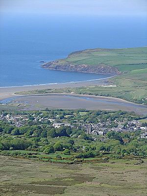
Newport Bay (in Welsh: Bae Trefdraeth) is a beautiful bay located on the northern coast of Pembrokeshire, Wales. This special area is part of the amazing Pembrokeshire Coast National Park. Newport Bay is one of many smaller bays found within the much larger Cardigan Bay.
The bay stretches for about two miles. It goes from a place called Dinas Island (which is actually a peninsula, meaning it's almost an island) all the way to the headland of Pen-y-bâl in the east. The charming town of Newport looks over the bay, and the River Nevern flows right into it.
Contents
Discovering Newport Bay's Features
Newport Bay has many interesting natural features and historical spots. Along its southern shore, you'll find smaller inlets. These are like tiny coves formed by small streams flowing into the bay.
Newport Sands and the River Nevern
In the southeast part of the bay, there's a wide sandy beach called Newport Sands. This beach stretches across the mouth of the River Nevern estuary. An estuary is where a river meets the sea, mixing fresh and salt water. The Welsh name for the River Nevern is Afon Nyfer.
Waterfalls, Caves, and Old Buildings
If you look to the north, you might spot navigation beacons on a hill. These used to help ships find their way. Nearby, there's a lovely waterfall called Pen Pistyll. Here, a stream drops about 15 meters (around 50 feet) down to the beach.
At the northern end of Newport Sands, you can explore some interesting caves. You'll also see old lime kilns on both sides of the river estuary. These kilns were once used to heat limestone to make lime, which was important for farming and building. In the early 1900s, there was even a lifeboat station on a beach called The Cwm, west of Parrog. It's now a private home.
The Pembrokeshire Coast Path
The famous Pembrokeshire Coast Path runs all around Newport Bay. This path is part of the even longer Wales Coast Path. When the path reaches the River Nevern estuary, it takes a short detour inland. This allows walkers to cross the river using the lowest road bridge.
Towns and Villages Near Newport Bay
There are a few settlements located close to Newport Bay. Each has its own unique character.
Newport Town and Parrog
Just south of the River Nevern estuary is the town of Newport. It's a lovely town that overlooks the bay. Close to Newport is an ancient port area called Parrog. While it's not used much as a port today, it still has a lot of history.
Cwm-yr-Eglwys Hamlet
At the southwest corner of Newport Bay, you'll find the small hamlet of Cwm-yr-Eglwys. A hamlet is a very small village. It's a quiet and scenic spot right by the water.
Activities and Clubs at the Bay
Newport Bay offers some great opportunities for outdoor activities.
Golf and Sailing
The Newport Links Golf Club is located on the eastern side of the bay. It stretches across the sand dunes, offering a unique golfing experience. Near the mouth of the river, there's also a sailing club. This is a popular spot for people who enjoy sailing and other water sports.
 | Sharif Bey |
 | Hale Woodruff |
 | Richmond Barthé |
 | Purvis Young |


