Newport Pagnell Canal facts for kids
Quick facts for kids Newport Pagnall Canal |
|
|---|---|

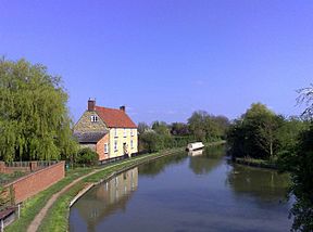
The Wharf at Great Linford. The canal passed between the building and the wall on the left.
|
|
| Specifications | |
| Length | 1.25 miles (2.01 km) |
| Maximum boat length | 72 ft 0 in (21.95 m) |
| Maximum boat beam | 7 ft 0 in (2.13 m) |
| Locks | 7 |
| Status | Used for railway (now dismantled) |
| History | |
| Date of act | 1814 |
| Date of first use | 1817 |
| Date closed | 1864 |
| Geography | |
| Start point | Great Linford |
| End point | Newport Pagnell |
| Connects to | Grand Union Canal |
The Newport Pagnell Canal was a short waterway in Buckinghamshire, England. It was only about 2 kilometers (1.25 miles) long. This canal connected the town of Newport Pagnell to the larger Grand Union Canal (then called the Grand Junction Canal) at Great Linford. Boats used seven locks to travel along its path. The canal was built after a special law was passed in 1814 and likely opened in 1817. It operated for many years but eventually closed in 1864. Part of its route was later used to build a railway line.
Contents
Building the Canal: A Look Back
Canals were very important for moving goods in the past. In 1791, plans began for the Grand Junction Canal. This big canal would link Braunston to London. Many other canal ideas popped up soon after, hoping to connect to this main route.
Early Ideas for a Branch Canal
In 1793, people first suggested building a branch canal to Newport Pagnell. A surveyor named James Barnes checked the route. However, the main Grand Junction Canal committee decided not to build this branch. They thought it wasn't a good idea.
Making the Canal a Reality
Years later, in 1813, people in Newport Pagnell met again. They wanted a canal or even a railway. The Grand Junction Canal still refused to build the branch. So, the local people decided to build it themselves. They needed a special law, called an Act of Parliament, to do this. This law was approved in June 1814.
Work on the canal started in early 1815. It took two years to build. The canal opened in early 1817. It was about 2 kilometers (1.25 miles) long. The land dropped about 15.5 meters (50.75 feet) from Great Linford to Newport Pagnell. This is why seven locks were needed. Locks help boats move up or down hills of water. The locks were 22 meters (72 feet) long and 2.1 meters (7 feet) wide.
What the Canal Carried and How It Made Money
Building the canal cost about £14,200. The main goods carried were coal. This coal came from places like Shipley and Moira. About 7,500 tons of coal were moved each year. Other goods included lime, manure, and bricks.
The canal charged high fees, called tolls. For example, it cost 9 pence (about 4p) to use the whole canal. This was much more than other nearby canals charged. Even with high tolls, the canal made a profit. It paid out money to its owners every year. In 1845, the canal carried the most goods ever: 14,887 tons.
Thinking About Expanding the Canal
When the canal was being planned, people hoped to make it longer. They thought about extending it to Olney. They also wanted to connect it to the River Great Ouse near Bedford.
Plans That Didn't Happen
After the canal opened, a new survey was done. It suggested a canal for 20-ton boats. This canal would go from Newport Pagnell to St Neots, joining the Ouse. There was also an idea for a branch to Kimbolton. But none of these plans ever happened. The idea of linking to the upper Ouse came up again in 1838, but again, nothing was built.
Why the Canal Closed: The Rise of Railways
In 1845, a railway company, the London and North Western Railway, tried to buy the canal. The canal owners said no. But in 1862, the canal was sold to the Newport Pagnell Railway for £9,000. Other canal companies and coal mines were against this sale.
The End of the Canal Era
A new law was passed in 1863 to allow the railway to take over. The Newport Pagnell Canal officially closed in August 1864. The railway then built its tracks over parts of the old canal route. In Newport Pagnell, the railway even used some of the canal's old warehouses.
Where the Canal Ran: Its Route Today
The canal started near Lindford Wharf Bridge. It went mostly straight, heading east towards Newport Pagnell. The locks were the main engineering parts. There were not many roads crossing the canal's path back then.
Traces of the Past
Even today, only a few routes cross where the canal used to be. The M1 motorway crosses it, but that was built much later. The two lock areas just below Great Linford Wharf were shown on maps until 1968. After that, they disappeared.
The spot where the canal joined the Grand Junction Canal is still there. It's marked by a large turning area for boats. This main canal is now part of the Grand Union Canal. A pub near the canal's entrance was popular with boatmen. It closed in the 1960s. During recent building work, part of the old canal wall was found at the railway station site in Newport Pagnell.
 | Lonnie Johnson |
 | Granville Woods |
 | Lewis Howard Latimer |
 | James West |

