Newtownabbey Borough Council facts for kids
Quick facts for kids Newtownabbey Borough |
|
|---|---|
 |
|
| Area | 151 km2 (58 sq mi) Ranked 22nd of 26 |
| District HQ | Newtownabbey |
| Catholic | 22.6% |
| Protestant | 67.8% |
| Country | Northern Ireland |
| Sovereign state | United Kingdom |
| EU Parliament | Northern Ireland |
| Councillors |
|
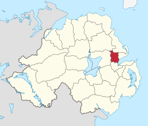
The Newtownabbey Borough Council was a local government body in County Antrim, Northern Ireland. It was located on the northern shore of Belfast Lough, just north of Belfast. This council was responsible for managing local services and making decisions for the people living in the Newtownabbey area.
In April 2015, the Newtownabbey Borough Council joined with the Antrim Borough Council. They merged to create a new, larger council called the Antrim and Newtownabbey Borough Council. This change was part of a big plan to update local government in Northern Ireland.
Contents
History of Newtownabbey
Newtownabbey was officially created in 1958. It was formed from several large towns and residential areas, along with traditional farming communities. The main industries in the area included electronics, software, and telecommunications. Farming was also very important.
The main offices for the council were at Mossley Mill in Newtownabbey. Important towns within the area included Ballyclare and Glengormley. The University of Ulster at Jordanstown was also located in the area that the council covered.
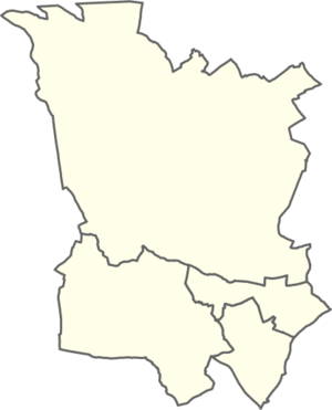
The Newtownabbey Borough Council area was divided into four special zones for elections. These were called Antrim Line, Macedon, University, and Ballyclare. In the 2011 elections, 25 members were chosen to be councillors. These councillors came from different political parties. Each year, usually in June, the council would elect a Mayor. The Mayor was the most important citizen of the Borough.
For elections to the Westminster Parliament (the main UK Parliament), the Newtownabbey area was part of three different voting areas. These were the East Antrim, South Antrim, and North Belfast constituencies.
As mentioned, in May 2015, Newtownabbey Borough Council merged with Antrim Borough Council. They formed the new Antrim and Newtownabbey District Council.
Council Elections and Changes
When the council was first set up for the 1973 local elections, it had four electoral areas. These were simply named A, B, C, and D. They elected a total of 21 councillors.
For the 1985 local elections, the number of electoral areas grew to five. These new areas were Manse Road, Doagh Road, Shore Road, Antrim Line, and Ballyclare. Each of these areas elected five councillors.
There were more changes to the boundaries for the 1993 local elections. The Doagh Road area, which included Rathcoole, had its number of wards reduced. It then gained the Whiteabbey and Cloughfern wards from the Shore Road district. This created a new area called Macedon. The Antrim Line district also gained new wards. The remaining parts of the Manse Road and Shore Road districts were combined to form the University district.
Summary of Seats Won (1973–2011)
This table shows how many seats different political parties won in the Newtownabbey Borough Council elections over the years. It helps us see how the support for different parties changed.
| 1973 | 1977 | 1981 | 1985 | 1989 | 1993 | 1997 | 2001 | 2005 | 2011 | |
|---|---|---|---|---|---|---|---|---|---|---|
| Ulster Unionist Party (UUP) | 9 | 8 | 9 | 10 | 11 | 10 | 10 | 9 | 6 | 5 |
| Alliance (APNI) | 3 | 6 | 3 | 2 | 4 | 4 | 3 | 1 | 2 | 5 |
| Democratic Unionist Party (DUP) | 3 | 4 | 5 | 9 | 6 | 5 | 2 | 8 | 12 | 12 |
| Independent Unionist (IU) | 3 | 3 | 2 | 2 | 4 | 3 | 1 | |||
| Loyalist (Loy) | 2 | 1 | ||||||||
| Labour† | 1 | 1 | 1 | 1 | 1 | 1 | 2 | 1 | ||
| Unionist Party of Northern Ireland (UPNI) | 1 | |||||||||
| Independent (Ind) | 1 | 1 | ||||||||
| Social Democratic and Labour Party (SDLP) | 1 | 1 | 1 | 2 | 1 | 1 | ||||
| Newtownabbey Ratepayers' Association (NRA) | 2 | 1 | 1 | |||||||
| Ulster Democratic Party (UDP) | 1 | 1 | ||||||||
| Progressive Unionist Party (PUP) | 1 | |||||||||
| Sinn Féin (SF) | 1 | 1 | 2 | |||||||
| United Unionist Coalition (UUC) | 1 | 1 |
† Labour results include those for Robert Kidd and Mark Langhammer, who ran under various Labour-related names.
Mayors of Newtownabbey
The Mayor was the head of the council and represented the borough. Here is a list of the people who served as Mayor of Newtownabbey Borough Council:
- 1977 – 78: Sidney Cameron, Ulster Unionist Party
- 1978 – 80: Arthur Templeton, Ulster Unionist Party
- 1980 – 81: J. Smith, Democratic Unionist Party
- 1981 – 82: C. W. Stringer, Ulster Unionist Party
- 1982 – 83: Clifford Forsythe, Ulster Unionist Party
- 1983 – 86: Leslie Caul, Ulster Unionist Party
- 1986 – 87: George Herron, Independent Unionist
- 1987 – 89: J. Smith, Democratic Unionist Party
- 1989 – 90: George Herron, Independent Unionist
- 1990 – 91: Fraser Agnew, Ulster Unionist Party
- 1991 – 92: Ken Robinson, Ulster Unionist Party
- 1992 – 93: Arthur Templeton, Independent Unionist
- 1993 – 94: Arthur Kell, Ulster Unionist Party
- 1994 – 95: J. Robinson, Ulster Unionist Party
- 1995 – 96: Andrew Beattie, Ulster Unionist Party
- 1996 – 97: Billy Snoddy, Democratic Unionist Party
- 1997 – 99: Edward Crilly, Ulster Unionist Party
- 1999 – 00: Jim Bingham, Ulster Unionist Party
- 2000 – 02: Vera McWilliam, Ulster Unionist Party
- 2002 – 04: Paul Girvan, Democratic Unionist Party
- 2004 – 05: Ted Turkington, Ulster Unionist Party
- 2005 – 06: Billy DeCourcy, Democratic Unionist Party
- 2006 – 07: Lynn Frazer, Alliance Party of Northern Ireland
- 2007 – 08: Nigel Hamilton, Democratic Unionist Party
- 2008 – 09: Victor Robinson, Democratic Unionist Party
- 2009 – 10: John Scott, Ulster Unionist Party
- 2010 – 11: Paula Bradley, Democratic Unionist Party
- 2011 – 12: Billy Webb, Alliance Party of Northern Ireland
- 2012 – 13: Victor Robinson, Democratic Unionist Party
- 2013 – 14: Fraser Agnew, Ulster Unionist Party
- 2014 – 15: Thomas Hogg, Democratic Unionist Party
Changes in Public Administration
There was a big plan called the "Review of Public Administration" (RPA). This plan aimed to change how local government worked in Northern Ireland. Under this plan, Newtownabbey Borough was supposed to merge with Antrim Borough. The goal was to create one larger council for a bigger area.
Originally, the next local elections were planned for May 2009. However, the Secretary of State for Northern Ireland announced in April 2008 that these elections would be put off. They decided to wait until the new, larger councils were ready in 2011. Finally, on April 1, 2015, the new Antrim and Newtownabbey Borough Council officially took over responsibility for the area.
Population Information
According to the 2011 Northern Ireland census, the area that used to be covered by Newtownabbey Borough Council had a population of 85,139 people.
 | Bayard Rustin |
 | Jeannette Carter |
 | Jeremiah A. Brown |


