
Nimmitabel facts for kids
Quick facts for kids NimmitabelNew South Wales |
|||||||||
|---|---|---|---|---|---|---|---|---|---|
.jpg)
The main street of Nimmitabel, 2010
|
|||||||||

Nimmitabel
Location in New South Wales
|
|||||||||
| Population | 324 (2021 census) | ||||||||
| Postcode(s) | 2631 | ||||||||
| Elevation | 1,075 m (3,527 ft) | ||||||||
| Location | |||||||||
| LGA(s) | Snowy Monaro Regional Council | ||||||||
| State electorate(s) | Monaro | ||||||||
| Federal Division(s) | Eden-Monaro | ||||||||
|
|||||||||
Nimmitabel is a small and interesting town. It is located in the Monaro region of southeast New South Wales, Australia. This town is part of the Snowy Monaro Regional Council area. In 2021 census, about 324 people lived in Nimmitabel.
Contents
What Does Nimmitabel Mean?
The name Nimmitabel comes from the local Aboriginal language. It means "the place where many waters start or divide." Over the years, people spelled the town's name in many different ways. Some of these spellings included Nimmytabell, Nimitabelle, and Nimmittybel. The spelling "Nimmitabel" became the official one in 1845.
A Look Back: Nimmitabel's History
Nimmitabel has a long and interesting history. In 1840, local people started calling the area "Nimoitebool." The name "Nimmitabel" first appeared on a map in 1845.
As the town grew, important buildings were added. A church was built in 1858. A hotel got its license renewed in 1857, showing that people were settling there. The town also got its own Post office in 1858, which made sending letters much easier.
In 1861, Bell's Store opened, providing goods for the community. A separate Courthouse was built in 1863. This meant the town had its own place for legal matters. In 1865, a man named Geldmacher built a windmill. This windmill helped with grinding grain. Cameron's Store also opened in 1866.
Education became important, and the Nimmitabel Public School opened in 1869. A big change happened in 1912 when the Railway arrived. This connected Nimmitabel to other places and helped the town grow. The area's first saw-mill opened in 1921.
Nimmitabel even became famous in 1959! It was used as a filming location for The Sundowners. This movie was nominated for many awards. Sadly, the railway that once brought so much life to the town closed in 1986.
Where is Nimmitabel Located?
Nimmitabel is located about 37 kilometres (23 miles) south of Cooma. It is also 75 kilometres (47 miles) west of Bega. The town sits on a main road that is part of both the Snowy Mountains Highway and the Monaro Highway.
Nimmitabel is at the southern end of the Great Dividing Range. This is a huge mountain range in Australia. It is also west of the Monaro Range. The town is about 20 kilometres (12 miles) west of the Wadbilliga National Park. The soil around Nimmitabel is very special. It is the only place in Australia with true chernozem soil. This type of soil is very rich and dark, making it great for farming.
Nimmitabel's Weather
Nimmitabel has a cool oceanic climate. This means it has cool to mild summers and cold winters. It gets a fair amount of rain throughout the year. Frosts are common, even in summer! The town also gets a lot of sunny days, about 102 clear days each year.
Because Nimmitabel is high up and far south, it often snows. You can expect snowfalls from May to October. Sometimes, it even snows a little in summer! The snow can be quite heavy at times. The coldest days ever recorded in Nimmitabel were below freezing. For example, it was -0.6°C (30.9°F) on June 13, 1965, and -1.1°C (30.0°F) on July 17, 1965.
| Climate data for Nimmitabel Wastewater Treatment Facility (1911–1975); 1,075 m AMSL; 36.51° S, 149.28° E | |||||||||||||
|---|---|---|---|---|---|---|---|---|---|---|---|---|---|
| Month | Jan | Feb | Mar | Apr | May | Jun | Jul | Aug | Sep | Oct | Nov | Dec | Year |
| Record high °C (°F) | 37.2 (99.0) |
38.3 (100.9) |
31.7 (89.1) |
25.6 (78.1) |
23.9 (75.0) |
17.2 (63.0) |
14.5 (58.1) |
18.7 (65.7) |
25.6 (78.1) |
26.1 (79.0) |
31.1 (88.0) |
34.4 (93.9) |
38.3 (100.9) |
| Mean daily maximum °C (°F) | 22.8 (73.0) |
22.6 (72.7) |
20.2 (68.4) |
15.7 (60.3) |
11.6 (52.9) |
8.3 (46.9) |
7.7 (45.9) |
9.4 (48.9) |
12.8 (55.0) |
16.0 (60.8) |
18.6 (65.5) |
21.6 (70.9) |
15.6 (60.1) |
| Mean daily minimum °C (°F) | 8.5 (47.3) |
8.9 (48.0) |
6.7 (44.1) |
3.6 (38.5) |
0.9 (33.6) |
−1.2 (29.8) |
−1.9 (28.6) |
−1.3 (29.7) |
0.7 (33.3) |
3.1 (37.6) |
5.2 (41.4) |
7.4 (45.3) |
3.4 (38.1) |
| Record low °C (°F) | −1.1 (30.0) |
−1.1 (30.0) |
−2.1 (28.2) |
−3.3 (26.1) |
−7.2 (19.0) |
−8.7 (16.3) |
−9.9 (14.2) |
−10.5 (13.1) |
−8.7 (16.3) |
−6.6 (20.1) |
−3.9 (25.0) |
−2.2 (28.0) |
−10.5 (13.1) |
| Average precipitation mm (inches) | 69.1 (2.72) |
59.4 (2.34) |
60.9 (2.40) |
47.9 (1.89) |
51.9 (2.04) |
65.4 (2.57) |
49.4 (1.94) |
45.4 (1.79) |
48.4 (1.91) |
59.4 (2.34) |
62.4 (2.46) |
68.0 (2.68) |
687.6 (27.08) |
| Average precipitation days (≥ 0.2 mm) | 7.6 | 7.5 | 7.9 | 7.6 | 8.6 | 9.8 | 9.0 | 9.0 | 9.4 | 9.5 | 9.0 | 8.6 | 103.5 |
| Source: Australian Bureau of Meteorology; Nimmitabel Wastewater Treatment Facility | |||||||||||||
Images for kids
-
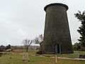
Geldmacher's windmill tower at Nimmitabel
-
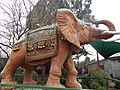
The concrete elephant “George” at the Nimmitabel Bakery
-
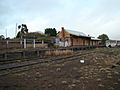
Nimmitabel railway station 21 years after the last train


