Niska Isle facts for kids

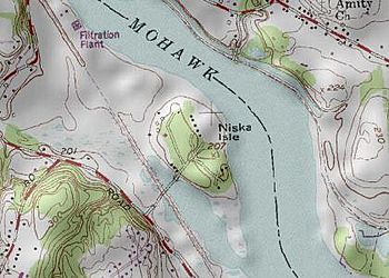
Map of Niska Isle
|
|
| Geography | |
|---|---|
| Location | Mohawk River |
| Coordinates | 42°47′24″N 73°50′02″W / 42.79000°N 73.83389°W |
| Highest elevation | 207 ft (63.1 m) |
| Administration | |
| Town | Niskayuna, New York |
Niska Isle is a special piece of land in Niskayuna, New York. Even though its name sounds like "island," it's actually a peninsula. This means it's land mostly surrounded by water, but it's still connected to the main land on one side. Niska Isle sits along the southern edge of the Mohawk River. A small bay and swamp surround it to the south.
Contents
History of Niska Isle
Before 1915, Niska Isle was a small, raised area of land. It was about half a mile long and a quarter of a mile wide. This spot was easy to defend because it was at the meeting point of the Lisha Kill (a small creek) and the Mohawk River.
Long ago, a Native American village was located here. A path from the village led to other important places like the Normans Kill and the Helderberg Escarpment.
In 1790, a man named Eldert Vischer started a rope ferry. This ferry helped people cross the river, connecting Ferry Road on the Niskayuna side to the other bank. A bridge was built in 1900 to replace the ferry, but it only lasted for two years.
In 1915, the Mohawk River was dammed to create the New York State Barge Canal. This big project caused the mouth of the Lisha Kill to become a back bay. Because of this, a new bridge had to be built to connect Ferry Road to the "mainland."
By 2008, this bridge was getting old, even after being repaired in the 1980s. Some people thought about getting rid of Niska Isle, but it would have cost too much money to buy out the landowners. So, a new bridge was built in 2010, costing almost as much as the buy-out.
Who Lives on Niska Isle?
Niska Isle is home to about nine families. Most of the land belongs to two main families: the Schoolcrafts and the Burgers.
The Schoolcraft family owns most of the land south and east of Ferry Road. They have lived there since 1937, though they owned land on the isle even earlier. The Burger family has lived on the land north of the road to Lock 7 since 1947. They had worked and rented land there since the late 1800s. A few other families live in houses that look over the Ferry Road bridge.
Geography of Niska Isle
To the north and east of Niska Isle is the Mohawk River. This river separates Niska Isle from the small community of Vischer Ferry, New York in Saratoga County, New York.
To the south of Niska Isle is a back bay. The Lisha Kill creek flows into this bay. This bay often gets filled with water chestnuts, which are plants that are not native to the area and can cause problems.
In winter, the Mohawk River can get blocked by ice jams. This means that ice builds up and can cause flooding on Niska Isle. A very big flood happened in the 1980s.
Getting Around Niska Isle
The only way to get to Niska Isle by land is over a bridge. This bridge carries Ferry Road over an old railroad path, which is now the Mohawk Hudson Hike/Bike Trail. It also crosses the back bay.
The first bridge was a single-lane bridge built around 1915. It was needed because the Barge Canal project flooded the area and cut off Niska Isle from the rest of the land. Since the Mohawk River is part of the Barge Canal, the bridge was owned by different state groups over the years. The bridge deck was replaced in the 1980s. In 2010, a brand new bridge, about 588 feet long, was built.
Fun Things to Do on Niska Isle
At the end of Ferry Road, near the river, there's a small parking area. This spot is great for people who want to go fishing or launch a boat.
You can catch many types of fish near Niska Isle. These include bass, pike, muskie, panfish, and large carp that can weigh 20 to 30 pounds!
 | George Robert Carruthers |
 | Patricia Bath |
 | Jan Ernst Matzeliger |
 | Alexander Miles |

