
Niterói facts for kids
Quick facts for kids
Niterói
|
|||
|---|---|---|---|
|
Municipality
|
|||
| Municipality of Niterói | |||
|
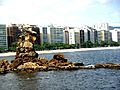
Icaraí Beach
Contemporary Art Museum
Caminho Niemeyer
Mocanguê Island and Rio–Niterói Bridge
Santa Cruz da Barra Fortress
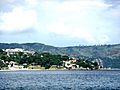
Guanabara Bay as seen from Niterói
|
|||
|
|||
| Nickname(s):
Cidade Sorriso (Smile City)
|
|||

Location in Rio de Janeiro
|
|||
| Country | |||
| Region | Southeast | ||
| State | |||
| Founded | 22 November 1573 | ||
| Area | |||
| • Total | 129.38 km2 (49.95 sq mi) | ||
| Elevation | 0 m (0 ft) | ||
| Population
(2020)
|
|||
| • Total | 515,317 | ||
| • Density | 3,982.97/km2 (10,315.9/sq mi) | ||
| Time zone | UTC−3 (BRT) | ||
| Postal Code |
24000-000
|
||
| Area code(s) | 21 | ||
| HDI (2010) | 0.837 – very high | ||


Niterói is a city in the state of Rio de Janeiro, in the southeast part of Brazil. It sits across Guanabara Bay, right next to the big city of Rio de Janeiro. It's part of the larger Rio de Janeiro area.
Niterói used to be the capital of Rio de Janeiro state for many years, from 1834 to 1894 and again from 1903 to 1975. Today, about 515,317 people live there (as of 2020). The city is known for having a very high Human Development Index, which means it's a great place to live with good education and services. It's even called Cidade Sorriso, which means "Smile City"!
Studies have shown that Niterói is one of Brazil's wealthiest cities. Many people there belong to higher income groups. It's also an important place for business, trade, and industry in the state of Rio de Janeiro.
Niterói was founded on November 22, 1573, by a Tupi chief named Arariboia. This makes it special because it's the only Brazilian city started by an indigenous person who wasn't Christian at the time. The city is also home to part of the Serra da Tiririca State Park, a large natural area.
Contents
What Does the Name Niterói Mean?
The name "Niterói" comes from the Tupi language. It means "the (bay) all sinuous" or "hidden waters." This name describes the curvy shape of the bay where the city is located.
A Look at Niterói's History
Early Days: French and Portuguese
In 1555, a French explorer named Nicolas Durand de Villegaignon teamed up with the Tupinambas Indians. They started a French colony called France Antarctique in the Guanabara Bay area. The Portuguese avoided this region because the Tupinambas were not friendly.
Villegaignon wanted to build a city there. But some French settlers went back to France and complained about him. So, he had to return to France to explain himself.
While the French leader was away, the Portuguese realized how important the Guanabara Bay was. It was a perfect stop for ships traveling from Portugal to Africa and Asia. It was also a good place to defend southern Brazil.
In 1560, the Portuguese leader Mem de Sá attacked the French fort in the bay. He destroyed it, but the French were not completely gone yet. His nephew, Estácio de Sá, continued the fight. He asked for help from Arariboia, the chief of the Temiminos Indians. Arariboia agreed to help the Portuguese get rid of the French. He hoped to get his homeland back.
After the war ended in 1567, Estácio de Sá asked Arariboia and his Temininós people to settle on the eastern side of the Guanabara Bay. This area was known as "Banda D'Além" (the land beyond). It was across from the city of São Sebastião do Rio de Janeiro, which Estácio had founded in 1565. This way, the entrance to the bay would be safe from other invaders.
In this "Land Beyond," Arariboia founded the Town of Saint Lawrence of the Indians. This was the beginning of what would become Niterói.
Imperial Times: A Capital City
- A New Name and Importance: In 1816, the King of Brazil, John VI of Portugal, visited the village. In 1819, he made it a separate municipality and named it Vila Real da Praia Grande (Royal Town of Great Beach).
- Becoming a Capital: In 1834, Rio de Janeiro city became a special "neutral municipality." So, Vila Real da Praia Grande was chosen as the new capital of the Rio de Janeiro province. Niterói remained the capital until 1975, except for a short time between 1894 and 1903 when the capital moved to Petrópolis.
- "Imperial City": On March 6, 1835, the city was officially renamed Nictheroy. Later, the spelling changed to the current "Niterói." Being the capital brought many improvements, like steam boats, public lighting, and water supply. Nine years later, Emperor D. Pedro II gave Niterói the special title of "Imperial City." This title was given to important cities and gave them more power.
- City Growth: By the late 1800s, tram systems were built. This helped the city grow to areas like Icaraí and Itaipu.
Republican Era: Changes and Challenges
- State Capital Again: In 1890, Brazilian provinces became states. After a navy revolt in 1893, the capital moved to Petrópolis for a while. But in 1903, Niterói became the capital of Rio de Janeiro state again. This led to more modern changes, like new squares, parks, and wider streets.
- Tragic Fire: On December 17, 1961, a terrible circus fire happened in the city. It killed 323 people and was one of Brazil's worst tragedies.
- Losing Capital Status: In 1960, Brazil's capital moved to Brasília. In 1975, the state of Guanabara (which was Rio de Janeiro city) merged with Rio de Janeiro State. Niterói then lost its role as the state capital, and Rio de Janeiro city became the capital.
- Recent Events: In April 2010, heavy rain caused a mudslide. This event caused many people to leave their homes.
Geography of Niterói
Niterói covers an area of 129.375 square kilometers. It's located between the Guanabara Bay to the west and the Atlantic Ocean to the south. To its east is Maricá, and to its north is São Gonçalo.
Beautiful Beaches and Lagoons
Niterói has many beautiful beaches:
- Praia de Fora and Praia do Imbuí are important for their history.
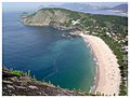
- Piratininga Beach, Camboinhas Beach, Itaipu Beach, and Itacoatiara Beach are very popular.
- Praia do Sossego, Praia Adam and Eve, and Prainha are also lovely.
The city also has two saltwater lagoons: Piratininga and Itaipu. They are connected by a canal. The Itaipu Lagoon also connects to the sea through another canal.
Mountains and Plains
The land in Niterói has mountains and coastal hills. The highest point is the Stone of the Elephant, which is 412 meters high. There are also flat coastal areas near the sea, especially around the Piratininga and Itaipu lagoons.
Climate
Niterói has a tropical climate. This means it has warm to hot temperatures all year round and gets a good amount of rain.
| Climate data for Niterói (1931–1960) | |||||||||||||
|---|---|---|---|---|---|---|---|---|---|---|---|---|---|
| Month | Jan | Feb | Mar | Apr | May | Jun | Jul | Aug | Sep | Oct | Nov | Dec | Year |
| Mean daily maximum °C (°F) | 32.2 (90.0) |
32.4 (90.3) |
31.5 (88.7) |
29.1 (84.4) |
27.4 (81.3) |
26.6 (79.9) |
26.1 (79.0) |
26.9 (80.4) |
27.0 (80.6) |
27.9 (82.2) |
28.7 (83.7) |
30.1 (86.2) |
28.8 (83.8) |
| Daily mean °C (°F) | 26.4 (79.5) |
26.5 (79.7) |
25.7 (78.3) |
23.6 (74.5) |
21.5 (70.7) |
20.2 (68.4) |
19.6 (67.3) |
20.5 (68.9) |
21.4 (70.5) |
22.6 (72.7) |
23.6 (74.5) |
25.0 (77.0) |
23.0 (73.4) |
| Mean daily minimum °C (°F) | 22.1 (71.8) |
22.2 (72.0) |
21.6 (70.9) |
19.6 (67.3) |
17.3 (63.1) |
15.6 (60.1) |
14.8 (58.6) |
15.6 (60.1) |
17.1 (62.8) |
18.6 (65.5) |
19.6 (67.3) |
20.8 (69.4) |
18.7 (65.7) |
| Average precipitation mm (inches) | 147.1 (5.79) |
136.7 (5.38) |
149.4 (5.88) |
124.0 (4.88) |
89.9 (3.54) |
55.9 (2.20) |
52.3 (2.06) |
50.1 (1.97) |
59.3 (2.33) |
87.9 (3.46) |
115.8 (4.56) |
139.3 (5.48) |
1,207.7 (47.55) |
| Average relative humidity (%) | 74.8 | 76.0 | 77.5 | 79.5 | 80.8 | 81.2 | 79.4 | 75.9 | 76.3 | 76.8 | 76.7 | 76.9 | 77.6 |
| Mean monthly sunshine hours | 196.7 | 179.8 | 189.3 | 159.9 | 144.2 | 134.7 | 156.6 | 182.5 | 139.8 | 146.0 | 157.3 | 161.5 | 1,948.3 |
| Source: Instituto Nacional de Meteorologia | |||||||||||||
Economy and Growth
Niterói is a very important center for money and business in Rio de Janeiro State. It's a modern city with many new buildings and shopping malls. Its economy mainly focuses on services like real estate, graphic design, and advertising.
The city also has industries that make food (especially seafood), clothes, and candles. Niterói is only about 25 minutes away from Rio de Janeiro's downtown. It's the fourth wealthiest city in Rio de Janeiro State.
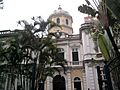
The Niterói Contemporary Art Museum is a famous landmark. It was designed by the well-known Brazilian architect Oscar Niemeyer. The Niterói Tower, a tall office building, also stands out in the city center.
How Niterói Grew
- Early Expansion: When Niterói first became a city, it was mostly just its central area. The southern part of the city started to grow in 1841. Areas like Jurujuba grew from old fishing villages.
- Connecting the City: The eastern part of Niterói, called Itaipu, used to be mostly farms and forests. It became part of the city in 1943. After the Rio–Niterói Bridge was built, Itaipu grew quickly. Roads and city services improved, connecting the different parts of Niterói better.
- Industry: In the early 1900s, Niterói also started to develop its industries.
People of Niterói
Niterói is about 14 kilometers (9 miles) from Rio de Janeiro City. You can get there by crossing the Rio–Niterói Bridge or by ferryboat. In 2010, the city had 487,320 people. It's the fifth most populated city in Rio de Janeiro state.
Niterói is known for its high quality of life. Many people in Niterói have a good standard of living.
| Year | Population |
|---|---|
| 1950 | 698,582 |
| 1970 | 513,771 |
| 1990 | 431,070 |
| 2000 | 459,451 |
| 2010 | 487,327 |
Religions in Niterói

Many different religions are practiced in Niterói. According to the 2010 census:
- About 53% of the people were Roman Catholic.
- About 35% were evangelicals (Protestants).
- About 11% were Spiritists.
The city is also home to a Jewish community and followers of Buddhism, messianism, and Afro-Brazilian religions.
Education in Niterói
Niterói is a center for learning. It's home to the Fluminense Federal University, which is a very important research center in Brazil. Other colleges like ISE La Salle and Cândido Mendes University are also there.
Many traditional elementary and high schools are in Niterói, including Catholic schools like La Salle Institute and São Vicente de Paulo. Other important schools are PH, Marília Matoso, Pedro II, Gay Lussac, Instituto Abel, and the Salesian High School.
Niterói has the highest Human Development Index (HDI) and the best level of literacy in Rio de Janeiro State. This means people in Niterói are well-educated.
Getting Around Niterói
Buses
Buses are the only public transportation system within Niterói. There are almost 50 bus lines, all run by private companies. Most buses either start or pass through the city center.
Ferries

You can travel by sea between Niterói and Rio de Janeiro city. There are two ferry routes, both going to Praça XV Station in Rio. In Niterói, the ferry stations are at Arariboia Square and in the Charitas neighborhood.
- Arariboia to Praça 15 de Novembro: Large boats carry up to 2,000 passengers. The trip takes about 20 minutes. Since 2006, newer, faster catamarans (holding up to 1,200 passengers) have been used, cutting the travel time to 12-15 minutes.
- Charitas to Praça 15 de Novembro: Smaller catamarans are used for this route, offering a more selective service.
Trains (Past)
Niterói used to have a train line for passengers that was 33 km long. It connected Niterói to Itaboraí, passing through São Gonçalo. This train line stopped running in 2007. Now, the tracks have been removed in many places. There are plans to use this path for a new subway line (Line 3) of the Rio Metro in the future.
Culture in Niterói
Niterói is a major historical and cultural center in Brazil. Its culture is a mix of old and new. You can find fishing villages like Jurujuba, old forts, and modern buildings.
The Niterói Contemporary Art Museum is a symbol of the city. It was designed by the famous architect Oscar Niemeyer. The Popular Theater of Niterói is another futuristic building. The people of Niterói are known for being very welcoming, which is why it's called "Smile City."
The city's architecture shows a blend of history and the future. Old buildings like the Niterói State Library and the Municipal Theater stand next to modern works like the Museum of Contemporary Art.
Catholic churches also play a big part in Niterói's culture. Churches like São Lourenço dos Índios Church (which marks the city's founding) and the Cathedral of Saint John the Baptist show off beautiful old architectural styles.
Sports in Niterói

Niterói is the hometown of famous football (soccer) stars like Leonardo, Edmundo, and Gérson.
The city is also home to the Canto do Rio Foot-Ball Club, founded in 1913. This club was special because it was the only one from outside Rio de Janeiro city to play in the Rio de Janeiro Championship in the 1940s. The club even had its anthem written by a famous composer, Lamartine Babo!
Other football clubs in Niterói include the Fonseca Athletic Club and the Rio Cricket and Athletic Association. Rio Cricket was part of the first championship in Rio and even hosted games in its stadium.
Niterói also has the Caio Martins Stadium. This stadium has been home to Canto do Rio and, more recently, Botafogo. In 2007, the stadium's gym hosted the final of the Brazilian Volleyball Super League for women. Today, it's used for training and for games in lower football divisions.
City Areas
From 1943 to the late 1970s, Niterói had only two main areas: the original Niterói district and the Itaipu district. These areas were not well connected. But after the Rio-Niterói Bridge was built, Itaipu grew a lot. Roads and city services improved, bringing the areas closer.
Now, Niterói is divided into five main "Planning Regions," which are then split into 52 neighborhoods:
| Praias da Baía (Bay Beaches) |
|---|
| Bairro de Fátima |
| Boa Viagem |
| Cachoeiras |
| Centro (Downtown) |
| Charitas |
| Gragoatá |
| Icaraí |
| Ingá |
| Jurujuba |
| Morro do Estado |
| Pé Pequeno |
| Ponta d'Areia |
| Santa Rosa |
| São Domingos |
| São Francisco |
| Viradouro |
| Vital Brazil |
| Norte (North) |
|---|
| Baldeador |
| Barreto |
| Caramujo |
| Cubango |
| Engenhoca |
| Fonseca |
| Ilha da Conceição |
| Santa Bárbara |
| Santana |
| São Lourenço |
| Tenente Jardim |
| Viçoso Jardim |
| Oceânica (Oceanic) |
|---|
| Cafubá |
| Camboinhas |
| Engenho do Mato |
| Itacoatiara |
| Itaipu |
| Jacaré |
| Jardim Imbuí |
| Maravista |
| Piratininga |
| Santo Antônio |
| Serra Grande |
| Pendotiba |
|---|
| Badu |
| Cantagalo |
| Ititioca |
| Largo da Batalha |
| Maceió |
| Maria Paula |
| Matapaca |
| Sapê |
| Vila Progresso |
| Leste (East) |
|---|
| Muriqui |
| Rio do Ouro |
| Várzea das Moças |
Famous People from Niterói
|
|
Images for kids
-
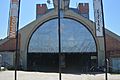
João Goulart Bus Terminal in downtown Niterói
-
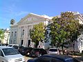
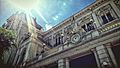
Niterói State Library
-
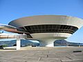
Niterói Contemporary Art Museum
-
The Gragoatá campus of the Fluminense Federal University
-
Correios Palace
-
Arariboia Palace
-
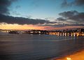
Night view of Icaraí Beach
-
Old and new architecture mingle together in Niterói
-
The neighborhood of Icaraí
-
Itacoatiara beach
-
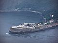
Santa Cruz Fortress
-
Fróes cove
-
Icaraí beach in 1895
-
View of Rio de Janeiro from Icaraí beach


See also
 In Spanish: Niterói para niños
