North Moat Mountain facts for kids
Quick facts for kids North Moat Mountain |
|
|---|---|

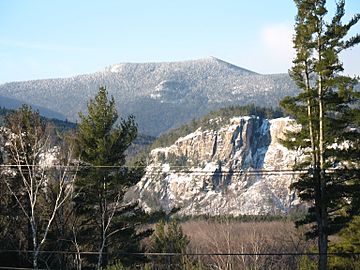
North Moat Mountain, looking southwest from Intervale. Cathedral Ledge cliff is in right middleground.
|
|
| Highest point | |
| Elevation | 974 m (3,196 ft) |
| Prominence | 320 m (1,050 ft) |
| Geography | |
| Location | Carroll County, New Hampshire, U.S. |
| Topo map | USGS North Conway West |
North Moat Mountain is a cool mountain located in Carroll County, New Hampshire. It's part of a group of mountains called the Moat Mountains. To its south, you'll find Middle Moat Mountain, and to its west is Big Attitash Mountain.
About North Moat Mountain
North Moat Mountain stands tall in the beautiful state of New Hampshire. It's a popular spot for hikers and nature lovers. The mountain is known for its scenic views and the forests that cover its slopes.
Where the Water Goes
Imagine a giant funnel that collects all the rain and snow that falls on a mountain. That's kind of like a watershed! North Moat Mountain is part of the watershed for the upper Saco River. This means all the water that flows off the mountain eventually makes its way into the Saco River.
The Saco River is a big river that travels all the way to the Gulf of Maine. This gulf is part of the Atlantic Ocean. So, a raindrop that falls on North Moat Mountain could end up in the ocean!
Water Flow Details
Different sides of North Moat Mountain send their water in different directions:
- Water from the northwest side flows into a stream called Lucy Brook. This brook then joins the Saco River.
- On the east side, water drains into Moat Brook, which also flows into the Saco River.
- The southwest side sends its water into Deer Brook. Deer Brook then flows into the Swift River. The Swift River is a smaller river that also joins the Saco River.
It's pretty neat how all these streams and rivers connect, carrying water from the mountain down to the sea!
 | Jessica Watkins |
 | Robert Henry Lawrence Jr. |
 | Mae Jemison |
 | Sian Proctor |
 | Guion Bluford |

