Norwich (CDP), Vermont facts for kids
Quick facts for kids
Norwich, Vermont
|
|
|---|---|

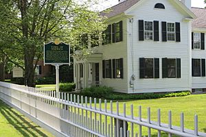
Norwich Historical Society building on South Main Street
|
|

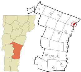
Location in Windsor County and the state of Vermont
|
|
| Country | United States |
| State | Vermont |
| County | Windsor |
| Area | |
| • Total | 1.5 sq mi (3.8 km2) |
| • Land | 1.5 sq mi (3.8 km2) |
| • Water | 0 sq mi (0.0 km2) |
| Elevation | 537 ft (164 m) |
| Population
(2010)
|
|
| • Total | 878 |
| • Density | 598/sq mi (231/km2) |
| Time zone | UTC-5 (Eastern (EST)) |
| • Summer (DST) | UTC-4 (EDT) |
| ZIP code |
05055
|
| Area code(s) | 802 |
| FIPS code | 50-52825 |
| GNIS feature ID | 1458786 |
Norwich is a small community in Windsor County, Vermont, in the United States. It's known as a "census-designated place" (CDP), which means it's a specific area defined for counting people. In 2010, about 878 people lived in this central village area. The larger town of Norwich, which includes this village, had a population of 3,414 people.
Contents
Exploring Norwich's Location
Norwich is found in the northeastern part of Windsor County. It's easy to get to, with major roads running through or near it.
Main Roads and Connections
U.S. Route 5 goes right through the village. This road connects Norwich to Thetford to the north and White River Junction to the south.
Interstate 91 runs along the eastern edge of the village. You can get into Norwich from this highway at Exit 13.
Crossing the Connecticut River
From Exit 13, Vermont Route 10A heads east. This route takes you across the Connecticut River into Hanover, New Hampshire.
See also
 In Spanish: Norwich (condado de Windsor) para niños
 | Dorothy Vaughan |
 | Charles Henry Turner |
 | Hildrus Poindexter |
 | Henry Cecil McBay |

