Oakland, Tennessee facts for kids
Quick facts for kids
Oakland, Tennessee
|
|||
|---|---|---|---|

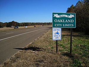
Oakland welcome sign
|
|||
|
|||
| Nickname(s):
"The Crossroads of North America"
|
|||

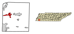
Location of Oakland in Fayette County, Tennessee.
|
|||
| Country | United States | ||
| State | Tennessee | ||
| County | Fayette | ||
| Area | |||
| • Total | 10.45 sq mi (27.08 km2) | ||
| • Land | 10.42 sq mi (26.99 km2) | ||
| • Water | 0.03 sq mi (0.09 km2) | ||
| Elevation | 381 ft (116 m) | ||
| Population
(2020)
|
|||
| • Total | 8,936 | ||
| • Density | 857.50/sq mi (331.08/km2) | ||
| Time zone | UTC-6 (Central (CST)) | ||
| • Summer (DST) | UTC-5 (CDT) | ||
| ZIP code |
38060
|
||
| Area code(s) | 901 | ||
| FIPS code | 47-54920 | ||
| GNIS feature ID | 1296176 | ||
Oakland is a growing town in Fayette County, Tennessee, United States. It's known for being a safe place to live. In 2020, about 8,936 people lived there. The town has grown a lot since 2000. This growth is partly because of lower taxes and a low crime rate. Also, a major road, U.S. Highway 64, was made bigger in the 1990s, which helped the town grow. In 2023, Oakland was ranked as the second safest town in all of Tennessee.
Contents
Geography and Climate in Oakland
Oakland is located in the western-central part of Fayette County. The main road through town is US 64. This highway goes east about 9 miles (14 km) to Somerville, which is the county seat. If you go west on US 64, it's about 32 miles (51 km) to downtown Memphis. The border between Tennessee and Mississippi is about 18 miles (29 km) to the south. Other important roads in Oakland are Tennessee Routes 194 and 196, which run north and south.
The town has grown quite a bit over the years. In 2010, Oakland covered about 26.6 square kilometers (10.3 sq mi). This is much larger than its size in 2000, which was 3.6 square miles (9.3 km²). The town's borders have expanded, especially to the west along US 64. It now stretches almost 6.5 miles (10.5 km) close to the Shelby County line.
Oakland's Weather Patterns
The climate in Oakland is similar to that of Memphis. Here's a look at the typical weather conditions:
| Climate data for Memphis (Memphis Int'l), 1981−2010 normals, extremes 1872−present | |||||||||||||
|---|---|---|---|---|---|---|---|---|---|---|---|---|---|
| Month | Jan | Feb | Mar | Apr | May | Jun | Jul | Aug | Sep | Oct | Nov | Dec | Year |
| Record high °F (°C) | 79
(26) |
81
(27) |
87
(31) |
94
(34) |
99
(37) |
104
(40) |
108
(42) |
107
(42) |
103
(39) |
98
(37) |
86
(30) |
81
(27) |
108
(42) |
| Mean maximum °F (°C) | 70.0
(21.1) |
74.0
(23.3) |
80.6
(27.0) |
85.9
(29.9) |
90.5
(32.5) |
95.8
(35.4) |
98.0
(36.7) |
98.4
(36.9) |
94.6
(34.8) |
87.7
(30.9) |
79.4
(26.3) |
70.7
(21.5) |
99.7
(37.6) |
| Average high °F (°C) | 49.8
(9.9) |
54.7
(12.6) |
63.9
(17.7) |
73.0
(22.8) |
81.2
(27.3) |
88.9
(31.6) |
91.6
(33.1) |
91.3
(32.9) |
85.1
(29.5) |
74.4
(23.6) |
62.6
(17.0) |
52.1
(11.2) |
72.4
(22.4) |
| Daily mean °F (°C) | 41.2
(5.1) |
45.5
(7.5) |
54.0
(12.2) |
62.9
(17.2) |
71.7
(22.1) |
79.6
(26.4) |
82.7
(28.2) |
82.0
(27.8) |
75.1
(23.9) |
64.1
(17.8) |
53.1
(11.7) |
43.6
(6.4) |
63.0
(17.2) |
| Average low °F (°C) | 32.6
(0.3) |
36.3
(2.4) |
44.1
(6.7) |
52.9
(11.6) |
62.2
(16.8) |
70.3
(21.3) |
73.8
(23.2) |
72.7
(22.6) |
65.2
(18.4) |
53.8
(12.1) |
43.7
(6.5) |
35.1
(1.7) |
53.6
(12.0) |
| Mean minimum °F (°C) | 15.0
(−9.4) |
19.5
(−6.9) |
27.0
(−2.8) |
36.1
(2.3) |
49.0
(9.4) |
59.6
(15.3) |
66.2
(19.0) |
64.1
(17.8) |
50.0
(10.0) |
37.9
(3.3) |
28.0
(−2.2) |
18.3
(−7.6) |
10.8
(−11.8) |
| Record low °F (°C) | −8
(−22) |
−11
(−24) |
12
(−11) |
27
(−3) |
36
(2) |
48
(9) |
52
(11) |
48
(9) |
36
(2) |
25
(−4) |
9
(−13) |
−13
(−25) |
−13
(−25) |
| Average precipitation inches (mm) | 3.98
(101) |
4.39
(112) |
5.16
(131) |
5.50
(140) |
5.25
(133) |
3.63
(92) |
4.59
(117) |
2.88
(73) |
3.09
(78) |
3.98
(101) |
5.49
(139) |
5.74
(146) |
53.68
(1,363) |
| Average snowfall inches (cm) | 1.9
(4.8) |
1.3
(3.3) |
0.4
(1.0) |
0
(0) |
0
(0) |
0
(0) |
0
(0) |
0
(0) |
0
(0) |
0
(0) |
trace | 0.2
(0.51) |
3.8
(9.7) |
| Average precipitation days (≥ 0.01 in) | 9.5 | 9.2 | 10.5 | 9.6 | 10.3 | 9.0 | 8.8 | 6.8 | 7.3 | 7.5 | 9.5 | 9.7 | 107.7 |
| Average snowy days (≥ 0.1 in) | 1.2 | 0.8 | 0.4 | 0 | 0 | 0 | 0 | 0 | 0 | 0 | 0 | 0.4 | 2.8 |
| Average relative humidity (%) | 68.2 | 66.4 | 63.2 | 62.5 | 66.4 | 66.8 | 69.1 | 69.6 | 71.3 | 66.2 | 67.7 | 68.8 | 67.2 |
| Mean monthly sunshine hours | 166.6 | 173.8 | 215.3 | 254.6 | 301.5 | 320.6 | 326.9 | 307.0 | 251.2 | 245.9 | 173.0 | 151.9 | 2,888.3 |
| Percent possible sunshine | 53 | 57 | 58 | 65 | 69 | 74 | 74 | 74 | 68 | 70 | 56 | 50 | 65 |
| Source: NOAA (relative humidity 1961−1990, sun 1961−1987) | |||||||||||||
Oakland's Population History
Oakland has seen its population change a lot over the years. Here's how many people have lived in the town during different census years:
| Historical population | |||
|---|---|---|---|
| Census | Pop. | %± | |
| 1880 | 66 | — | |
| 1930 | 237 | — | |
| 1940 | 251 | 5.9% | |
| 1950 | 236 | −6.0% | |
| 1960 | 306 | 29.7% | |
| 1970 | 353 | 15.4% | |
| 1980 | 472 | 33.7% | |
| 1990 | 392 | −16.9% | |
| 2000 | 1,279 | 226.3% | |
| 2010 | 6,623 | 417.8% | |
| 2020 | 8,936 | 34.9% | |
| Sources: | |||
Population Makeup in 2020
The 2020 United States Census showed the different groups of people living in Oakland. This table breaks down the racial makeup of the town:
| Race | Num. | Perc. |
|---|---|---|
| White | 6,109 | 68.36% |
| Black or African American | 2,046 | 22.90% |
| Native American | 6 | 0.07% |
| Asian | 79 | 0.88% |
| Other/Mixed | 395 | 4.42% |
| Hispanic or Latino | 301 | 3.37% |
In 2020, there were 8,936 people living in Oakland. These people made up 3,100 households. Out of these, 2,490 were families.
Oakland's Economy and Businesses
Even though Oakland is smaller than some other towns, it has a busy economy. In 2007, Oakland issued more building permits than many larger suburbs in the Memphis area. This shows that a lot of new homes and buildings were being constructed.
Most of the businesses in Oakland are retail stores. These are places where you can buy things, like clothes or groceries. A company called RING Container Technologies has its main office in Oakland. They make plastic products. Long ago, in the early 1900s, Oakland was famous for having Tennessee's biggest egg factory. It also had a large Christmas tree farm. Today, Oakland has a golf course called "The Fair Oaks Golf Course," which opened in the year 2000.
See also
 In Spanish: Oakland (Tennessee) para niños
 | DeHart Hubbard |
 | Wilma Rudolph |
 | Jesse Owens |
 | Jackie Joyner-Kersee |
 | Major Taylor |


