Oakvale, West Virginia facts for kids
Quick facts for kids
Oakvale, West Virginia
|
|
|---|---|

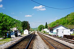
View along the railroad tracks in Oakvale
|
|

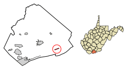
Location of Oakvale in Mercer County, West Virginia.
|
|
| Country | United States |
| State | West Virginia |
| County | Mercer |
| Area | |
| • Total | 0.42 sq mi (1.09 km2) |
| • Land | 0.42 sq mi (1.08 km2) |
| • Water | 0.00 sq mi (0.01 km2) |
| Elevation | 1,732 ft (528 m) |
| Population
(2020)
|
|
| • Total | 137 |
| • Estimate
(2021)
|
136 |
| • Density | 267.94/sq mi (103.50/km2) |
| Time zone | UTC-5 (Eastern (EST)) |
| • Summer (DST) | UTC-4 (EDT) |
| ZIP code |
24739
|
| Area code(s) | 304 |
| FIPS code | 54-60196 |
| GNIS feature ID | 2391339 |
Oakvale is a small town in Mercer County, West Virginia, in the United States. It sits right by the East River. In 2020, about 137 people lived there. Oakvale is part of a larger area called the Bluefield micropolitan area. This area includes parts of West Virginia and Virginia, and it has over 100,000 people.
Contents
History of Oakvale
Oakvale was not always called Oakvale. Its first name was "Frenchville." This name came from an early settler, Captain Napoleon French.
Later, the town was renamed Oakvale. This new name was chosen because of the many oak trees that grew in the valley. The town officially became a town in 1907. This means it got its own local government.
Geography of Oakvale
Oakvale is located in a narrow valley. The East River flows through this valley. The town is only a few miles from the border between Virginia and West Virginia.
You can reach Oakvale using West Virginia Route 112. This road is also known as Ingleside Road. It connects Oakvale to Bluefield, which is to the southwest. Another important road, U.S. Route 460, passes just north of the town.
The town covers a total area of about 0.42 square miles (1.09 square kilometers). All of this area is land.
Population of Oakvale
| Historical population | |||
|---|---|---|---|
| Census | Pop. | %± | |
| 1910 | 278 | — | |
| 1920 | 281 | 1.1% | |
| 1930 | 261 | −7.1% | |
| 1940 | 273 | 4.6% | |
| 1950 | 239 | −12.5% | |
| 1960 | 267 | 11.7% | |
| 1970 | 292 | 9.4% | |
| 1980 | 208 | −28.8% | |
| 1990 | 165 | −20.7% | |
| 2000 | 142 | −13.9% | |
| 2010 | 121 | −14.8% | |
| 2020 | 137 | 13.2% | |
| 2021 (est.) | 136 | 12.4% | |
| U.S. Decennial Census | |||
2010 Census Information
In 2010, the town of Oakvale had 121 people living there. These people lived in 49 households. A household is a group of people living in one home. Out of these, 31 were families.
The population density was about 288 people per square mile. This means there were 288 people for every square mile of land. There were 55 housing units in total.
All the people living in Oakvale in 2010 were White.
Households and Families
About 28.6% of the households had children under 18 years old. Almost 43% of households were married couples living together. Some households had a single parent, either a mother or a father. About 36.7% of households were not families.
The average household had 2.47 people. The average family had 2.94 people.
Age and Gender
The average age of people in Oakvale in 2010 was 41.9 years.
- 24% of residents were under 18 years old.
- About 5% were between 18 and 24 years old.
- Around 27% were between 25 and 44 years old.
- Another 27% were between 45 and 64 years old.
- About 16.5% were 65 years or older.
When it came to gender, 52.1% of the people were male. The other 47.9% were female.
See also
 In Spanish: Oakvale (Virginia Occidental) para niños


