Upper Franconia Government Region facts for kids
Quick facts for kids
Upper Franconia
Oberfranken
|
|
|---|---|

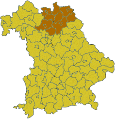
Map of Bavaria highlighting the Regierungsbezirk of Upper Franconia
|
|
| Country | Germany |
| State | Bavaria |
| Region seat | Bayreuth |
| Area | |
| • Total | 7,230.19 km2 (2,791.59 sq mi) |
| Population
(31 Dec. 2006)
|
|
| • Total | 1,094,525 |
| • Density | 151.38261/km2 (392.0791/sq mi) |
| Website | regierung.oberfranken.bayern.de |
Upper Franconia (which is Oberfranken in German) is a special administrative region in the German state of Bavaria. Think of it like a big county or district. It covers an area of about 7,230 square kilometers. That's roughly the size of a small country! Around 1.1 million people live here.
Upper Franconia shares its borders with other German states like Saxony and Thuringia. It also borders the Czech Republic. The main city and capital of Upper Franconia is Bayreuth.
Contents
What is Upper Franconia?
Upper Franconia is one of the seven regierungsbezirke (administrative regions) in Bavaria. These regions help manage different parts of the state. Each region has its own government office. This office makes sure that state laws are followed and that public services work well. They handle things like schools, roads, and environmental protection.
Cities and Districts in Upper Franconia
Upper Franconia has many interesting cities and smaller towns. It also has several rural districts. These areas are grouped together for administrative purposes.
Main Cities (Urban Districts)
Some cities in Upper Franconia are called "urban districts." This means they are big enough to manage themselves. They do not belong to a larger rural district. These cities have their own local governments.
Smaller Cities and Towns
There are also many other important cities and towns in Upper Franconia. These places are usually part of a larger rural district. They still have their own local councils and mayors.
- Forchheim
- Kulmbach
- Lichtenfels
- Marktredwitz
- Neustadt bei Coburg
- Kronach
- Rödental
- Wunsiedel
- Selb
- Münchberg
- Helmbrechts
- Rehau
- Stadtsteinach
- Bad Staffelstein
- Ebermannstadt
- Burgkunstadt
Rural Districts
A "rural district" is an area made up of many smaller towns and villages. These districts work together on things like public transport and waste management. Each rural district has its own administration.


