Oderen facts for kids
Quick facts for kids
Oderen
|
||
|---|---|---|
 |
||
|
||
| Country | France | |
| Region | Grand Est | |
| Department | Haut-Rhin | |
| Arrondissement | Thann-Guebwiller | |
| Canton | Cernay | |
| Intercommunality | Vallée de Saint-Amarin | |
| Area
1
|
19.12 km2 (7.38 sq mi) | |
| Population
(2006)
|
1,337 | |
| • Density | 69.93/km2 (181.11/sq mi) | |
| Time zone | UTC+01:00 (CET) | |
| • Summer (DST) | UTC+02:00 (CEST) | |
| INSEE/Postal code |
68247 /68830
|
|
| Elevation | 445–1,264 m (1,460–4,147 ft) (avg. 460 m or 1,510 ft) |
|
| 1 French Land Register data, which excludes lakes, ponds, glaciers > 1 km2 (0.386 sq mi or 247 acres) and river estuaries. | ||
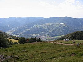
Oderen is a small and charming commune in eastern France. A commune is like a local town or village area. It is located in the Haut-Rhin department. This area is part of the beautiful Alsace region.
Contents
Where is Oderen?
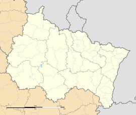
Oderen is found in the Haut-Rhin department. This department is in the Grand Est region of France. It is close to the border with Germany and Switzerland. The commune is nestled in the Vosges Mountains.
Geography and Size
Oderen sits at an elevation of about 460 meters (1,509 feet) above sea level. The lowest point in the commune is 445 meters (1,460 feet). The highest point reaches 1,264 meters (4,147 feet). This shows it has varied landscapes, from valleys to mountain peaks.
The total area of Oderen is 19.12 square kilometers (7.38 square miles). This makes it a medium-sized commune in terms of land area. It includes forests, fields, and the village itself.
How Many People Live There?
In 2006, the population of Oderen was 1,337 people. This means it is a relatively small community. The people who live in Oderen are called Oderenois.
How Oderen is Governed
Like all communes in France, Oderen has its own local government. This government helps manage the daily life of the community. It ensures services like schools and roads are well-maintained.
Local Leaders
The head of the local government is the mayor. The mayor is chosen by the people of the commune. From 2001 to 2008, the mayor of Oderen was Francis Allonas. The mayor works to improve the lives of the residents.
Administrative Divisions
Oderen is part of several larger administrative areas. It belongs to the Thann-Guebwiller arrondissement. An arrondissement is a district within a department. It is also part of the Cernay canton. Cantons are smaller divisions used for elections.
Oderen is also part of an "intercommunality" called Vallée de Saint-Amarin. This means it works together with nearby communes. They share resources and services for the benefit of all their citizens.
History of Oderen
The history of Oderen is tied to the history of the Alsace region. This area has a rich past, often influenced by both French and German cultures. Over centuries, the region has seen many changes.
Life in the Past
Historically, many people in Oderen worked in farming or forestry. The mountains provided timber and other natural resources. Small industries might have also existed, supporting the local economy. Life was often centered around the village and its natural surroundings.
Things to Do in Oderen
Oderen offers a peaceful setting for visitors and residents. Its location in the Vosges Mountains makes it ideal for outdoor activities.
Nature and Outdoors
The surrounding mountains and forests are perfect for hiking and exploring. There are many trails to discover. In winter, the higher elevations might offer opportunities for snow activities. The natural beauty of the area is a big draw.
Local Culture
Like many French communes, Oderen likely has local traditions and events. These might include village festivals or markets. Such events help keep the community spirit strong. They also offer a glimpse into the local culture.
Related pages
See also
 In Spanish: Oderen para niños
 | Valerie Thomas |
 | Frederick McKinley Jones |
 | George Edward Alcorn Jr. |
 | Thomas Mensah |


