Oescus Island facts for kids

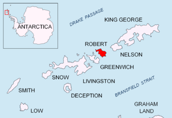
Location of Robert Island in the South Shetland Islands
|
|
|
Location of Oescus Island
|
|
| Geography | |
|---|---|
| Location | Antarctica |
| Coordinates | 62°21′07″S 59°41′15.5″W / 62.35194°S 59.687639°W |
| Archipelago | South Shetland Islands |
| Administration | |
| Administered under the Antarctic Treaty System | |
| Demographics | |
| Population | Uninhabited |
Oescus Island (also known as ostrov Eskus in Bulgarian) is a small, flat island in Antarctica. It's a special place because it's mostly free of ice, even though it's in a very cold region. This island is part of a group called the Onogur Islands. You can find it off the northwest coast of Robert Island, which is part of the South Shetland Islands.
Oescus Island is about 380 meters (about 1,247 feet) long from one end to the other. It's also quite narrow, only about 40 meters (about 131 feet) wide. The island is made of two parts that are connected by a narrow strip of land called a spit. It's close to other islands like Redina Island, Kovach Island, and Leeve Island, with small water passages separating them.
The island got its name from an ancient Roman town called Oescus. This town was located in what is now Northern Bulgaria.
Where is Oescus Island?
Oescus Island is located at coordinates 62°21′07″S 59°41′15.5″W / 62.35194°S 59.687639°W. To help you imagine where it is, it's about 1.42 kilometers (less than a mile) north of a place called Misnomer Point. It's also about 890 meters (about half a mile) west of Shipot Point.
Scientists and mapmakers have been studying this area for a while. British maps of the island were made in 1968. Later, Bulgarian mapmakers created their own maps in 2009, helping us learn even more about Oescus Island.
Maps of the Island
Maps are very important for understanding places like Oescus Island. They show us where everything is located and how big it is.
- A detailed map of the area is available, created by L.L. Ivanov. It's called "Antarctica: Livingston Island and Greenwich, Robert, Snow and Smith Islands." This map is a topographic map, which means it shows the shape and features of the land. It was first published in 2009 and then a second edition came out in 2010.
 | Sharif Bey |
 | Hale Woodruff |
 | Richmond Barthé |
 | Purvis Young |


