
Ogilvie Island facts for kids

USGS aerial imagery of Ogilvie Island
|
|

Ogilvie Island
Location in San Francisco Bay Area

Ogilvie Island
Location in California

Ogilvie Island
Location in the United States
|
|
| Geography | |
|---|---|
| Location | Northern California |
| Coordinates | 37°27′55″N 122°00′37″W / 37.46528°N 122.01028°W |
| Adjacent bodies of water | San Francisco Bay |
| Highest elevation | 0 ft (0 m) |
| Administration | |
|
United States
|
|
| State | |
| County | Santa Clara |
Ogilvie Island is a small piece of land located in the big San Francisco Bay in California. It's part of Santa Clara County. This island is quite low, with an elevation of 0 feet (0 meters) above sea level. This means it can sometimes be covered by water, especially during high tides.
Contents
Where is Ogilvie Island?
Ogilvie Island is found in the southern part of San Francisco Bay. This bay is a large, shallow inlet of the Pacific Ocean. It is surrounded by many cities and towns in Northern California.
Location in Santa Clara County
The island is officially located within Santa Clara County. This county is known for being home to Silicon Valley. The exact spot of Ogilvie Island is at coordinates 37°27′55″N 122°00′37″W / 37.46528°N 122.01028°W.
What Does 0 Feet Elevation Mean?
The United States Geological Survey (USGS) recorded Ogilvie Island's elevation as 0 feet in 2012. This is a very interesting fact about the island.
Understanding Low Elevation
An elevation of 0 feet means the island is at the same level as the surrounding water. Because of this, Ogilvie Island can often be partly or fully underwater. This happens especially during high tides or storms. It shows how the land and water interact in the bay.
Images for kids
-
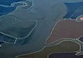
Ogilvie Island (at center) mostly submerged by water, as seen from the northeast in a 2019 aerial photo
.jpg)
