Ohanapecosh Glacier facts for kids
Quick facts for kids Ohanapecosh Glacier |
|
|---|---|

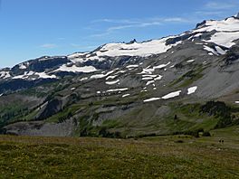
View SSW from Banshee Peak
|
|
| Type | Mountain glacier |
| Location | Mount Rainier, Pierce County, Washington, USA |
| Coordinates | 46°50′09″N 121°40′12″W / 46.8359426°N 121.6700934°W |
| Area | 0.6 square miles (1.6 km2), 1983 |
The Ohanapecosh Glacier is a small glacier found on the southeastern side of Mount Rainier in Washington. It's like a big, slow-moving river of ice.
Contents
What is the Ohanapecosh Glacier?
This glacier is made up of several parts, or "lobes," of ice. These parts are connected by thin areas of snow and ice. Most of the glacier sits high up on the mountain. It is located near two other glaciers, the Whitman and the Fryingpan Glacier.
How Big is the Ohanapecosh Glacier?
The Ohanapecosh Glacier covers about 0.6 square miles (1.6 km2) of land. That's roughly the size of 300 football fields! It holds a huge amount of ice, about 1.3 billion cubic feet (37 million cubic meters).
Where is it Located?
Most of this glacier is found at high elevations. It stretches from about 8,300 feet (2,500 m) down to 7,400 feet (2,300 m). Some parts of the glacier end at cliffs. These cliffs drop ice down to the lower sections of the glacier. The lowest parts of the glacier are in a small valley. They sit at an elevation of about 6,100 ft (1,900 m).
Where Does its Water Go?
When the glacier's ice melts, the water flows into rivers. This meltwater first drains into the Ohanapecosh River. It also flows into the Muddy Fork Cowlitz River. These two rivers meet up about four miles (6 km) outside of Mount Rainier National Park. From there, they join the larger Cowlitz River.
 | Audre Lorde |
 | John Berry Meachum |
 | Ferdinand Lee Barnett |

