
Old Oswestry facts for kids
.jpg)
An easterly view of the western entrance to Old Oswestry hill fort
|
|

Location in Shropshire
|
|
| Location | Oswestry, Shropshire |
|---|---|
| Region | West Midlands |
| Coordinates | 52°52′22″N 3°02′56″W / 52.87273°N 3.04886°W |
| Altitude | 165 m (541 ft) |
| Type | Hillfort |
| Area | 25 ha (62 acres) |
| Diameter | 500 m (550 yd) |
| Circumference | 1,600 yd (1,500 m) |
| Height | 27 m (89 ft) |
| History | |
| Material | earth and wood |
| Founded | 8th century BCE |
| Abandoned | Roman conquest of Britain |
| Periods | Iron Age Roman Britain |
| Cultures | Celtic people of Iron Age Britain |
| Associated with | Cornovii or Ordovices |
| Site notes | |
| Excavation dates | 1939 |
| Archaeologists | William J Varley |
| Management | English Heritage |
| Public access | free |
Old Oswestry is a huge ancient hill fort located near Oswestry in Shropshire, England. It was built during the Iron Age, a very long time ago. This amazing site is one of the best-preserved hill forts in the whole United Kingdom. Some people even call it "The Stonehenge of the Iron Age Period" because it's so important.
After people stopped living there, the hill fort became part of Wat's Dyke. This was a large earth wall built by the Mercian people in the Early Middle Ages. Old Oswestry Hill Fort has been a protected historical site since 1934. Today, English Heritage looks after it. You can visit for free and enjoy amazing views of Wales and parts of England!
Contents
A Look Back in Time
The first people lived at Old Oswestry around 800 BC. They stayed there until the Roman conquest of Britain. These early residents were likely from tribes called the Cornovii or Ordovices.
Building the Fort
The fort's defenses are very complex. This shows that it was built and changed over many years.
- At first, there were just a few round huts on the hill. They had no protection.
- Later, people built two banks and ditches around the huts. This protected an area about the size of seven football fields.
- They made big entrances at the east and west ends. The inner bank was pulled inward to create these gateways.
- Even later, a third bank was added around most of the fort. It wasn't needed on the steep south-east side.
The western entrance was made even stronger. It had unusual rectangular hollows and ridges. The eastern entrance also got two more sets of banks and ditches. Even with all these strong defenses, there's no sign that the Roman army ever attacked Old Oswestry.
Legends and Training
In the Early Medieval period, people believed Old Oswestry was special. They thought it was the birthplace of Queen Ganhumara. She is also known as Guinevere from the famous Arthurian legends.
During the First World War, soldiers used the hill fort for training. The Canadian Expeditionary Force from a nearby camp practiced trench warfare there. Sadly, this caused a lot of damage to the fort's inside. Many large pits and craters were left behind. The famous war poet Wilfred Owen trained here too. He was born in Oswestry.
Protecting Old Oswestry
In 1939, an archaeologist named William J Varley studied the site. His work was very important for understanding the fort. He found that the strong defenses were built in four different stages over time.
Today, English Heritage manages the hill fort. It is free for everyone to visit and explore.
Since 2015, there have been plans to build new homes near the fort. However, many local people and archaeologists are working together to stop these plans. They want to protect this amazing ancient monument for the future.
Images for kids
-
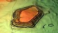
3D view of the digital terrain model

