
Ontario, Ohio facts for kids
Quick facts for kids
Ontario, Ohio
|
|||||
|---|---|---|---|---|---|

Ontario Hellinger Municipal Building
|
|||||
|
|||||
| Motto(s):
"We Serve Community Education Industry"
|
|||||

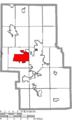
Location of Ontario in Richland County
|
|||||

Ontario, Ohio
Location in Ohio

Ontario, Ohio
Location in the United States
|
|||||
| Country | United States | ||||
| State | Ohio | ||||
| County | Richland | ||||
| Founded | 1834 | ||||
| Incorporated | 1958 (village) | ||||
| - | 2001 (city) | ||||
| Area | |||||
| • Total | 11.09 sq mi (28.72 km2) | ||||
| • Land | 11.07 sq mi (28.66 km2) | ||||
| • Water | 0.02 sq mi (0.06 km2) | ||||
| Elevation | 1,371 ft (418 m) | ||||
| Population
(2020)
|
|||||
| • Total | 6,656 | ||||
| • Density | 601.48/sq mi (232.23/km2) | ||||
| Time zone | UTC-5 (Eastern (EST)) | ||||
| • Summer (DST) | UTC-4 (EDT) | ||||
| ZIP code |
44906
|
||||
| Area code(s) | 419 | ||||
| FIPS code | 39-58520 | ||||
| GNIS feature ID | 2396070 | ||||
| Website | http://www.ontarioohio.org/ | ||||


Ontario is a city located in Richland County, Ohio, in the United States. In 2020, about 6,656 people lived there. It is part of the larger Mansfield metropolitan area.
The city was started in 1834. It is on the western edge of the Allegheny Plateau, close to the city of Mansfield. Ontario became a village in 1958 and then a city in 2001. It grew into a place with many factories because of the Erie Railroad and its closeness to Mansfield.
Later, many factories moved away or changed. Now, Ontario's economy has grown to include services like education, banking, and healthcare. It is also a big shopping area for people in North-Central Ohio.
Contents
History of Ontario
Early Beginnings
Ontario was founded by Hiram Cook in December 1834. It was first a small settlement in Springfield Township. Soon after, it joined with another small settlement called New Castle. New Castle was named after Henry Cassell or a city in England. Ontario was named after Ontario County, New York, where its founder came from.
In 1863, the Atlantic and Great Western Railroad (later the Erie Railroad) came to Ontario. A train station was built, but it was later taken down when the railway was no longer used.
Roads and Growth
The arrival of the Lincoln Highway in 1913 helped Ontario grow a lot. This highway was the first road to go all the way across America. In 1928, this part of the Lincoln Highway became U.S. Route 30.
In 1956, General Motors built a large factory in the area. To include this new factory, the people of Ontario voted to become a village in 1958.
Schools and Modern Times
A new Ontario High School was built in 1960. It had a swimming pool, a theater, and modern classrooms. The Ontario School District is still the main school district today.
When General Motors and the Richland Mall came to Ontario, many businesses started moving from Mansfield to Ontario. In 2009, the General Motors factory in Ontario closed.
Since the 1960s, many people have chosen to live in Ontario. This is because of its good local government, school system, and growing businesses. The city has also spent millions of dollars to improve its streets, water, sewer systems, parks, and public buildings.
Geography of Ontario
Ontario covers about 11.10 square miles (28.72 square kilometers). Most of this area is land, with a very small amount of water.
Population and People
How Many People Live Here?
In 2020, Ontario had a population of 6,656 people. There were 2,726 homes in the city.
In 2010, there were 6,225 people living in Ontario. Most of the people were White (90.8%). There were also African American (4.0%), Asian (2.6%), and other groups. About 1.6% of the population was Hispanic or Latino.
Education in Ontario

The Ontario Public Schools teach about 1,820 students. The district has three public schools: one elementary school, one middle school, and one high school.
Libraries in Ontario
The Mansfield/Richland County Public Library has a branch located in Ontario.
Getting Around Ontario
Railroads
The Atlantic and Great Western Railroad came to Ontario in 1863. However, this railway was later abandoned. Today, only a small part of the old Erie Railroad remains. It connects to the Norfolk Southern Railway in Mansfield.
Highways
Ontario is on a major east-west road route. In the early 1900s, this was called "Ohio Market Route 3." In 1913, it became part of the historic Lincoln Highway. This was the first road to connect New York City to San Francisco. In 1928, the Lincoln Highway through Ontario became U.S. Route 30.
Today, Ontario is connected by four main highways:
- U.S. Route 30: Connects Mansfield to the east and Bucyrus to the west.
- State Route 309: Connects Mansfield to the east and Galion to the west.
- State Route 314: Connects Shelby to the north and Chesterville to the south.
- State Route 430 (Park Avenue West): Connects Ontario to downtown Mansfield.
Other busy roads in Ontario include West Fourth Street, Walker Lake Road, Home Road, and Lexington-Springmill Road.
Public Transportation
The Richland County Transit (RCT) offers local bus service five days a week. These buses run on fixed routes within Ontario and Mansfield. They also go to Shelby and Madison Township.
Famous People from Ontario
- Marc Wilkins: A professional baseball player.
- Charles F. Wishart: A past president of the College of Wooster.
Images for kids
-

Ontario Hellinger Municipal Building
-

Flag of Ontario, Ohio
-

Seal of Ontario, Ohio
-

Logo of Ontario, Ohio
-
Location of Ontario in Richland County
See also
 In Spanish: Ontario (Ohio) para niños
