Orchard, Iowa facts for kids
Quick facts for kids
Orchard, Iowa
|
|
|---|---|

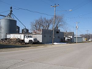
Orchard, Iowa, 2008
|
|

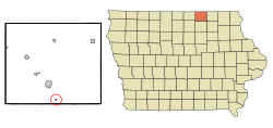
Location of Orchard, Iowa
|
|
| Country | United States |
| State | Iowa |
| County | Mitchell |
| Incorporated | July 10, 1913 |
| Government | |
| • Type | Mayor-Council |
| Area | |
| • Total | 0.10 sq mi (0.26 km2) |
| • Land | 0.10 sq mi (0.26 km2) |
| • Water | 0.00 sq mi (0.00 km2) |
| Elevation | 1,102 ft (336 m) |
| Population
(2024)
|
|
| • Total | 66 |
| • Density | 673.27/sq mi (258.82/km2) |
| Time zone | UTC-6 (Central (CST)) |
| • Summer (DST) | UTC-5 (CDT) |
| ZIP code |
50460
|
| Area code(s) | 641 |
| FIPS code | 19-59520 |
| GNIS feature ID | 0459886 |
Orchard is a small city in Mitchell County, Iowa, United States. In 2020, about 68 people lived there. It's a quiet place with a rich history.
Contents
History of Orchard
Orchard began in 1869. This was after the Illinois Central Railroad built its tracks through the area. The city was named after Moses Orchard, who was one of the first people to settle there.
Lithograph City: A Ghost Town Story
About two miles southwest of Orchard, there was once a town called Lithograph City. It was founded in the early 1900s. This town was special because it was next to quarries that dug up "lithographic limestone." This type of stone was used for a printing method called lithography.
Production of this stone was very busy during World War I. This was because it was hard to get German lithographic limestone then. In 1915, Lithograph City had 15 houses, a hotel, a dance hall, and even a museum.
After the war, people started using other ways to print. So, they didn't need as much stone. The town was later renamed Devonia. By 1938, the town was completely gone, becoming what we call a "ghost town."
Geography of Orchard
Orchard is located at coordinates 43.226995 degrees North and -92.774567 degrees West. This means it's in the northern part of the United States.
The United States Census Bureau says that Orchard covers a total area of about 0.09 square miles (0.26 square kilometers). All of this area is land, with no water.
Population Changes Over Time
| Historical populations | ||
|---|---|---|
| Year | Pop. | ±% |
| 1920 | 124 | — |
| 1930 | 158 | +27.4% |
| 1940 | 126 | −20.3% |
| 1950 | 114 | −9.5% |
| 1960 | 116 | +1.8% |
| 1970 | 115 | −0.9% |
| 1980 | 95 | −17.4% |
| 1990 | 93 | −2.1% |
| 2000 | 88 | −5.4% |
| 2010 | 71 | −19.3% |
| 1880 | 133 | +87.3% |
| 2020 | 68 | −48.9% |
| Source: and Iowa Data Center Source: |
||
The number of people living in Orchard has changed over many years. You can see how the population has grown and shrunk in the table above.
Orchard's Population in 2020
In 2020, the census counted 68 people living in Orchard. There were 29 households, which means 29 different homes where people lived. Out of these, 19 were families.
Most of the people in Orchard were White (94.1%). A small number were from other backgrounds. About 1.5% of the population identified as Hispanic or Latino.
The average age in Orchard was about 40.5 years old.
- About 32.4% of residents were under 20 years old.
- About 16.2% were between 25 and 44 years old.
- About 27.9% were between 45 and 64 years old.
- About 16.2% were 65 years old or older.
The city had slightly more males (51.5%) than females (48.5%).
Orchard's Population in 2010
Back in 2010, the census showed that 71 people lived in Orchard. There were 30 households.
- About 26.7% of homes had children under 18 living there.
- Many homes (46.7%) were married couples living together.
- Some homes (23.3%) had just one person living there.
The average age in 2010 was 42.2 years.
- About 21.1% of residents were under 18.
- About 29.6% were between 45 and 64.
- About 15.5% were 65 or older.
The city had slightly more males (50.7%) than females (49.3%) in 2010.
Education in Orchard
Students in Orchard attend schools within the Osage Community School District.
See also
 In Spanish: Orchard (Iowa) para niños
 | Valerie Thomas |
 | Frederick McKinley Jones |
 | George Edward Alcorn Jr. |
 | Thomas Mensah |

