Original Maryborough Town Site facts for kids
Quick facts for kids Original Maryborough Town Site |
|
|---|---|

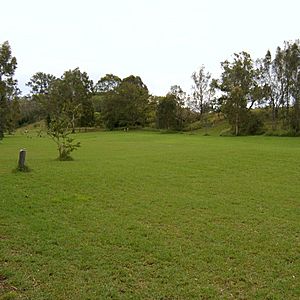
Looking NW across lower town site, from site of Furber's Inn, near Furber Street, 2005
|
|
| Location | Russell Street, Maryborough, Fraser Coast Region, Queensland, Australia |
| Official name: Original Maryborough Town Site | |
| Type | state heritage (archaeological) |
| Designated | 4 September 2007 |
| Reference no. | 602393 |
| Significant period | 1848 (fabric) & 1840s-1850s (historical use) |
| Lua error in Module:Location_map at line 420: attempt to index field 'wikibase' (a nil value). | |
The Original Maryborough Town Site is a special heritage place in Maryborough, Australia. It's an archaeological site where people lived between 1848 and 1855. This site is important because it shows us what early settlements in Queensland were like. It was added to the Queensland Heritage Register on 4 September 2007.
Contents
Discovering Maryborough's First Settlement
The first Maryborough town site was used from 1848 to 1855. It's about four kilometers northwest of the current city center, right on the south bank of the Mary River. This site is special because it's one of the few early Queensland towns that still looks much like it did back then. It can teach us a lot about life in the past.
Early Explorers and Settlers in Wide Bay
Free settlement in what is now Queensland began in 1840. In 1842, Andrew Petrie explored the Wide Bay area. He traveled up the Mary River, which was not yet named. Petrie and his group thought the area would be good for raising sheep.
One of the men, Captain Joliffe, worked for John Eales, a pastoralist. Eales tried to start a large sheep farm nearby, but it didn't work out. Still, other farmers soon came to the area. By 1847, many people wanted land here.
In July 1847, surveyor James Charles Burnett said the Wide Bay River was a good spot for a port. The river was then named Mary, after Lady Mary Lennox, the wife of Governor Fitzroy.
Setting Up the First Town Site
In September 1847, George Furber arrived from Ipswich. He set up a wool store, a small shop, and a wharf on the Mary River's south bank. The first wool was shipped out in December 1847.
However, Furber's site was on the wrong side of the river for the sheep farms. So, in June 1848, Edgar Thomas Aldridge and the Palmer brothers chose a new spot. This new site was on the north bank, right across from Furber's business. It was also in an open forest, which offered some safety.
The arrival of settlers often caused conflict with the traditional owners of the land. The Maryborough area was the traditional country of the Badtjala/Butchulla people.
Growing the Settlement
The Palmers and Aldridge opened inns, wool stores, and a wharf at the new site. This settlement was called Wide Bay. In December 1848, John Carne Bidwill, a government official, arrived. He set up a camp nearby on the south side of the river.
A post office opened on January 23, 1849, and the settlement became known as Maryborough. More inns were built, and Aldridge's "Bush Inn" became very popular. Because of all the activity, a Court of Petty Sessions was set up in January 1850.
By 1850, Maryborough was a busy center for trade. Wool, hides, timber, and tallow were shipped from here. Tallow came from boiling down sheep and was used to make soap in Britain. There were also sawmills to prepare timber for ships. Chinese vegetable gardens grew food like potatoes and cabbages near the settlement.
Moving to a New Location
Most settlers built their homes wherever they liked. But as more wool was shipped, the government decided to survey the area in 1850. Surveyor Hugh Roland Labatt arrived and thought the existing settlement wasn't the best spot for a port. He preferred a site where the river was deeper, which could handle bigger ships.
The settlers didn't agree with Labatt's decision. So, both sites were surveyed. Maryborough was officially declared a township in 1851. It had 299 people and 45 timber buildings, including a courthouse, church, and stores.
The first land blocks at the new site (near today's Queen's Park) were sold on January 14, 1852. Many people bought land, but they didn't move right away. They had already built homes and businesses at the old site.
As trade grew and larger ships came to the new wharves, it became clear that the old town (West Maryborough) had to move.
Abandoning the Old Site
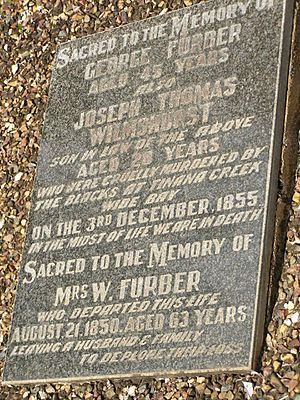
Another reason settlers left West Maryborough was increased conflict with Aboriginal people between 1852 and 1855. George Furber, an early settler, was killed in 1855. Aldridge, who had defended the old site, moved his business to East Maryborough in 1855. By 1856, West Maryborough was mostly empty.
The land then became farmland. In 1883, Aldridge built Baddow House nearby, which still stands today. He also created large gardens around his new home.
The wool trade continued to grow. Maryborough became an official port in 1859 and a municipality in 1861. Thousands of immigrants came to Queensland through the Port of Maryborough. The town also helped supply the goldfields discovered at Gympie in 1867.
What Remains Today
Maryborough is unique among early Queensland towns. Most other original town sites, like Brisbane and Ipswich, have been developed and are now busy cities. But the original Maryborough town site remains largely undeveloped.
In 1988, signs were put up to show where historical buildings once stood. Even though some parts of the site are now private land, most of the original building locations are still undeveloped. Flooding over the years has covered much of the old settlement with silt, which has helped protect archaeological items.
Some parts of the site were used for sugar cane farming in the early 1900s. A sewerage treatment plant was built near Aldridge's inn but was later removed. Today, the Fraser Coast Regional Council looks after the site and helps people learn about its history.
Exploring the Original Town Site
The original Maryborough town site stretches along the northern bank of the Mary River. You can find signs of the early settlement here, like old graves, sawpits, and stone building foundations. The site has open parkland, grassy fields, and thick vegetation.
The main entrance is along Aldridge Street. This road didn't exist when the town was first settled. The park area near Alice and Aldridge Streets was originally the cemetery.
Graves and Old Crossings
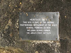
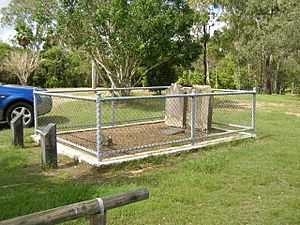
The park on the northwest side of Aldridge Street has the marked graves of George Furber and Joseph Wilmshurst. There are also other identified graves and many depressions that suggest unmarked graves. Two more marked graves are on the other side of Aldridge Street.
Further down Aldridge Street, you'll find the remains of an old creek crossing. These are mostly pieces of old wooden timbers in the creek bed. The large park on this side of Aldridge Street was once the site of Chinese gardens.
Muddy Creek and River Terraces
Muddy Creek flows through the southeast part of the site and joins the Mary River. East of the creek's mouth, you can see bamboo and old trees. A small stone and concrete jetty stands near where Furber's inn once was.
Northwest of Muddy Creek, the land rises to a flat area called a river terrace, where Furber Street is located. Much of the original town spread along a ridge here, with most buildings on the southwest side of Queen Street.
The lower river terrace is covered with over a meter of flood-deposited soil. This soil has helped protect old archaeological items. The topsoil on the main ridge has been worn away in some places, but you can still see shale and stone. Some stone foundations remain at the site of Aldridge's first inn.
Most of the old town site is now open parkland or grassy fields. There isn't much left above ground, but markers help you understand the town's layout. Features like the marked graves and sawpits are still clear to see.
Why This Site is Important
The Original Maryborough Town Site is important for understanding Queensland's history.
Showing Queensland's Early Development
This site shows how early settlements grew in Queensland. It highlights the need for a safe port for farmers and timber workers in the 1840s. The site was used from 1848 and mostly left by 1856. Its abandonment shows the need for a better port location.
A Rare Glimpse into the Past
This site is unique among Queensland's early towns. Of all the towns that existed by 1859, Maryborough is the only one where most of its original town site is still open and undeveloped. This makes it a rare and special place.
Learning from Archaeology
Because the site was abandoned and hasn't been built on much, it has great potential for archaeological discoveries. Regular floods have covered the lower areas with a protective layer of soil. This means that digging here could uncover important new information about daily life in an early Queensland settlement.
Archaeological digs could reveal details about the people who lived there, their buildings, burial sites, old streets, and industrial areas like sawpits and wharves. All this information can help us get a more complete picture of this important early Queensland settlement.


