Orleans Canal facts for kids
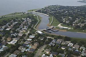
The Orleans Canal is an important drainage canal in New Orleans, Louisiana. It works with the 17th Street Canal and the London Avenue Canal. Together, these are known as the New Orleans Outfall Canals.
This canal is about 2 kilometers (1.2 miles) long. It runs next to City Park, through the Lakeview and Lakeshore areas. It then flows into Lake Pontchartrain. The canal is a key part of the system that pumps rainwater out of the city streets and into the lake. People have also called it the Orleans Avenue Canal, the Orleans Outfall Canal, the Orleans Tail Race, and long ago, the Girod Canal.
Contents
How the Orleans Canal Was Built
The very first version of the Orleans Canal was different from what we see today. It was a simple ditch dug in the 1830s. This ditch ran alongside Orleans Avenue, from the Tremé neighborhood to Bayou St. John.
Early Drainage Efforts
This early ditch was part of a city plan by engineer George T. Dunbar. A special machine called the "Bienville Drainage Machine" was built. It was a large paddle-wheel powered by a steam engine. This machine pushed water from the Orleans Canal towards the lake. This was likely one of the first mechanical pumps used to remove water from New Orleans streets. Dunbar had bigger plans for city drainage. However, a money crisis in 1837 stopped most of these plans for many years.
Expanding the Canal
The canal was made bigger in the 1870s as New Orleans grew. In 1871, drainage improvements changed the canal's path. It was extended to reach Lake Pontchartrain instead of Bayou St. John.
A company called the Canal Street, City Park, and Lake Railroad Company was started in 1873. Their railway line was finished by 1877. The railway ran from the main part of the city, which was close to the Mississippi River. It had a stop at City Park. Then, it curved at the Lakefront and ended at Spanish Fort Amusement Park. Much of the railway followed the straight path of the canal. The canal was dug deeper, and the dirt removed was used to build up the railway's path through the low, swampy land.
Even though some city maps from the 1800s showed streets in this area, it stayed a swamp. There was little development there until the mid-1900s. Back then, the canal's main job was to remove water from the developed areas closer to the city, not from the swampy land along most of its length.
Improvements in the 1900s
The early 1900s brought more improvements. A second pumping station was added closer to the lake, near where I-610 is today. In 1906, electric streetcars replaced the steam locomotive on the railway line. Also, a much better drainage pumping system was put in place. This system was designed by A. Baldwin Wood.
Starting in the late 1920s, the Lake Pontchartrain shoreline was extended. New levees were built along the lake. The part of the canal closer to the city was covered over. It became an underground drainage system. The levees along the rest of the canal were made taller. This happened as the former swampy area was developed after World War II. The land on one side became an extension of City Park. The land on the other side became the Lakeview neighborhood. The water level in this part of the canal was, and often still is, higher than the surrounding streets.
The Canal After Hurricane Katrina
During Hurricane Katrina in 2005, the levees and floodwalls of the Orleans Canal did not break. The Army Corps of Engineers later found out why. There was an unplanned 100-foot-long "spillway" near Pump Station No. 7. This was a section of an older wall that was much lower than the newer floodwalls next to it.
The Unintended Spillway
This unplanned spillway was located under a bridge for Interstate-610. The top of the dirt levee here was about 5 to 6 feet lower than the concrete floodwalls next to it. This gap allowed floodwaters to pour through. This helped to lower the water levels inside the canal.
This gap was a problem for the Orleans Levee Board and the New Orleans Sewerage & Water Board. If the walls of the 17th Street Canal and the London Avenue Canal had not broken, this spillway could have caused significant flooding. However, the major breaks in the 17th Street and London Avenue Canals made this specific issue less important in the end.
It is important to know that all three canals were supposed to be built to the same standards before Hurricane Katrina. They all faced very similar conditions during the storm.
New Protection Standards
After Hurricane Katrina, the government ordered new hurricane protection. This protection needed to be strong enough to handle a "100-year storm." This means a storm that has a 1% chance of happening each year. To meet this goal, the Army Corps of Engineers decided to build new pumping stations and permanent closures on all three New Orleans Outfall Canals.
 | James B. Knighten |
 | Azellia White |
 | Willa Brown |


