Ormsby, Minnesota facts for kids
Quick facts for kids
Ormsby, Minnesota
|
|
|---|---|

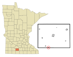
Location in Watonwan County and the state of Minnesota
|
|
| Country | United States |
| State | Minnesota |
| Counties | Watonwan, Martin |
| Government | |
| • Type | Mayor – Council |
| Area | |
| • Total | 0.35 sq mi (0.92 km2) |
| • Land | 0.35 sq mi (0.92 km2) |
| • Water | 0.00 sq mi (0.00 km2) |
| Elevation | 1,204 ft (367 m) |
| Population
(2020)
|
|
| • Total | 118 |
| • Density | 334.28/sq mi (128.89/km2) |
| Time zone | UTC-6 (Central (CST)) |
| • Summer (DST) | UTC-5 (CDT) |
| ZIP code |
56162
|
| Area code(s) | 507 |
| FIPS code | 27-48562 |
| GNIS feature ID | 2396080 |
Ormsby is a small city in the state of Minnesota, United States. It is located in both Watonwan and Martin counties. In 2020, about 118 people lived there. Ormsby is found between the cities of St. James and Sherburn, right on Minnesota State Highway 4.
Contents
History of Ormsby
Ormsby was officially planned and laid out in 1899. This process is called platting. The city was named after a person known as "Colonel Ormsby" from Emmetsburg, Iowa.
A post office started operating in Ormsby in the year 1900. Just two years later, in 1902, Ormsby became an incorporated city. This means it became an official town with its own local government.
Geography and Location
Ormsby is located right on the border between two counties. Watonwan County is to the north, and Martin County is to the south.
Minnesota State Highway 4 goes through the eastern part of the city. If you go north on this highway for about 10 miles, you will reach St. James. St. James is the main city, or county seat, for Watonwan County. Going south for about 14 miles on the same highway leads to Sherburn. Fairmont, the county seat for Martin County, is about 25 miles to the southeast.
The U.S. Census Bureau states that Ormsby covers a total area of 0.35 square miles (0.92 square kilometers). All of this area is land.
Population and People
This section talks about the number of people living in Ormsby over the years. This is called demographics.
| Historical population | |||
|---|---|---|---|
| Census | Pop. | %± | |
| 1910 | 112 | — | |
| 1920 | 115 | 2.7% | |
| 1930 | 107 | −7.0% | |
| 1940 | 183 | 71.0% | |
| 1950 | 190 | 3.8% | |
| 1960 | 221 | 16.3% | |
| 1970 | 199 | −10.0% | |
| 1980 | 181 | −9.0% | |
| 1990 | 159 | −12.2% | |
| 2000 | 154 | −3.1% | |
| 2010 | 131 | −14.9% | |
| 2020 | 118 | −9.9% | |
| U.S. Decennial Census | |||
Ormsby's Population in 2010
According to the census from 2010, there were 131 people living in Ormsby. These people lived in 65 different homes, and 41 of these were families.
The city had about 374 people per square mile. There were 68 housing units in total. Most of the people living in Ormsby were White (91.6%). Some were Native American (7.6%), and a small number were of two or more races (0.8%). About 1.5% of the population identified as Hispanic or Latino.
Out of the 65 homes, 13.8% had children under 18 living there. More than half (53.8%) were married couples living together. A small number of homes had a single parent. About 33.8% of all homes had only one person living there. About 20% of homes had someone 65 years or older living alone. The average number of people in a home was 2.02, and the average family size was 2.51.
The average age of people in Ormsby was 52.3 years old. About 14.5% of residents were under 18. About 7.7% were between 18 and 24. Many residents (36.7%) were between 45 and 64 years old. About 26% of the people were 65 years or older. The city had slightly more females (51.9%) than males (48.1%).
See also
 In Spanish: Ormsby (Minnesota) para niños
 | Misty Copeland |
 | Raven Wilkinson |
 | Debra Austin |
 | Aesha Ash |

