
Ortega (Jacksonville) facts for kids
Quick facts for kids |
|
|
Old Ortega Historic District
|
|
 |
|

Location in Florida

Location in the United States
|
|
| Location | Jacksonville, Florida, US |
|---|---|
| Area | 4500 acres (18 km2) |
| NRHP reference No. | 04000682 |
| Added to NRHP | July 14, 2004 |
Ortega is a well-known neighborhood in Jacksonville, Florida, US. It sits on a piece of land that sticks out into the water, south of downtown Jacksonville. This area is known for being one of the wealthiest neighborhoods in Jacksonville. It is also home to many beautiful old houses and buildings.
The Ortega area is surrounded by the St. Johns River and the Ortega River. A main road, Roosevelt Boulevard (U.S. Route 17), cuts through it. The part of Ortega east of Roosevelt Boulevard is called Old Ortega. The area to the west is known as Ortega Forest. In 2004, a part of Old Ortega became the Old Ortega Historic District. This means its important history and buildings are protected.
Contents
A Look Back at Ortega's History
Ortega's story began in 1763, after Spain gave Florida to England. By 1780, a man named Colonel Daniel McGirtt lived in the area. He was involved in conflicts during that time. Today, a road and a park in Ortega are still named after him.
In 1902, a famous businessman named J. Pierpont Morgan helped fund the development of modern-day Ortega. By 1908, the Ortega Company finished building a wooden bridge across the Ortega River. This bridge connected Ortega to Avondale. A clubhouse was also built, designed by the famous architect Henry Bacon. He also designed the Lincoln Memorial in Washington D.C. The biggest building boom happened in the 1920s. Since then, Ortega has remained a neighborhood with many successful business people and long-standing families.
Ortega's Location and Features
The land where Ortega is located was once an island. A land bridge was built at its southern end, which is now part of Roosevelt Boulevard. This road is also part of U.S. Route 17. The St. Johns River is to the east of Ortega, and the smaller Ortega River is to the north and west.
Roosevelt Boulevard divides Ortega into two main parts. The older area to the east is called "Ortega" or "Old Ortega." The newer areas to the west are known as "Ortega Forest." You can also reach Ortega by crossing the Ortega River Bridge. This bridge was built in 1927.
On July 14, 2004, a part of Old Ortega was named the Old Ortega Historic District. This district is east of U.S. 17 and north of Verona Boulevard. Ortega Boulevard is the main road through this historic area. It covers a large space and includes 597 historic buildings.
Exploring the Ortega Neighborhood
Ortega has different areas, each with its own feel. Along the riverfront, you'll find very large, expensive homes. Ortega Point has older wooden and Tudor-style houses around Bettes Park. The historic district features more modest wooden homes from the early 1900s. Ortega Terrace, in the southern part of the area, has large stone and brick houses in various styles.
The neighborhood has many parks. Local residents have even set up special funds to help keep these parks beautiful.
Venetia Development Gates
The Venetia gates mark the entrance to Venetia. This area was planned in 1925 by Colonel Raymond C. Turck. He wanted to create a community inspired by the canals of Venice, Italy. However, his plans were not fully built due to a real estate slowdown in 1926. An old resident shared that in the 1930s, there were only 32 houses there. Ortega Boulevard was a brick road that went all the way to Green Cove Springs. The gates had a special electric light in the middle, which has since been restored.
Schools and Community Life
Two schools serve the Ortega area: Ortega Elementary School and St. Mark's Episcopal Day School. Many children also go to Stockton Elementary School in nearby Ortega Forest. Many kids in the neighborhood walk or bike to school. Ortega is known for its strong family-focused community. Many teenagers from the area attend private schools or special "magnet" high schools nearby.
The streets in Ortega are laid out in a grid pattern. Many street names follow themes. One part of the historic district has names of Native American tribes. Another section uses names of famous universities. A third section has names of different types of columns, like Doric or Ionic.
The largest churches in the area are St. Mark's Episcopal Church and United Methodist Church.
Clubs and Activities
Many Ortega residents are members of either the Florida Yacht Club or Timuquana Country Club. Because it's so close to the water, many people enjoy boating or sailing. A famous New York businessman, William Astor, helped start the Florida Yacht Club. There's even a room named after him in the clubhouse. The golf courses at Timuquana were designed by a very well-known golf architect, Donald Ross.
Huckins Yachts
Huckins Yachts are built just across the Ortega River from the neighborhood. This company started over 80 years ago. The very first Huckins yacht was sold to David M. Goodrich of the B.F. Goodrich Rubber Company. Many Ortega residents own a Huckins Yacht, which can range from 35 feet to almost 100 feet long. Huckins yachts are also popular in places like Fort Lauderdale, Florida and Newport, Rhode Island. During World War II, Huckins also built many PT boats for the U.S. Navy.
Well-Known People from Ortega
- Henry Bacon, who designed the Lincoln Memorial
- Jack del Rio, a former coach for the Jacksonville Jaguars
- David Duval, a professional golfer
- John Milton Bryan Simpson, a former federal judge
- Bill Terry, a former Major League baseball player and a member of the Baseball Hall of Fame
Images for kids
-
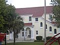
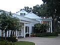
Front View of Ortega Elementary.
-
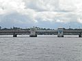
View of the 1928 Ortega Drawbridge, one of the busiest drawbridges left in the country.
-
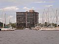
View of some condos along the Ortega River from Ortega during the winter.
-
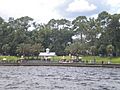
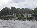
View of Stockton Park in Ortega from St. Johns River.
-
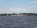
View of the Florida Yacht Club in the Ortega neighborhood on a day when the St. Johns River was choppy with windswept waves. The current clubhouse dates to 1928.
-
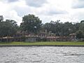
A side view of the Timuquana Country Club. The links were designed by Donald Ross.
-
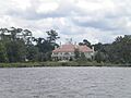
A view from the St. Johns River of the 1925 Mediterranean mansion Los Cedros designed by famed architect Marion Sims Wyeth of Palm Beach.
-
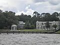
Old Ortega Riverfront mansions.
-
More Ortega riverfront mansions.
-
Another fairly new Ortega riverfront mansion.


