Osnabrück (district) facts for kids
Quick facts for kids
Osnabrück
|
||
|---|---|---|
|
||
 |
||
| Country | ||
| State | Lower Saxony | |
| Capital | Osnabrück | |
| Area | ||
| • Total | 2,122 km2 (819 sq mi) | |
| Population
(2003)
|
||
| • Total | 357,300 | |
| • Density | 168.38/km2 (436.10/sq mi) | |
| Time zone | UTC+1 (CET) | |
| • Summer (DST) | UTC+2 (CEST) | |
| Vehicle registration | OS | |
| Website | http://www.lkos.de | |
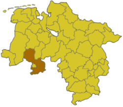
The Osnabrück district is a region in Lower Saxony, Germany. It's like a county in other countries. This district is close to other areas in Lower Saxony, such as Emsland, Cloppenburg, Vechta, and Diepholz. It also borders parts of the state of North Rhine-Westphalia, including the districts of Minden-Lübbecke, Herford, Gütersloh, Warendorf, and Steinfurt. The big city of Osnabrück is also right next to the district.
Contents
History of Osnabrück District
The Osnabrück district we know today is very similar to an old area called the Prince-Bishopric of Osnabrück. This special region existed until the year 1803. Back then, it was ruled by a prince-bishop, who was both a religious leader and a ruler of the land.
When many church-ruled states in Germany were ended, Osnabrück became part of the Kingdom of Hanover. Later, in 1866, the Kingdom of Hanover became part of Prussia.
The modern Osnabrück district was officially created in 1972. This happened when four older districts – Osnabrück, Melle, Bersenbrück, and Wittlage – joined together.
Geography of Osnabrück
The Osnabrück district has a unique landscape. You'll find two main mountain ranges here. In the northern part, there's the Wiehengebirge (say: VEE-hen-geh-beer-guh). In the south, you'll see the northern edges of the Teutoburg Forest (say: TOY-toh-burg).
These two mountain chains form a kind of circle around the central Osnabrück city. This makes the area quite scenic with hills and forests.
Symbols of the District
Coat of Arms
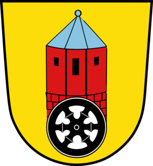
The coat of arms (like a special symbol or badge) for the Osnabrück district tells a story. It shows the Bennoturm, which means "Benno's Tower." This tower is part of a castle in Bad Iburg. It was used as a strong fortress by the bishops until 1673.
You can also see a wheel on the coat of arms. This wheel is a very old symbol for the City of Osnabrück itself. It represents the city's history and importance.
Towns and Villages in Osnabrück District
The Osnabrück district is made up of many different cities and smaller communities. These are organized into different types of areas.
Cities
- Bad Iburg
- Bramsche
- Dissen
- Georgsmarienhütte
- Melle
Free Municipalities
These are towns and villages that manage themselves directly.
- Bad Essen
- Bad Laer
- Bad Rothenfelde
- Belm
- Bissendorf
- Bohmte
- Glandorf
- Hagen
- Hasbergen
- Hilter
- Ostercappeln
- Wallenhorst
Samtgemeinden (Joint Municipalities)
A Samtgemeinde is a group of smaller towns and villages that work together on some services. Each group has a main town where their offices are located.
- 1. Artland
- Badbergen
- Menslage
- Nortrup
- Quakenbrück (This is the main town and also a city)
- 2. Bersenbrück
- Alfhausen
- Ankum
- Bersenbrück (This is the main town and also a city)
- Eggermühlen
- Gehrde
- Kettenkamp
- Rieste
- 3. Fürstenau
- Berge
- Bippen
- Fürstenau (This is the main town and also a city)
- 4. Neuenkirchen
- Merzen
- Neuenkirchen (This is the main town)
- Voltlage
See also
 In Spanish: Distrito de Osnabrück para niños
 | Misty Copeland |
 | Raven Wilkinson |
 | Debra Austin |
 | Aesha Ash |


