
Ostvorpommern facts for kids
Quick facts for kids
Ostvorpommern
|
|
|---|---|
 |
|
| Country | |
| State | Mecklenburg-Vorpommern |
| Capital | Anklam |
| Area | |
| • Total | 1,910 km2 (740 sq mi) |
| Population
(2001)
|
|
| • Total | 113,623 |
| • Density | 59.49/km2 (154.1/sq mi) |
| Time zone | UTC+1 (CET) |
| • Summer (DST) | UTC+2 (CEST) |
| Vehicle registration | OVP |
| Website | http://www.kreis-ovp.de |
Ostvorpommern was a special area called a Kreis (which means district in German). It was located in the eastern part of Mecklenburg-Vorpommern, a state in Germany. The famous Hanseatic city of Greifswald was surrounded by this district, but it was not actually part of Ostvorpommern itself.
History
This district was created on June 12, 1994. It was formed by joining three older districts: Anklam, Greifswald, and Wolgast. This change helped organize the region better.
Coat of Arms
The coat of arms for Ostvorpommern shows a griffin. A griffin is a mythical creature with the body of a lion and the head and wings of an eagle. This griffin is a symbol often used in the region of Pomerania.
Towns and Municipalities
Ostvorpommern had different types of towns and communities. Some towns were "Amt-free," meaning they managed themselves without belonging to a larger group called an Amt. An Amt is like a local administrative union that helps smaller towns and villages work together.
The main "Amt-free" towns were:
- Anklam
- Heringsdorf
The district also had several Ämter (plural of Amt), which included many smaller towns and villages. Some of the important towns that were seats (main towns) of these Ämter included:
- Wolgast (in Amt Am Peenestrom)
- Spantekow (in Amt Anklam-Land)
- Neuenkirchen (in Amt Landhagen)
- Lubmin (in Amt Lubmin)
- Zinnowitz (in Amt Usedom-Nord)
- Usedom (in Amt Usedom-Süd)
- Züssow (in Amt Züssow)
See also
 In Spanish: Distrito de Pomerania Oriental para niños
Images for kids
-
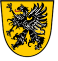
The coat of arms for Ostvorpommern, featuring a griffin.

