Ottertail, Minnesota facts for kids
Quick facts for kids
Ottertail
|
|
|---|---|

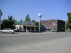
Looking southwest along Main Street (State Hwy. 108)
|
|

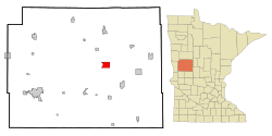
Location of Ottertail, Minnesota
|
|
| Country | United States |
| State | Minnesota |
| County | Otter Tail |
| Founded | 1903 |
| Area | |
| • Total | 5.97 sq mi (15.47 km2) |
| • Land | 4.28 sq mi (11.08 km2) |
| • Water | 1.70 sq mi (4.39 km2) |
| Elevation | 1,355 ft (413 m) |
| Population
(2020)
|
|
| • Total | 629 |
| • Estimate
(2021)
|
656 |
| • Density | 147.07/sq mi (56.79/km2) |
| Time zone | UTC-6 (CST) |
| • Summer (DST) | UTC-5 (CDT) |
| ZIP code |
56571
|
| Area code(s) | 218 |
| FIPS code | 27-49210 |
| GNIS feature ID | 2396107 |
Ottertail is a small city located in Otter Tail County, Minnesota, in the United States. In 2020, about 629 people lived there.
Contents
A Look Back in Time
Ottertail was officially planned and mapped out in 1903. It got its name from the beautiful Otter Tail Lake nearby. Interestingly, a place called "Otter Tail" City was even mentioned in the United States Census way back in 1860!
Where is Ottertail?
Ottertail is located in Minnesota. The United States Census Bureau says the city covers about 5.10 square miles (13.21 square kilometers). Most of this area, about 4.28 square miles (11.08 square kilometers), is land. The rest, about 0.82 square miles (2.12 square kilometers), is water.
Two main roads, Highway 78 and Highway 108, pass through the community.
Weather in Ottertail
Ottertail has a humid continental climate. This means it has four distinct seasons. Winters are long and very cold, with temperatures often below zero degrees Fahrenheit at night. Summers are warm, but they often have thunderstorms and rain.
| Climate data for Ottertail, Minnesota, 1991–2020 normals, extremes 1961–present | |||||||||||||
|---|---|---|---|---|---|---|---|---|---|---|---|---|---|
| Month | Jan | Feb | Mar | Apr | May | Jun | Jul | Aug | Sep | Oct | Nov | Dec | Year |
| Record high °F (°C) | 56 (13) |
59 (15) |
73 (23) |
94 (34) |
94 (34) |
98 (37) |
102 (39) |
101 (38) |
97 (36) |
91 (33) |
72 (22) |
57 (14) |
102 (39) |
| Mean maximum °F (°C) | 40.5 (4.7) |
44.3 (6.8) |
58.1 (14.5) |
74.2 (23.4) |
84.8 (29.3) |
88.2 (31.2) |
89.8 (32.1) |
89.0 (31.7) |
84.7 (29.3) |
76.8 (24.9) |
58.6 (14.8) |
42.7 (5.9) |
91.9 (33.3) |
| Mean daily maximum °F (°C) | 17.4 (−8.1) |
23.4 (−4.8) |
35.9 (2.2) |
51.6 (10.9) |
64.8 (18.2) |
74.5 (23.6) |
78.6 (25.9) |
77.3 (25.2) |
68.9 (20.5) |
53.8 (12.1) |
36.6 (2.6) |
23.4 (−4.8) |
50.5 (10.3) |
| Daily mean °F (°C) | 7.7 (−13.5) |
12.5 (−10.8) |
25.5 (−3.6) |
40.6 (4.8) |
54.5 (12.5) |
65.1 (18.4) |
69.4 (20.8) |
68.0 (20.0) |
58.9 (14.9) |
44.6 (7.0) |
29.0 (−1.7) |
15.2 (−9.3) |
40.9 (5.0) |
| Mean daily minimum °F (°C) | −2.0 (−18.9) |
1.6 (−16.9) |
15.1 (−9.4) |
29.7 (−1.3) |
44.2 (6.8) |
55.8 (13.2) |
60.2 (15.7) |
58.7 (14.8) |
49.0 (9.4) |
35.4 (1.9) |
21.3 (−5.9) |
7.1 (−13.8) |
31.3 (−0.4) |
| Mean minimum °F (°C) | −25.8 (−32.1) |
−21.8 (−29.9) |
−10.5 (−23.6) |
14.6 (−9.7) |
30.7 (−0.7) |
43.6 (6.4) |
50.4 (10.2) |
48.8 (9.3) |
35.7 (2.1) |
22.7 (−5.2) |
3.1 (−16.1) |
−15.7 (−26.5) |
−28.6 (−33.7) |
| Record low °F (°C) | −40 (−40) |
−45 (−43) |
−33 (−36) |
−7 (−22) |
18 (−8) |
33 (1) |
37 (3) |
35 (2) |
19 (−7) |
10 (−12) |
−21 (−29) |
−38 (−39) |
−45 (−43) |
| Average precipitation inches (mm) | 0.62 (16) |
0.62 (16) |
1.24 (31) |
2.23 (57) |
3.43 (87) |
4.76 (121) |
4.27 (108) |
3.29 (84) |
3.16 (80) |
2.69 (68) |
1.07 (27) |
0.79 (20) |
28.17 (715) |
| Average precipitation days (≥ 0.01 in) | 6.3 | 5.9 | 7.1 | 8.3 | 10.6 | 11.8 | 12.0 | 9.4 | 9.0 | 10.0 | 7.4 | 7.3 | 105.1 |
| Source 1: NOAA | |||||||||||||
| Source 2: National Weather Service | |||||||||||||
Population of Ottertail
The number of people living in Ottertail has changed over the years. Here's how the population has grown:
| Historical population | |||
|---|---|---|---|
| Census | Pop. | %± | |
| 1910 | 176 | — | |
| 1920 | 223 | 26.7% | |
| 1930 | 221 | −0.9% | |
| 1940 | 254 | 14.9% | |
| 1950 | 237 | −6.7% | |
| 1960 | 164 | −30.8% | |
| 1970 | 180 | 9.8% | |
| 1980 | 239 | 32.8% | |
| 1990 | 313 | 31.0% | |
| 2000 | 451 | 44.1% | |
| 2010 | 572 | 26.8% | |
| 2020 | 629 | 10.0% | |
| 2021 (est.) | 656 | 14.7% | |
| U.S. Decennial Census 2020 Census |
|||
People Living in Ottertail (2010)
In 2010, there were 572 people living in Ottertail. These people made up 245 households, with 171 of them being families. The city had about 133 people per square mile.
Most people in Ottertail were White (99.0%). A small number were Native American (0.2%) or from two or more races (0.9%). About 0.9% of the population was Hispanic or Latino.
About 22% of households had children under 18 living with them. More than half (57.1%) were married couples. The average household had 2.33 people, and the average family had 2.75 people.
The average age in the city was 47.7 years old.
- 18.2% of residents were under 18.
- 5.4% were between 18 and 24.
- 21.4% were between 25 and 44.
- 35.2% were between 45 and 64.
- 19.6% were 65 years or older.
The population was almost evenly split between males (51.2%) and females (48.8%).
See also
 In Spanish: Ottertail (Minnesota) para niños
 | Victor J. Glover |
 | Yvonne Cagle |
 | Jeanette Epps |
 | Bernard A. Harris Jr. |

