
Owendoher River facts for kids
Quick facts for kids Owendoher River |
|
|---|---|

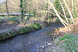
Owendoher River near Cruagh Wood
|
|
| Physical characteristics | |
| Main source | Glendoo Mountain and Kilakee Mountain, County Dublin |
| River mouth | River Dodder near Rathfarnham, ultimately Dublin Bay (River Liffey) |
| Basin features | |
| River system | River Liffey via River Dodder system |
| Tributaries |
|
The Owendoher River is a small but important river in southern County Dublin, Ireland. In Irish, it's called An Dothra Bheag, which means "The Little Dodder." This river is the biggest stream that flows into the River Dodder, and it's also part of the larger River Liffey system.
Contents
The Owendoher River's Journey
The Owendoher River starts high up in the mountains of County Dublin. It actually begins as two main streams.
Where the River Starts
The first and larger stream flows from the Glendoo and Glencullen valleys. The second stream is formed from two smaller ones. One of these is sometimes called Kilakee Stream, coming from the slopes of Killakee Mountain. The other is Glendoo Stream, which flows from the west side of Glendoo Mountain.
These two main branches meet near Rockbrook Cemetery. Another small stream from Woodbrook and Piperstown also joins them there. From this point, the Owendoher River flows north towards Ballyboden.
Journey to the Dodder
As the river continues its journey, it reaches Rathfarnham. Along the way, it receives water from another stream called the Whitechurch Stream.
Finally, the Owendoher River joins the River Dodder. This meeting point is just south of Bushy Park, near where the old settlement of Butterfield used to be. This is also just southwest of Rathfarnham village.
Bridges Along the Way
Since the Owendoher River flows through many developed areas, especially in its lower parts, it passes under lots of bridges. These bridges help roads and paths cross over the river.
Some of the many bridges include:
- Road bridges like the one on Dodder View Road (part of the R112) and Butterfield Avenue (part of the R114).
- Pedestrian bridges, which are just for people walking, connecting parks and roads.
- Service road bridges that lead to housing areas like Otterbrook and Boden Wood.
- The river also flows under the busy M50 motorway.
- There are even some older, unused bridges along its path.
Gallery
- Photos of the Owendoher River
-
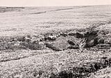
The river's source on Glendoo Mountain.
-
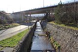
The Owendoher running under the M50 motorway.
-
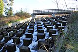
Stone structures in the Owendoher near the M50.
-
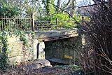
Abandoned bridge near Ballyroan.
-
The Owendoher meets the River Dodder.


