Oxbow Creek facts for kids
Quick facts for kids Oxbow Creek |
|
|---|---|

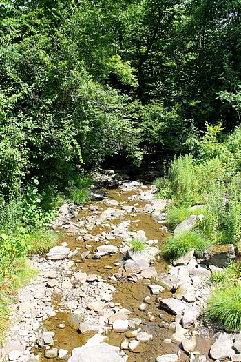
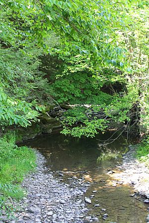
Oxbow Creek looking downstream
|
|
| Other name(s) | Hortons Creek |
| Physical characteristics | |
| Main source | Oxbow Lake in Lemon Township, Wyoming County, Pennsylvania between 1,040 and 1,060 feet (317 and 323 m) |
| River mouth | Tunkhannock Creek in Lemon Township, Wyoming County, Pennsylvania at East Lemon 650 ft (200 m) 41°35′15″N 75°51′41″W / 41.58739°N 75.86146°W |
| Length | 2.5 mi (4.0 km) |
| Basin features | |
| Progression | Tunkhannock Creek → Susquehanna River → Chesapeake Bay |
| Basin size | 8.56 sq mi (22.2 km2) |
| Tributaries |
|
| Other tributaries | Oxbow Inlet |
Oxbow Creek, also known as Hortons Creek, is a small river in Wyoming County, Pennsylvania. It flows into Tunkhannock Creek. The creek is about 2.5 miles (4.0 km) long. It runs through Lemon Township.
The area of land that drains into the creek, called its watershed, is about 8.56 square miles (22.2 km2). Oxbow Creek has two smaller streams that flow into it: Horton Creek and Oxbow Inlet. The creek is considered healthy and clean.
The ground around the creek is made up of different types of soil and rock. These include glacial till, river deposits, and solid bedrock. People started settling near the creek's mouth before the year 1800. In the 1800s, some mills were built along its banks. Many bridges have also been built over the creek. The creek's watershed is a special place for coldwater fish and fish that travel long distances.
Contents
Where Does Oxbow Creek Flow?
Oxbow Creek starts in Oxbow Lake in Lemon Township. Another stream, Oxbow Inlet, flows into Oxbow Lake. From the lake, Oxbow Creek flows east, then turns south for a short distance. It then enters a valley.
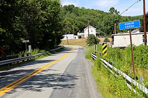
The creek continues flowing east through the valley for a while. It then meets its tributary, Horton Creek, which flows in from the left side. After this, Oxbow Creek turns south-southeast. It then turns south again. Finally, it flows southeast for a short distance, crossing Pennsylvania Route 92. It then joins Tunkhannock Creek.
Oxbow Creek meets Tunkhannock Creek about 8.70 miles (14.0 km) before Tunkhannock Creek reaches its own mouth.
Streams That Join Oxbow Creek
Oxbow Creek has two named streams that flow into it. These are Oxbow Inlet and Horton Creek.
Oxbow Inlet joins Oxbow Creek about 2.79 miles (4.49 km) upstream from its mouth. This happens near a place called St. Andrews Camp. The land area that drains into Oxbow Inlet is about 1.79 square miles (4.6 km2).
Horton Creek joins Oxbow Creek about 1.50 miles (2.41 km) upstream from its mouth. This is also close to St. Andrews Camp. The land area that drains into Horton Creek is about 3.60 square miles (9.3 km2).
Is the Water Clean?
Oxbow Creek is not listed as an "impaired waterbody." This means that the water quality in the creek is good. It meets the standards for healthy water.
What is the Land Like Around the Creek?
The land around the mouth of Oxbow Creek is about 650 feet (200 m) above sea level. Where the creek begins, its source, the elevation is higher. It is between 1040 and 1060 feet (317 and 323 m) above sea level.
The ground near the creek's mouth is mostly made of alluvium. Alluvium is a type of soil left behind by flowing water. Further upstream, you can find alluvium, but also a type of soil called till. This till is from the Wisconsinan Ice Age. There is also solid bedrock made of sandstone and shale.
Near the upper parts of the creek, the ground is mainly Wisconsinan Till. There is also some alluvium. Near where Horton Creek joins, there is a patch of Wisconsinan Ice-Contact Stratified Drift. This is material left by glaciers.
The Creek's Watershed
The watershed of Oxbow Creek covers an area of about 8.56 square miles (22.2 km2). A watershed is all the land where water drains into a particular river or creek.
The mouth of the creek is in a map area called the Factoryville quadrangle. However, the source of the creek is in the Tunkhannock quadrangle. The mouth of the creek is located in a place called East Lemon.
Oxbow Creek is important for aquatic life. This means it is a good habitat for fish and other water creatures.
In 2011, during August and September, Oxbow Creek had big floods. These floods caused the creek banks to wear away, which is called erosion. To help protect the banks from future floods, large rocks were placed along the creek. These rocks are called riprap.
A Look at the Creek's History
Oxbow Creek was officially added to the Geographic Names Information System on August 2, 1979. Its special identification number is 1193074. The creek is also known by its other name, Hortons Creek. This name was mentioned in a book from 1883 about the geology of the Susquehanna River region.
Early settlers came to Lemon Township from Orange County, New York, before the year 1800. They settled near the mouth of Oxbow Creek. During the 1800s, several sawmills were built along the creek. These mills used the creek's water power. However, in 1868, heavy rains caused floods that destroyed most of the dams for these mills. In 1879, a man named W.S. Shaw built a new saw and lath mill on the creek.
Many bridges have been built over Oxbow Creek. For example, three bridges carrying State Route 1009 were built in 1948. Two of these are steel bridges, and one is a concrete culvert bridge. Their lengths are about 38.1 feet (11.6 m), 38.1 feet (11.6 m), and 21.0 feet (6.4 m).
Another concrete culvert bridge for State Route 1009 was built in 1949. It is about 33.1 feet (10.1 m) long. In 1990, a new bridge made of prestressed concrete beams was built for State Route 1009. It is 34.1 feet (10.4 m) long. The newest bridge mentioned was built in 2007. It carries Pennsylvania Route 92 over the creek and is 58.1 feet (17.7 m) long.
Animals and Fish in the Creek
The area that drains into Oxbow Creek is special for fish. It is called a Coldwater Fishery. This means the water is cold enough for certain types of fish that need cool temperatures to live. It is also a Migratory Fishery. This means it's a place where fish that travel long distances, like some types of trout or salmon, can live or pass through.
 | Jackie Robinson |
 | Jack Johnson |
 | Althea Gibson |
 | Arthur Ashe |
 | Muhammad Ali |


