Oxford, Iowa facts for kids
Quick facts for kids
Oxford, Iowa
|
|
|---|---|

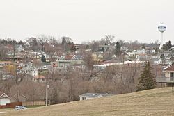
View of Oxford from 295th St
|
|

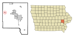
Location of Oxford, Iowa
|
|
| Country | |
| State | |
| County | Johnson |
| Area | |
| • Total | 0.93 sq mi (2.39 km2) |
| • Land | 0.93 sq mi (2.39 km2) |
| • Water | 0.00 sq mi (0.00 km2) |
| Elevation | 751 ft (229 m) |
| Population
(2020)
|
|
| • Total | 722 |
| • Density | 780.54/sq mi (301.52/km2) |
| Time zone | UTC-6 (Central (CST)) |
| • Summer (DST) | UTC-5 (CDT) |
| ZIP code |
52322
|
| Area code(s) | 319 |
| FIPS code | 19-60645 |
| GNIS feature ID | 0459975 |
Oxford is a small city in Johnson County, Iowa, United States. It is part of the larger Iowa City, Iowa area. In 2020, about 722 people lived there.
Contents
History of Oxford
Oxford was officially planned and laid out in 1868. The city gets its name from Oxford Township. This township was named after a place called Oxford, New York.
Geography of Oxford
Oxford is located at 41.722645 degrees North and 91.789841 degrees West.
The city covers a total area of about 0.91 square miles (2.39 square kilometers). All of this area is land.
People of Oxford
| Historical populations | ||
|---|---|---|
| Year | Pop. | ±% |
| 1880 | 560 | — |
| 1890 | 515 | −8.0% |
| 1900 | 664 | +28.9% |
| 1910 | 614 | −7.5% |
| 1920 | 580 | −5.5% |
| 1930 | 521 | −10.2% |
| 1940 | 542 | +4.0% |
| 1950 | 543 | +0.2% |
| 1960 | 633 | +16.6% |
| 1970 | 666 | +5.2% |
| 1980 | 676 | +1.5% |
| 1990 | 663 | −1.9% |
| 2000 | 705 | +6.3% |
| 2010 | 807 | +14.5% |
| 2020 | 722 | −10.5% |
| Source: and Iowa Data Center Source: |
||
Population in 2020
In 2020, Oxford had 722 residents. There were 318 households living in the city. The city had about 780 people per square mile.
Most residents were White (92.4%). Other groups included:
- Black or African American (0.3%)
- Native American (0.4%)
- Asian (0.3%)
- A small number of people were from other races or mixed races.
- About 3.5% of the population was Hispanic or Latino.
The average age in Oxford was 40.5 years old.
- About 25.3% of residents were under 20 years old.
- About 17.5% were 65 years or older.
- The city had slightly more females (53.5%) than males (46.5%).
Population in 2010
In 2010, Oxford had 807 people. There were 336 households. The city had about 886 people per square mile.
Most residents were White (92.9%). Other groups included:
- African American (3.3%)
- Asian (1.5%)
- A small number of people were from other races or mixed races.
- About 2.4% of the population was Hispanic or Latino.
The average age in Oxford was 35.5 years old.
- About 28.4% of residents were under 18 years old.
- About 11.5% were 65 years or older.
- The city had slightly more females (51.8%) than males (48.2%).
Education in Oxford
The Clear Creek–Amana Community School District runs the public schools in Oxford. Clear Creek Elementary School is located right in Oxford. Older students attend Clear Creek–Amana Middle School and Clear Creek–Amana High School in Tiffin, a nearby town.
The Oxford Project
The Oxford Project is a special book. It tells the stories of 100 people who live in Oxford. The book also includes their photographs, taken 20 years apart.
A photographer named Peter Feldstein, who lived in Oxford, took pictures of almost all his neighbors in 1984. Later, in 2005 and 2006, he worked with a writer named Stephen G. Bloom. They went back to take new photos and talk to as many of the original residents as they could.
See also
 In Spanish: Oxford (Iowa) para niños
 | Frances Mary Albrier |
 | Whitney Young |
 | Muhammad Ali |


