Tiffin, Iowa facts for kids
Quick facts for kids
Tiffin, Iowa
|
||
|---|---|---|
|
||
| Motto(s):
Crossroads of the Heartland
|
||

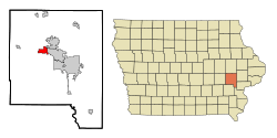
Location of Tiffin, Iowa
|
||
| Country | ||
| State | ||
| County | Johnson | |
| Government | ||
| • Type | Mayor-council government | |
| Area | ||
| • Total | 4.16 sq mi (10.78 km2) | |
| • Land | 4.16 sq mi (10.76 km2) | |
| • Water | 0.01 sq mi (0.02 km2) | |
| Elevation | 705 ft (215 m) | |
| Population
(2020)
|
||
| • Total | 4,512 | |
| • Density | 1,085.70/sq mi (419.19/km2) | |
| Time zone | UTC-6 (Central (CST)) | |
| • Summer (DST) | UTC-5 (CDT) | |
| ZIP code |
52340
|
|
| Area code(s) | 319 | |
| FIPS code | 19-78060 | |
| GNIS feature ID | 0462241 | |
| Website | http://www.tiffin-iowa.org/ | |
Tiffin is a city in Johnson County, Iowa, United States. It is part of the larger Iowa City, Iowa area. In 2020, about 4,512 people lived there.
Just west of Tiffin, you'll find F. W. Kent County Park. This park is a great spot for outdoor fun in Johnson County. It has a lake, places to camp, and you might even see whitetail deer and wild turkeys. In winter, you can enjoy cross-country ski trails through beautiful oak and hickory forests.
Contents
History of Tiffin
Tiffin was officially planned out in 1867. Its name comes from Tiffin, Ohio. Rolla Johnson, who owned the land where Tiffin, Iowa, was built, used to live in Tiffin, Ohio.
Geography and Location
Tiffin is located at 41°42′23″N 91°39′41″W / 41.70639°N 91.66139°W. This means it's in the central part of the United States.
The city covers a total area of about 4.14 square miles (10.72 square kilometers). Most of this area is land, with only a small part being water.
Population Changes in Tiffin
| Historical population | |||
|---|---|---|---|
| Census | Pop. | %± | |
| 1880 | 47 | — | |
| 1910 | 176 | — | |
| 1920 | 178 | 1.1% | |
| 1930 | 206 | 15.7% | |
| 1940 | 240 | 16.5% | |
| 1950 | 256 | 6.7% | |
| 1960 | 311 | 21.5% | |
| 1970 | 299 | −3.9% | |
| 1980 | 413 | 38.1% | |
| 1990 | 460 | 11.4% | |
| 2000 | 975 | 112.0% | |
| 2010 | 1,947 | 99.7% | |
| 2020 | 4,512 | 131.7% | |
| U.S. Decennial Census | |||
Tiffin's Population in 2020
In 2020, the census showed that 4,512 people lived in Tiffin. There were 1,749 households, which are groups of people living together.
The city had about 1,085.7 people per square mile (419.2 people per square kilometer). Most residents, about 82.4%, were White. Other groups included Black or African American (5.0%), Asian (2.5%), and Native American (0.3%). About 5.5% of the population was Hispanic or Latino.
The average age in Tiffin was 31.8 years old. Many residents, 29.7%, were under 20 years old. About 36.5% were between 25 and 44 years old.
Tiffin's Population in 2010
In 2010, the census counted 1,947 people living in Tiffin. There were 800 households.
The population density was about 471.4 people per square mile (182.0 people per square kilometer). Most people, 92.0%, were White. About 3.6% of the population was Hispanic or Latino.
The average age was 31.2 years. About 27.4% of residents were under 18 years old.
Education in Tiffin
Tiffin is part of the Clear Creek–Amana Community School District. The city is home to several schools for students of different ages:
- Tiffin Elementary School
- Clear Creek–Amana Middle School
- Clear Creek–Amana High School
See also
 In Spanish: Tiffin (Iowa) para niños
 | Percy Lavon Julian |
 | Katherine Johnson |
 | George Washington Carver |
 | Annie Easley |

