Packerton Moraine facts for kids
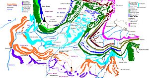
The Packerton Moraine is a large ridge of hills and rocks in north-central Indiana. It was formed by ancient glaciers. Scientists believe it sits between two huge ice sheets, called "lobes," during the last Ice Age. These lobes were the Saginaw lobe and the Erie lobe.
A moraine is like a giant pile of dirt, rocks, and sand left behind by a melting glacier. The Packerton Moraine is named after the village of Packerton in Kosciusko County.
Scientists can tell which part of the moraine was made by which ice lobe. They look at the direction of long, winding ridges called eskers. Eskers are formed by rivers flowing under the ice. For example, eskers north of Disko point one way, showing they were made by the Saginaw lobe. South of Disko, they point another way, showing they were made by the Erie lobe.
The moraine also has many kames. Kames are cone-shaped hills made of sand and gravel. These kames and eskers are mixed with lots of sand and gravel. The soil, called till, is sandier in areas formed by the Saginaw lobe. This means that part of the Saginaw lobe passed over sandy ground.
What is the Packerton Moraine Like?
The Packerton Moraine starts near Delphi in Carroll County. Here, it is about 2 to 3 kilometers (1.2 to 1.8 miles) wide. It follows the north side of the Wabash River up to Logansport. Then, it continues along the north side of the Eel River.
In Miami and Wabash Counties, the moraine gets wider. It is also further from the Eel River there. A flat area of sand and gravel, called an outwash plain, separates them. This outwash plain is about 1 to 3 kilometers (0.6 to 1.8 miles) wide.
The moraine has a bumpy, hilly surface. You can see many kames, eskers, and small lakes. The highest points are over 253 meters (830 feet) tall. Some areas have big changes in height, more than 30 meters (100 feet). Only along the Wabash River valley is the land even more uneven.
The moraine is made of a mix of till and water-laid sands and gravels. They are found together in complex ways. Some short eskers are also found in the northern part of the county. The largest esker is about 12 meters (40 feet) high. It forms a broken ridge for about 3.2 kilometers (2 miles).
How Did the Packerton Moraine Form?
The Packerton Moraine formed during a time called the Tazewell subage. This was a part of the last major Ice Age, known as the Wisconsin Glacial epoch. During this time, the Wabash, Eel, and Mississinewa Rivers were like giant drains. They carried away meltwater and sediment from the Saginaw and Erie ice lobes. These rivers are called "sluiceways."
The sand and gravel deposited by the melting glaciers is called outwash. Outwash was laid down along these major river valleys. It's hard to tell the difference between the outwash from the Tazewell subage and outwash from a later time called the Cary substage.
However, older Tazewell outwash can be seen along smaller streams. These include Mill, Big and Little Pipe, and Deer Creeks. There are also three streams that flow south into the Eel River. These smaller streams were not used as sluiceways during the later Cary substage.
The Packerton Moraine, where Shoe Lake is located, belongs to the moraines formed by the Saginaw lobe. This part of the moraine formed during the late Wisconsin Substage. It starts in northern Carroll County. From there, it stretches northeast through Cass, Miami, Fulton, Kosciusko, and Whitley Counties. It ends in the middle of Noble County. Here, it connects with the moraine system of the Erie Lobe. Shoe Lake is about 3.2 kilometers (2 miles) southeast of Oswego, Indiana. It is also about 1.6 kilometers (1 mile) south of the eastern end of Tippecanoe Lake.
 | DeHart Hubbard |
 | Wilma Rudolph |
 | Jesse Owens |
 | Jackie Joyner-Kersee |
 | Major Taylor |


