Pactola Dam facts for kids
Quick facts for kids Pactola Dam |
|
|---|---|
 |
|
|
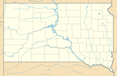
Location of Pactola Dam in USA South Dakota
|
|
| Country | United States |
| Location | Pennington County, South Dakota |
| Coordinates | 44°04′16″N 103°29′10″W / 44.07111°N 103.48611°W |
| Opening date | 1956 |
| Dam and spillways | |
| Type of dam | Earthfill |
| Impounds | Rapid Creek |
| Height (foundation) | 245 ft (75 m) |
| Length | 2,236 ft (682 m) |
| Reservoir | |
| Creates | Pactola Lake |
| Total capacity | 99,029 acre⋅ft (122,150,000 m3) |
| Surface area | 1,232 acres (499 ha) |
| Normal elevation | 4,580 ft (1,400 m) |
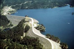
Pactola Dam is a large embankment dam built on Rapid Creek in Pennington County, South Dakota. It is located about 10 miles (16 km) west of Rapid City. The U.S. Bureau of Reclamation finished building the dam in 1956. Its main jobs are to help control floods, provide water for people, and create a place for recreation.
Pactola Dam is part of a bigger plan called the Rapid Valley Unit of the Pick-Sloan Missouri Basin Program. U.S. Route 385 even runs right over the top of the dam! The dam forms Pactola Lake, which covers over 1,200 acres (490 ha). It is the biggest and deepest body of water in the Black Hills.
Contents
History of Pactola Dam
The Town Under the Lake
The dam is named after a town called Pactola. This town is now covered by the waters of the lake. The town's name came from an ancient river in Lydia (which is now part of Turkey). That river, called Pactolus, was famous for the gold found in its riverbed.
Miners gave the name "Pactola" to this valley after the Black Hills Gold Rush of 1874–1877. The gold rush led to conflicts over land. Eventually, many miners left Pactola to find more gold elsewhere. However, a few people continued to live in the town until the 1950s. That's when the Bureau of Reclamation started buying and clearing the land to build the dam and reservoir.
Why the Dam Was Built
Pactola Dam was built as part of a larger project to help the growing town of Rapid City. The town needed more water for farming and for people to use in their homes. The existing water supply, mostly from wells, was running out.
The Bureau of Reclamation first looked into building a dam on Rapid Creek in 1937. They chose the final spot for the dam in 1939. However, there was a debate about whether Pactola Dam or Deerfield Dam should be built first. Because of this, some of the money for the Rapid Valley Unit was used for a different project. The Bureau of Reclamation decided to build Deerfield Dam first, which was finished in 1948.
Building the Dam
Pactola Dam was approved in 1944, but construction was delayed partly because of World War II. By 1948, the Rapid Valley Water Conservancy District asked the Bureau of Reclamation to build Pactola. Deerfield Dam alone could not provide enough water for the area. In 1949, Rapid City also asked for water from the future Pactola Reservoir. Some of this water would be used at Ellsworth Air Force Base.
Construction on Pactola Dam began on November 25, 1952. Up to 200 people worked on the dam at one time. No one died during the four years of building, but there were many injuries because the area was dangerous. Before the reservoir was filled, all the buildings in Pactola were moved or torn down. The dam was completed on August 15, 1956. The first water from Pactola Reservoir was delivered on May 1, 1958.
Protecting Against Floods
During the Black Hills Flood of 1972, Pactola Dam held back most of the floodwater coming from upstream. However, the heaviest rains happened below the dam. This caused a terrible flood in Rapid City. Even so, the dam helped prevent even worse damage. In 1987, the dam was made 15 feet (4.6 m) taller, and its spillway was made bigger. This was done to offer even better protection against future floods.
Dam Features and Size
Pactola Dam is made up of a main earth-filled dam and two smaller walls, called auxiliary dikes, on its northern side. The main dam stands 245 feet (75 m) high from its base. It is 199.5 feet (60.8 m) tall above the riverbed. The dam and its dikes together are 2,236 feet (682 m) long. They contain a huge amount of material, about 4,532,000 cubic yards (3,465,000 m³).
The very top of the dam is 4,655 feet (1,419 m) above sea level. The spillway, which is a concrete structure that lets extra water flow out, is located between the main dam and the dikes. It can release a lot of water, up to 245,000 cubic feet per second (6,900 m³/s). The dam also has special outlet works that can release 1,150 cubic feet per second (33 m³/s) of water.
Pactola Lake Details
Pactola Lake is about 5 miles (8.0 km) long and has 16 miles (26 km) of shoreline. At normal water levels, it covers 1,232 acres (499 ha). The reservoir can hold 99,029 acre-feet (122,150,000 m³) of water. About 54,955 acre-feet (67,780,000 m³) of this water can be used. The normal water level of the lake is 4,580 feet (1,400 m) above sea level. The lake collects water from a drainage area of 319 square miles (826 km²). The small town of Silver City is located at the western end of the lake.
Fun at Pactola Lake
The U.S. Forest Service runs the Pactola Visitor Center. It is located at the south end of Pactola Dam. At the center, you can learn about the area, get travel information, and enjoy a beautiful view of the lake.
The Pactola Pines Marina is located at Custer Gulch on the south shore of the lake. It opened in 2000. This marina can hold 200 boats. You can also rent fishing boats, canoes, and paddleboards there.
Pactola Lake is well-known for its large lake trout. You can also find brown trout in Rapid Creek both above and below the dam. The creek right below the dam is considered an "exceptional" place for fly fishing.
 | Tommie Smith |
 | Simone Manuel |
 | Shani Davis |
 | Simone Biles |
 | Alice Coachman |


