
Paihia facts for kids
Quick facts for kids
Paihia
|
|
|---|---|

Williams Road
|
|
| Country | New Zealand |
| Region | Northland Region |
| District | Far North District |
| Ward | Bay of Islands-Whangaroa Ward |
| Community | Bay of Islands-Whangaroa |
| Subdivision | Paihia |
| Electorates |
|
| Area | |
| • Total | 2.24 km2 (0.86 sq mi) |
| Population
(June 2023)
|
|
| • Total | 1,720 |
| • Density | 768/km2 (1,989/sq mi) |
| Postcode(s) |
0200
|

Paihia is a popular tourist town in the Bay of Islands in New Zealand's North Island. It's located in the Northland Region, about 60 kilometres north of Whangārei. Paihia is close to other important historical towns like Russell and Kerikeri.
The town was originally named Marsden's Vale by missionary Henry Williams. However, the name Paihia eventually became the official name. To the north of Paihia is Waitangi, a very important historical place. To the west is Haruru Falls, and to the south are the port town of Opua and the small settlement of Te Haumi.
Contents
What is the History of Paihia?
How Did Paihia Get Its Name?
The exact story behind the name "Paihia" isn't fully clear. A popular story says that when Reverend Henry Williams first arrived, he told his Māori guide, "Pai here!" This meant "Good here!" because he didn't know much Māori yet. This story is probably not true, but it's a fun legend!
When Did Europeans Settle in Paihia?
_(cropped).jpg)

In 1823, Henry Williams and his wife Marianne made Paihia their home. They built the first church there in the same year. Later, in 1826, William Williams and his wife Jane also joined the mission in Paihia.
A special ship called the Herald was built by missionaries. It was a 55-ton schooner, launched right off the beach at Paihia on January 24, 1826.
In 1832, the first mention of cricket being played in New Zealand was recorded by Henry Williams. The famous scientist Charles Darwin even saw a game of cricket here in December 1835. This was when his ship, the Beagle, spent 10 days in the Bay of Islands.
In 1835, William Colenso set up New Zealand's very first printing press in Paihia. This was a big step for sharing information and books!
By 1850, the mission closed, and Paihia became a much smaller settlement by 1890.
What Happened in Paihia in the 20th Century?
St. Paul's Anglican Church, finished in 1925, is the fifth church built on this important site. It was made using stone from a place called Pukaru and wood from near Waikare. The beautiful stained glass windows above the pulpit were added in 1998. They are called Te Ara O Te Manawa, which means "Pathway of the Heart".
In 1925, a new road was built to Puketona, connecting Paihia to the main road. This made it easier for people to visit, and tourism grew a lot in the 1930s.
What is the Population of Paihia?
Paihia covers about 2.24 square kilometres. It stretches from the Waitangi River in the north to the Haumi River in the south.

As of 2023, Paihia had a population of 1,623 people. This was an increase of 111 people since the 2018 census. The average age of people living in Paihia was 51 years old. About 11.6% of the population was under 15 years old.
Most people in Paihia are of European (Pākehā) background (66.7%), and a significant number are Māori (35.1%). Other groups include Pasifika, Asian, and Middle Eastern, Latin American and African New Zealanders. English is spoken by most people (97.4%), and 11.5% speak the Māori language.
What is a Marae?
Te Tii Waitangi marae and Te Tiriti o Waitangi meeting house are located in Te Tī Bay, at the northern end of Paihia. A marae is a special meeting place for Māori people. This marae is connected to the Ngāpuhi hapū (sub-tribes) called Ngāti Kawa and Ngāti Rāhiri. In 2020, the government helped fund new roofs for the buildings at this marae.
What Schools are in Paihia?
Paihia School is a school for students in years 1 to 8 (ages 5-13). It is a coeducational school, meaning both boys and girls attend. As of 2023, it had about 130 students.
What is the Climate Like in Paihia?
Paihia has an oceanic climate, which means it has mild temperatures all year round. It can be quite rainy in winter. The climate is also influenced by subtropical weather, making it one of the mildest places in New Zealand.
| Climate data for Paihia (Waitangi Forest) (1991–2020) | |||||||||||||
|---|---|---|---|---|---|---|---|---|---|---|---|---|---|
| Month | Jan | Feb | Mar | Apr | May | Jun | Jul | Aug | Sep | Oct | Nov | Dec | Year |
| Mean daily maximum °C (°F) | 24.2 (75.6) |
24.3 (75.7) |
23.1 (73.6) |
20.7 (69.3) |
18.8 (65.8) |
16.6 (61.9) |
15.9 (60.6) |
16.1 (61.0) |
17.7 (63.9) |
19.1 (66.4) |
20.4 (68.7) |
22.8 (73.0) |
20.0 (68.0) |
| Daily mean °C (°F) | 19.4 (66.9) |
20.0 (68.0) |
18.7 (65.7) |
16.5 (61.7) |
14.8 (58.6) |
12.3 (54.1) |
11.6 (52.9) |
12.0 (53.6) |
13.4 (56.1) |
14.5 (58.1) |
15.9 (60.6) |
18.2 (64.8) |
15.6 (60.1) |
| Mean daily minimum °C (°F) | 14.7 (58.5) |
15.8 (60.4) |
14.3 (57.7) |
12.3 (54.1) |
10.8 (51.4) |
7.9 (46.2) |
7.2 (45.0) |
7.8 (46.0) |
9.0 (48.2) |
10.0 (50.0) |
11.4 (52.5) |
13.6 (56.5) |
11.2 (52.2) |
| Average rainfall mm (inches) | 84.9 (3.34) |
125.5 (4.94) |
169.4 (6.67) |
120.7 (4.75) |
95.3 (3.75) |
140.3 (5.52) |
134.5 (5.30) |
119.1 (4.69) |
133.5 (5.26) |
115.4 (4.54) |
97.6 (3.84) |
88.0 (3.46) |
1,424.2 (56.06) |
| Mean monthly sunshine hours | 229.4 | 176.8 | 163.5 | 148.4 | 145.6 | 112.9 | 142.5 | 142.2 | 161.5 | 206.8 | 174.6 | 199.9 | 2,004.1 |
| Source: NIWA | |||||||||||||
Images for kids
-
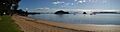
Taiputuputu Pahi Beach looking north toward Paihia wharf and Motumarie
See also
 In Spanish: Paihia para niños
