Palermo, New York facts for kids
Quick facts for kids
Palermo, New York
|
|
|---|---|

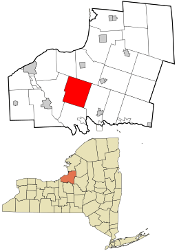
Location in Oswego County and the state of New York.
|
|
| Country | United States |
| State | New York |
| County | Oswego |
| Area | |
| • Total | 40.74 sq mi (105.52 km2) |
| • Land | 40.46 sq mi (104.80 km2) |
| • Water | 0.28 sq mi (0.72 km2) |
| Elevation | 436 ft (133 m) |
| Population
(2010)
|
|
| • Total | 3,664 |
| • Estimate
(2016)
|
3,586 |
| • Density | 88.62/sq mi (34.22/km2) |
| Time zone | UTC-5 (Eastern (EST)) |
| • Summer (DST) | UTC-4 (EDT) |
| ZIP code |
13069
|
| Area code(s) | 315 |
| FIPS code | 36-56154 |
| GNIS feature ID | 0979338 |
Palermo is a small town in Oswego County, located in the state of New York in the United States. In 2010, about 3,664 people lived there. The town gets its name from the city of Palermo in Sicily, Italy.
The Town of Palermo is right in the middle of Oswego County, just east of the city of Fulton.
Contents
History of Palermo
The first people to settle permanently in the area arrived around 1803. The Town of Palermo was officially created in 1832. It was formed from a part of another town called Volney.
Geography of Palermo
According to the United States Census Bureau, the town of Palermo covers a total area of about 40.8 square miles (which is about 105.5 square kilometers). Most of this area, about 40.6 square miles (105.2 square kilometers), is land. Only a small part, about 0.2 square miles (0.5 square kilometers), is water.
Population in Palermo
| Historical population | |||
|---|---|---|---|
| Census | Pop. | %± | |
| 1840 | 1,928 | — | |
| 1850 | 2,053 | 6.5% | |
| 1860 | 2,088 | 1.7% | |
| 1870 | 2,052 | −1.7% | |
| 1880 | 1,936 | −5.7% | |
| 1890 | 1,607 | −17.0% | |
| 1900 | 1,407 | −12.4% | |
| 1910 | 1,255 | −10.8% | |
| 1920 | 1,046 | −16.7% | |
| 1930 | 1,012 | −3.3% | |
| 1940 | 1,148 | 13.4% | |
| 1950 | 1,397 | 21.7% | |
| 1960 | 1,663 | 19.0% | |
| 1970 | 2,321 | 39.6% | |
| 1980 | 3,253 | 40.2% | |
| 1990 | 3,582 | 10.1% | |
| 2000 | 3,686 | 2.9% | |
| 2010 | 3,664 | −0.6% | |
| 2016 (est.) | 3,586 | −2.1% | |
| U.S. Decennial Census | |||
In 2000, a census showed that 3,686 people lived in Palermo. There were 1,306 households, and 1,000 of these were families. The population density was about 90.8 people per square mile (or 35.1 people per square kilometer).
The average household in Palermo had about 2.82 people. The average family size was about 3.14 people.
The town's population was spread out by age. About 29.3% of the people were under 18 years old. About 8.2% were 65 years old or older. The average age of people in Palermo was 35 years.
Communities and Locations in Palermo
Palermo has several smaller communities and specific locations within its borders:
- Catfish – A small village in the northeastern part of the town.
- Clifford – A village located north of the main Palermo village. It used to be known as "Dentons Corners."
- Cribbs Corners – A village northeast of Palermo village, found along Route 3.
- East Palermo – A village situated to the east of the main Palermo village.
- Farley Corners – A spot located right at the western edge of the town.
- Loomis Corner – A village south of Palermo village, located on Route 264.
- Mungers Corners – A village found northeast of Palermo village.
- Palermo – This is the main village of Palermo, located on Route 3. It's also called "Palermo Center" and was once known as "Jennings Corners."
- Peat Corners – A village south of East Palermo.
- Russ Mills – A village north of East Palermo.
- Russ Pond – A small lake located north of Russ Mills.
- Sayles Corners – A location in the northwestern part of the town.
- Sutton Corner – A village near the southern town line, where Routes 49 and 264 meet.
- Upson Corner – A village north of East Palermo.
- Vermillion – A village at the northern border of the town, located on Catfish Creek.
See also
 In Spanish: Palermo (Nueva York) para niños
 | Audre Lorde |
 | John Berry Meachum |
 | Ferdinand Lee Barnett |

