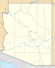
Palomas Mountains facts for kids
Quick facts for kids Palomas Mountains |
|
|---|---|
| Highest point | |
| Peak | (33°00'52"N, 113°38'06"W) |
| Elevation | 575 m (1,886 ft) |
| Geography | |
| Country | United States |
| State | Arizona |
| Range coordinates | 33°00′50″N 113°37′59″W / 33.01389°N 113.63306°W |
The Palomas Mountains (called Hakiñur by the Yavapai people) are a mountain range in the Sonoran Desert of southwest Arizona. These mountains are a natural landmark in the desert landscape.
Exploring the Palomas Mountains
Where Are the Palomas Mountains?
The Palomas Mountains are located about 70 miles northeast of Yuma, Arizona. They are also about 15 miles north of the town of Dateland. You can find them in the eastern part of Yuma County.
The mountains are surrounded by other interesting places. To the north, across a narrow valley, are the Tank Mountains. These mountains connect to the Kofa Mountains further west. To the west, you'll find Neversweat Ridge, which has a special type of rock called Orocopia Schist. To the east and northeast is a flat area known as the Palomas Plain. The Gila River flows to the south of the mountains.
Getting Around and Safety
It is fairly easy to get to the Palomas Mountains. Many of the dirt roads are in good condition. You can even drive on some parts with a regular two-wheel drive car. However, some roads cross sandy areas. For these parts, you will need a four-wheel drive vehicle.
It is important to know that the western part of the mountain range is inside the Yuma Proving Ground. This is a military testing area. If you want to visit this part, you must get special permission first.
 | Emma Amos |
 | Edward Mitchell Bannister |
 | Larry D. Alexander |
 | Ernie Barnes |


