Panoche Valley facts for kids
Quick facts for kids Panoche Valley |
|
|---|---|
| Floor elevation | 1,253 ft (382 m) |
| Geography | |
| Topo map | Panoche, Mercey Hot Springs, Llanada |
| Rivers | Panoche Creek, Las Aguilas Creek, Griswold Creek |
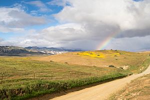
Panoche Valley is a beautiful grassland valley in San Benito County, California. It sits between two mountain ranges: the Diablo Range and the San Joaquin Valley. The valley is surrounded by hills and mountains. To the north are the Panoche Hills, to the east are the Tumey Hills, and to the south are the Griswold Hills and Cerro Bonito. The Las Aguilas Mountains are to the west.
Many nature lovers and scientists know Panoche Valley as a special place. It is home to many rare birds and mammals. It also offers a peek into what California looked like a long time ago.
History of Panoche Valley
The valley was first called Valle de Panoche Grande by early settlers. This name means "Big Panoche Valley." Later, people started calling it just Panoche Valley. The name Panoche comes from a Mexican Spanish word. It refers to a type of coarse sugar made in Mexico. It can also be a small version of the word for "bread."
Today, Panoche Valley is also home to the Panoche Valley Solar Farm. This farm uses the sun's energy to create electricity.
Geography and Natural Wonders
The upper part of Panoche Valley is located northwest of Walker Peak. This is where Panoche Creek flows into the Diablo Range. The exact spot is at 36°36′59″N 120°56′29″W / 36.61639°N 120.94139°W.
The small town of Panoche is also found within this valley. After winters with lots of rain, the valley becomes a spectacular sight. It fills with amazing displays of colorful wildflowers in the spring.
 | Calvin Brent |
 | Walter T. Bailey |
 | Martha Cassell Thompson |
 | Alberta Jeannette Cassell |


