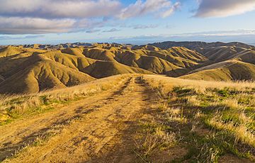
Panoche Hills facts for kids
Quick facts for kids Panoche Hills |
|
|---|---|
 |
|
| Highest point | |
| Elevation | 675 m (2,215 ft) |
| Geography | |
| Country | United States |
| State | California |
| District | Fresno County |
| Range coordinates | 36°38′40.828″N 120°43′54.641″W / 36.64467444°N 120.73184472°W |
| Parent range | Diablo Range |
| Topo map | USGS Chounet Ranch |
The Panoche Hills are a group of low mountains in western Fresno County, California. They are part of the Southern Inner California Coast Ranges System.
These hills are located east of the Diablo Range. They sit on the western side of the San Joaquin Valley, which is a large, flat area. The Panoche Hills also form the eastern edge of the Panoche Valley.
Contents
Fun Places to Explore
The Panoche Hills are home to some special areas where you can explore nature!
Panoche Hills Recreation Area
One of these places is the Panoche Hills Recreation Area. It's managed by the Bureau of Land Management (BLM). The BLM is a government agency that takes care of public lands. This recreation area is a great spot for outdoor activities. You can find the entrance to this area across Little Panoche Road, near the Mercey Hot Springs resort.
Panoche Hills Ecological Reserve
Another special place is the Panoche Hills Ecological Reserve. The California Department of Fish and Game manages this area. An ecological reserve is a protected natural area. It helps to keep plants and animals safe in their natural homes.
Natural History Discoveries
The Panoche Hills are also interesting for their natural history. Scientists have found very old fossils here. These fossils are from the Mesozoic era, which was a very long time ago. They are special because they come from "cold seeps." Cold seeps are places on the ocean floor where fluids rich in chemicals come out. Finding these fossils helps us learn about ancient life and environments.
 | Janet Taylor Pickett |
 | Synthia Saint James |
 | Howardena Pindell |
 | Faith Ringgold |


