Paoli, Colorado facts for kids
Quick facts for kids
Paoli, Colorado
|
|
|---|---|

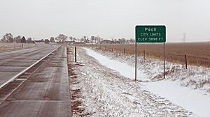
Entering Paoli from the west on U.S. Route 6 (2013)
|
|

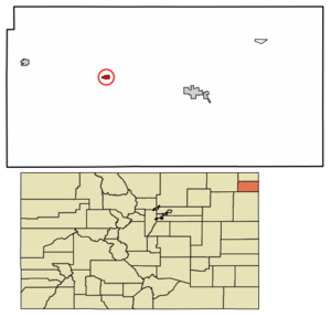
Location within Phillips County and Colorado
|
|
| Country | United States |
| State | Colorado |
| County | Phillips |
| Incorporated | August 6, 1930 |
| Named for | Pasquale Paoli |
| Area | |
| • Total | 0.30 sq mi (0.77 km2) |
| • Land | 0.30 sq mi (0.77 km2) |
| • Water | 0.00 sq mi (0.00 km2) |
| Elevation | 3,895 ft (1,187 m) |
| Population
(2020)
|
|
| • Total | 51 |
| • Density | 170/sq mi (66.2/km2) |
| Time zone | UTC−7 (MST) |
| • Summer (DST) | UTC−6 (MDT) |
| ZIP Code |
80746 (PO Box)
|
| Area code | 970 |
| FIPS code | 08-57245 |
| GNIS ID | 182821 |
Paoli is a small town located in Phillips County, Colorado, in the United States. It's known as a "statutory town," which means it follows specific rules set by the state of Colorado for how towns are governed. In 2020, about 51 people lived there.
Contents
About Paoli, Colorado
Paoli has had a post office since 1888, helping people send and receive mail for a very long time. The town got its name from another place called Paoli, Pennsylvania.
Where is Paoli Located?
Paoli is found in northeastern Colorado. You can find it at these coordinates: 40 degrees, 36 minutes, 44 seconds North and 102 degrees, 28 minutes, 22 seconds West. This helps pinpoint its exact spot on a map.
The town is quite small in size. It covers an area of about 0.3 square miles (which is about 0.77 square kilometers). All of this area is land, with no large bodies of water like lakes or rivers inside the town limits.
Paoli's Population Over Time
The word "demographics" helps us understand the population of a place, like how many people live there and how that number changes over the years. Paoli's population has varied quite a bit since 1940:
| Historical population | |||
|---|---|---|---|
| Census | Pop. | %± | |
| 1940 | 85 | — | |
| 1950 | 91 | 7.1% | |
| 1960 | 81 | −11.0% | |
| 1970 | 52 | −35.8% | |
| 1980 | 81 | 55.8% | |
| 1990 | 29 | −64.2% | |
| 2000 | 42 | 44.8% | |
| 2010 | 34 | −19.0% | |
| 2020 | 51 | 50.0% | |
| U.S. Decennial Census | |||
As you can see, the population was highest in 1950 with 91 people and lowest in 1990 with 29 people. In 2020, the population was 51.
Images for kids
See also
 In Spanish: Paoli (Colorado) para niños
 | Bessie Coleman |
 | Spann Watson |
 | Jill E. Brown |
 | Sherman W. White |


