
Parapet Peak facts for kids
Quick facts for kids Parapet Peak |
|
|---|---|

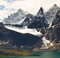
Parapet Peak is the dark peak between Bennington Peak (left), and Paragon Peak (right)
|
|
| Highest point | |
| Elevation | 3,031 m (9,944 ft) |
| Prominence | 177 m (581 ft) |
| Geography | |

Parapet Peak
Location in Alberta

Parapet Peak
Location in Canada
|
|
| Location | Alberta British Columbia |
| Parent range | Park Ranges |
| Topo map | NTS 83D/09 |
Parapet Peak is a cool mountain located right on the border between the Canadian provinces of Alberta and British Columbia. It's part of the amazing Canadian Rockies mountain range. This peak got its name in 1921 from a person named Cyril G. Wates. A "parapet" is a low protective wall, and the mountain's shape might have reminded him of one!
Mountain Weather and Water
Parapet Peak experiences a subarctic climate. This means it has very cold, snowy winters and mild, short summers. Imagine temperatures dropping super low, sometimes even below -20 °C (that's -4 °F)! With the wind chill, it can feel even colder, like -30 °C (-22 °F) or less.
Best Time to Visit
If you ever wanted to climb Parapet Peak, the best time to go is usually in July and August. The weather is much milder then. However, these warmer months are also when mosquitoes are out in full force! So, if you visit, be sure to bring good insect repellent.
Mountain Water Flow
The water from melting snow and rain on Parapet Peak flows in two different directions. On the east side, the water runs into streams that eventually join the mighty Athabasca River. This river flows all the way to the Arctic Ocean! On the west side, the water flows into the beginnings of the Fraser River, which eventually reaches the Pacific Ocean. It's pretty neat how one mountain can send its water to two different oceans!
Images for kids
-
Parapet Peak is the dark peak between Bennington Peak (left), and Paragon Peak (right)
