Parker, Pennsylvania facts for kids
Quick facts for kids
Parker, Pennsylvania
|
|
|---|---|

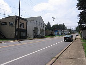
The Old Lawrenceburg section of Parker
|
|
| Nickname(s):
Smallest City in the U.S.A.
|
|

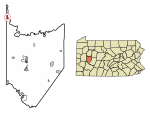
Location of Parker in Armstrong County, Pennsylvania.
|
|

Location in the state of Pennsylvania
|
|
| Country | United States |
| State | Pennsylvania |
| County | Armstrong County |
| Settled | 1797 |
| Incorporated | 1873 |
| Area | |
| • Total | 0.96 sq mi (2.48 km2) |
| • Land | 0.96 sq mi (2.48 km2) |
| • Water | 0.00 sq mi (0.00 km2) |
| Population
(2020)
|
|
| • Total | 695 |
| • Density | 726.99/sq mi (280.58/km2) |
| Time zone | UTC-5 (EST) |
| • Summer (DST) | UTC-4 (EDT) |
| ZIP code |
16049
|
| Area code(s) | 724 |
| FIPS code | 42-57976 |
Parker is a small city in Armstrong County, Pennsylvania, United States. It is located in the very northwest part of the county. In 2020, about 695 people lived there. The city is named after Judge John Parker. He was a main surveyor of Lawrenceburg and owned Parker's Landing. These two villages joined to create Parker.
Parker is sometimes called the "Smallest City in the USA." It became a city on March 1, 1873. This happened during the big oil boom in northwestern Pennsylvania. The new city was formed by combining Parker's Landing, which was on the Allegheny River, and Lawrenceburg, which was on a hill above the river. People thought Parker would become a very large city. At the peak of the oil boom, over 20,000 people lived there! However, the oil boom ended quickly. By the 1880s, Parker went back to being a small town. Its population became about 1,000 people.
Parker got national attention again in 2014. A huge ice jam formed on the Allegheny River. This caused some minor flooding. The ice jam was so big that tourists came to see it. A local bar even named a drink after the ice jam! The ice jam was serious enough that the National Weather Service issued a flood warning. This warning was in case the ice started to melt.
Contents
Getting Around Parker
Roads and Highways
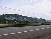
Two main roads pass through Parker. PA 268 goes right through the center of town. It then heads north towards Foxburg and Emlenton. There is also a meeting point with PA 368 at the Parker Bridge.
Waterways and Boating
The Allegheny River flows past Parker. It is not used for carrying goods anymore. However, it is still a great place for boating. The first lock on the river, called Allegheny River Lock and Dam No. 9, is south of Parker. It is just past the town of East Brady.
Where is Parker Located?
Parker is found at coordinates 41.094151 degrees north and -79.682771 degrees west. The United States Census Bureau says the city covers about 1.1 square miles (2.48 square kilometers). All of this area is land.
Neighboring Towns and Areas
Parker shares its borders with two townships on land. To the north is Hovey Township. To the south is Perry Township. Across the Allegheny River to the east, Parker is next to Perry Township in Clarion County. You can get there directly using the Parker Bridge.
People of Parker
| Historical population | |||
|---|---|---|---|
| Census | Pop. | %± | |
| 1880 | 1,835 | — | |
| 1890 | 1,317 | −28.2% | |
| 1900 | 1,070 | −18.8% | |
| 1910 | 1,244 | 16.3% | |
| 1920 | 1,188 | −4.5% | |
| 1930 | 902 | −24.1% | |
| 1940 | 976 | 8.2% | |
| 1950 | 979 | 0.3% | |
| 1960 | 945 | −3.5% | |
| 1970 | 843 | −10.8% | |
| 1980 | 808 | −4.2% | |
| 1990 | 853 | 5.6% | |
| 2000 | 799 | −6.3% | |
| 2010 | 840 | 5.1% | |
| 2020 | 695 | −17.3% | |
| Sources: | |||
In 2000, there were 799 people living in Parker. There were 309 households and 221 families. About 32.4% of households had children under 18. Most households (58.9%) were married couples. About 25.2% of households were single people. Around 15.9% of people living alone were 65 or older.
The average household had about 2.59 people. The average family had about 3.09 people. The population was spread out by age. About 26.0% were under 18. About 16.6% were 65 or older. The average age was 36 years old. For every 100 females, there were about 95.4 males.
The average income for a household in Parker was $29,844. For families, it was $35,250. About 10.2% of families and 9.8% of all people lived below the poverty line. This included 9.7% of those under 18.
History of Parker
A post office was first set up in Parker in 1871. It was called Parker's Landing. In 1894, its name changed to Parkers Landing. Then in 1950, it became simply Parker. The post office is still open today. Parker also appears on an old map from 1876. This map is called the Atlas of Armstrong County, Pennsylvania.
Cemeteries in Parker
- Grand Army of the Republic Cemetery
- Parker Presbyterian Cemetery
See also
 In Spanish: Parker (Pensilvania) para niños
 | Tommie Smith |
 | Simone Manuel |
 | Shani Davis |
 | Simone Biles |
 | Alice Coachman |


