Parks, Louisiana facts for kids
Quick facts for kids
Parks, Louisiana
La Pointe de Repose
|
|
|---|---|
|
Village
|
|
| Village of Parks | |

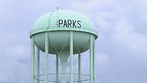
Parks water tower
|
|
| Nickname(s):
Potier
|
|

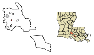
Location of Parks in St. Martin Parish, Louisiana.
|
|
| Country | |
| State | |
| Parish | St.Martin |
| Founded | 1765 |
| Renamed | 1908 |
| Founded by | Paul Melancon |
| Area | |
| • Total | 0.89 sq mi (2.30 km2) |
| • Land | 0.84 sq mi (2.19 km2) |
| • Water | 0.04 sq mi (0.11 km2) |
| Elevation | 26 ft (8 m) |
| Population
(2020)
|
|
| • Total | 640 |
| • Density | 757.40/sq mi (292.43/km2) |
| Time zone | UTC-6 (CST) |
| • Summer (DST) | UTC-5 (CDT) |
| Area code(s) | 337 |
| FIPS code | 22-59165 |
Parks is a small village located in St. Martin Parish, Louisiana, United States. It is part of the wider Lafayette metropolitan area. In 2020, about 640 people lived in Parks.
Contents
History of Parks
The name "Parks" has an interesting story. Some people think it's connected to the railroad. One popular tale says that when the first train arrived on Easter Sunday, the engineer (who didn't speak French) asked for the town's name. The locals replied, "C'est Pacques" (it's Easter in French). The engineer thought they said "Parks," and the name stuck!
Before it was called Parks, the area was known as Potier. It was also called La Pointe de Repose, which means "The Resting Point." This name might have come from cowhands who used to gather their cattle in a sharp bend of the bayou (a slow-moving stream) for a rest.
People started settling in the Parks village shortly after 1900. A man named Paul Melancon bought a large piece of land to start a cotton farm. But he soon decided to divide some of his land into town lots, and that's how the community began to grow. In 1908, the village, which was about 330 acres big, officially became a town. Parks has stayed about the same size ever since.
Geography of Parks
Parks is located in a region of southern Louisiana called Acadiana. It sits at coordinates 30°12′56″N 91°49′46″W / 30.21556°N 91.82944°W. Two main highways, Highway 31 and Highway 347, pass through the village. Both of these highways run alongside the Bayou Teche.
The city of Breaux Bridge is about 7 miles northwest of Parks. St. Martinville, which is the main town for the parish, is about 7 miles to the south. According to the United States Census Bureau, the village covers an area of about 0.8 square miles (2.1 square kilometers), and all of it is land.
Population of Parks
| Historical population | |||
|---|---|---|---|
| Census | Pop. | %± | |
| 1910 | 466 | — | |
| 1920 | 766 | 64.4% | |
| 1930 | 409 | −46.6% | |
| 1940 | 460 | 12.5% | |
| 1950 | 460 | 0.0% | |
| 1960 | 413 | −10.2% | |
| 1970 | 491 | 18.9% | |
| 1980 | 545 | 11.0% | |
| 1990 | 400 | −26.6% | |
| 2000 | 533 | 33.3% | |
| 2010 | 653 | 22.5% | |
| 2020 | 640 | −2.0% | |
| U.S. Decennial Census | |||
In 2020, the village of Parks had a population of 640 people. The 2010 census recorded 653 people living there.
In 2019, it was estimated that about 57% of the people in Parks were white, and about 42% were Black or African American. A small percentage (less than 1%) were of two or more races. The average income for a household was about $45,568 per year. About 10% of the population lived at or below the poverty line, which means they had a very low income.
Education in Parks
Public schools in St. Martin Parish are managed by the St. Martin Parish School Board. Children living in Parks attend specific schools based on their grade level.
- Parks Primary School serves students from pre-kindergarten to 4th grade.
- Parks Middle School is for students in grades 5 through 8.
- For high school, students in Parks can attend either Breaux Bridge High School or St. Martinville High School for grades 9 through 12.
Notable People from Parks
- Fred Mills is a Republican politician who serves as a member of the Louisiana State Senate. This means he helps make laws for the state of Louisiana.
See also
 In Spanish: Parks (Luisiana) para niños
 | Bessie Coleman |
 | Spann Watson |
 | Jill E. Brown |
 | Sherman W. White |


