Parkville, Missouri facts for kids
Quick facts for kids
Parkville, Missouri
|
|
|---|---|

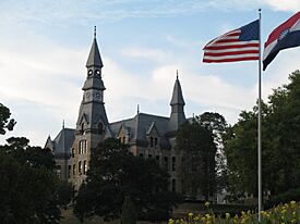
McKay Hall at Park University
|
|

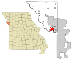
Location of Parkville, Missouri
|
|
 |
|
| Country | United States |
| State | Missouri |
| County | Platte |
| Platted | 1844 |
| Area | |
| • Total | 15.576 sq mi (40.342 km2) |
| • Land | 14.948 sq mi (38.715 km2) |
| • Water | 0.628 sq mi (1.625 km2) |
| Elevation | 748 ft (228 m) |
| Population
(2020)
|
|
| • Total | 7,117 |
| • Estimate
(2022)
|
8,541 |
| • Density | 574.3/sq mi (221.7/km2) |
| Time zone | UTC−6 (Central (CST)) |
| • Summer (DST) | UTC−5 (CDT) |
| ZIP codes |
64151-64152
|
| Area code(s) | 816 |
| FIPS code | 29-56288 |
| GNIS feature ID | 2396154 |
| Sales tax | 7.975% |
Parkville is a city in Platte County, Missouri, United States. It is part of the larger Kansas City Metropolitan Area. In 2020, about 7,177 people lived here. By 2022, the population was estimated to be 8,541.
Parkville is known for its unique antique shops and art galleries. It also has a historic downtown area. The city is home to Park University, English Landing Park, and the National Golf Club of Kansas City. Some large neighborhoods in Parkville include Riss Lake, The National, and Thousand Oaks.
Contents
History of Parkville
A post office was opened in the area in 1841. It was named Parkville after George S. Park, an early settler. The town of Parkville was officially planned out, or platted, in 1844. The original post office closed in 1962.
Several important buildings in Parkville are listed on the National Register of Historic Places. These include the Benjamin Banneker School, the Mackay Building, and the Washington Chapel C.M.E. Church. The Waddell "A" Truss Bridge is also a historic landmark.
Geography and Location
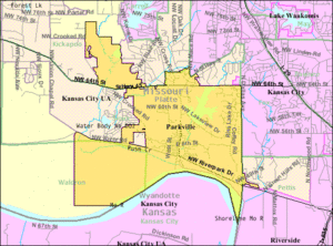
Parkville is a city with many hills. It is located next to the Missouri River and borders Kansas City, Missouri.
According to the United States Census Bureau, Parkville covers a total area of about 15.58 square miles (40.34 square kilometers). Most of this area, about 14.95 square miles (38.72 square kilometers), is land. The rest, about 0.63 square miles (1.63 square kilometers), is water.
Population and People
| Historical population | |||
|---|---|---|---|
| Census | Pop. | %± | |
| 1850 | 309 | — | |
| 1880 | 482 | — | |
| 1890 | 769 | 59.5% | |
| 1900 | 931 | 21.1% | |
| 1910 | 765 | −17.8% | |
| 1920 | 619 | −19.1% | |
| 1930 | 636 | 2.7% | |
| 1940 | 671 | 5.5% | |
| 1950 | 1,186 | 76.8% | |
| 1960 | 1,229 | 3.6% | |
| 1970 | 1,253 | 2.0% | |
| 1980 | 2,091 | 66.9% | |
| 1990 | 2,402 | 14.9% | |
| 2000 | 4,059 | 69.0% | |
| 2010 | 5,554 | 36.8% | |
| 2020 | 7,177 | 29.2% | |
| 2022 (est.) | 8,541 | 53.8% | |
| U.S. Decennial Census 2020 Census |
|||
Parkville's Population in 2020
As of the 2020 census, Parkville had 7,177 residents. There were 2,397 households in the city. The population density was about 466 people per square mile.
Most of the people in Parkville, about 85.6%, were White. Other groups included Asian (5.1%), Hispanic or Latino (4.5%), and African American (1.4%). About 3.5% of residents were from two or more racial backgrounds.
The average age in Parkville was 39.0 years. About 27.9% of residents were under 18 years old. Most people, 61.1%, were between 18 and 64 years old. About 11.0% were 65 years or older. The city had slightly more males (52%) than females (48%).
The average income for a household in Parkville was $144,127. For families, the average income was $174,594. Very few people, about 0.1%, lived below the poverty line. Most adults in Parkville, about 71%, had a college degree or higher. Also, 98% of adults had graduated from high school.
Education in Parkville
The Park Hill School District runs one school in Parkville, called Graden Elementary School.
Park University is a private college located in Parkville. It has been open since 1875.
Parkville also has a public library. It is a part of the Mid-Continent Public Library system.
Famous People from Parkville
- Bill Grigsby – An American sportscaster and a member of the Missouri Sports Hall of Fame.
- George S. Park – A hero from the Texas War of Independence. He founded Parkville, Park University, and Manhattan, Kansas.
- Frank Ringo – A professional baseball player who played from 1880 to 1888.
See also
 In Spanish: Parkville (Misuri) para niños

