
Pasaia facts for kids
Quick facts for kids
Pasaia
Pasajes
|
|
|---|---|
| Pasaia | |
    Pasaia
|
|

Pasaia
Location in Basque Country

Pasaia
Location in Spain
|
|
| Country | |
| Autonomous community | |
| Province | Gipuzkoa |
| Eskualdea | Donostialdea |
| Area | |
| • Total | 11.34 km2 (4.38 sq mi) |
| Population
(2018)
|
|
| • Total | 16,128 |
| • Density | 1,422.2/km2 (3,683.5/sq mi) |
| Demonym(s) | Pasaitarra |
| Time zone | UTC+1 (CET) |
| • Summer (DST) | UTC+2 (CEST) |
| Postal code |
20110
|
| Official language(s) | Basque, Spanish |
Pasaia (also called Pasajes in Spanish) is a cool town in northern Spain. It's in the Basque Country, a special part of Spain. Pasaia is known for its fishing and busy port. It's also the hometown of famous people like Admiral Blas de Lezo and fashion designer Paco Rabanne.
Pasaia is about 5 kilometres (3.1 mi) east of Donostia (San Sebastián). It sits near Mount Ulia and the Jaizkibel mountains. The town has about 16,000 people. They live in four main areas around the Bay of Pasaia. These areas are Pasai San Pedro, Pasai San Juan (or Donibane in Basque), Antxo, and Trintxerpe. Each part has its own unique feel.
Contents
A Look at Pasaia's Past


The first time Pasaia was written about was in 1203. Back then, it was called Oiarso. Later, in the 1400s, its name changed to "Pasage." This word means 'port' in a language called Gascon. People from Gascony lived here alongside the Basque people starting in the 1200s.
Pasaia's Importance as a Port
Pasaia was very important for trade. Its location on sea routes brought a lot of money to the town. The Guipuzcoana Company used Pasaia as its main port. In the mid-1600s, there were seven shipyards here. This shows how busy and important the port was for building ships.
Historically, two powerful groups controlled the area. Hondarribia controlled Donibane, which is on the right side of the bay. Donostia (San Sebastián) controlled San Pedro, on the left side. Donibane became its own town in 1770. San Pedro also became independent from Donostia in 1805.
How Pasaia Grew
The area of Antxo was formed in 1890. This happened when the railway line from Irun to Madrid was built through it. Trintxerpe, which is next to San Pedro, was the last part of Pasaia to be formed. Over time, Trintxerpe and Antxo grew. They eventually connected with the eastern parts of Donostia, forming one continuous urban area.
Images for kids
-
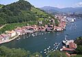
Aerial view of Pasaia and its ria.
-
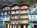
Fishermen's houses in Pasajes de San Juan.
-
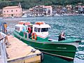
A passenger shallop linking both banks of the ria.
-
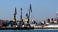
Port facilities.
See also
 In Spanish: Pasajes para niños
