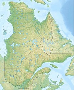
Payne Lake (Quebec) facts for kids
Quick facts for kids Payne LakeTasirruaq |
|
|---|---|
| Lac Payne | |
| Location | Kativik, Quebec, Canada |
| Coordinates | 59°27′N 74°00′W / 59.45°N 74.00°W |
| Primary outflows | Arnaud River |
| Basin countries | Canada |
| Max. length | 103 km (64 mi) |
| Max. width | 12 km (7.5 mi) |
| Surface area | 513 km2 (198 sq mi) |
| Surface elevation | 130 m (430 ft) |
Payne Lake is a large lake located in northern Quebec, Canada. It is found on the Ungava Peninsula, a big piece of land in the far north. This lake is very important because it is the main source of the Arnaud River.
Contents
About Payne Lake
Payne Lake sits at an elevation of about 130 metres (430 ft) (426 feet) above sea level. It stretches for about 103 kilometres (64 mi) (64 miles) long and is 12 kilometres (7.5 mi) (7.5 miles) wide. The lake covers a huge area of 513 square kilometres (198 sq mi) (198 square miles).
How Payne Lake Got Its Name
The lake is named after Frank F. Payne. He was an English-born meteorologist, someone who studies weather. In the 1880s, he explored and worked at a weather station in the Hudson Strait area.
The Inuit people, who are the Indigenous people of the Arctic, have their own name for the lake. They call it Tasirruaq. This name means "the great lake." It was also spelled as Tasurak in the past.
Fish and Wildlife
Payne Lake is a great place for fishing. You can find excellent lake trout here. The lake also has brook trout and landlocked arctic char. Landlocked means they live only in fresh water and do not go to the ocean.
In the region around the lake, you can often see caribou. These large deer-like animals are common in the northern parts of Canada.
Ancient Discoveries at Payne Lake
In 1948, a group of European explorers reached Payne Lake. They found old ruins there. At first, they thought these ruins were from the Dorset culture. The Dorset people were an ancient group who lived in the Arctic long ago.
Who Built the Ruins?
In 1965, a researcher named Thomas E. Lee looked at the ruins again. He suggested that they might have been built by the Norse. The Norse were Vikings who explored North America a very long time ago, before Christopher Columbus.
However, other archaeologists, who are scientists who study ancient cultures, disagreed with Lee. They believed that the ruins were more likely from the Dorset culture. They found that other sites Lee thought were Norse were actually Dorset.
The evidence from Payne Lake is still a bit of a mystery. Some experts say the ruins could be from either the Norse or the Inuit. Others say the ruins do not match what we know about Norse settlements. The structures at Payne Lake are also different from the Dorset longhouses found along the Ungava coast. This means it is hard to say for sure if the Dorset people built them.
 | Janet Taylor Pickett |
 | Synthia Saint James |
 | Howardena Pindell |
 | Faith Ringgold |


