Ungava Peninsula facts for kids
 |
|
| Area | 252,000 km2 (97,000 mi²) |
|---|---|
| Countries | Canada |
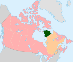
The Ungava Peninsula is a large piece of land in Nunavik, Quebec, Canada. It is like a big finger of land reaching into the water. To its west is Hudson Bay, to the north is Hudson Strait, and to the east is Ungava Bay.
This peninsula is part of the larger Labrador Peninsula. It covers a huge area of about 252,000 square kilometers (97,000 square miles). The very northern tip of the peninsula is called Cape Wolstenholme. This is also the northernmost point in all of Quebec.
The Ungava Peninsula is part of the Canadian Shield, which is a very old and stable part of the Earth's crust. The land here is mostly treeless tundra. It has many rivers and lakes that were formed by glaciers long ago. These rivers and lakes generally flow from east to west.
This area was covered by a thick sheet of ice until about 6,500 years ago. Scientists believe this region was the center from which a massive ice sheet, called the Laurentide Ice Sheet, spread across most of North America during the last ice age.
Contents
Climate
The climate in the Ungava Peninsula is extremely cold. This is because of the Labrador Current, a cold ocean current. This current makes the region much colder in summer than other places at the same latitude.
| Climate data for Kuujjuaq | |||||||||||||
|---|---|---|---|---|---|---|---|---|---|---|---|---|---|
| Month | Jan | Feb | Mar | Apr | May | Jun | Jul | Aug | Sep | Oct | Nov | Dec | Year |
| Record high °C (°F) | 5.6 (42.1) |
7.8 (46.0) |
12.1 (53.8) |
14.7 (58.5) |
31.1 (88.0) |
33.1 (91.6) |
32.2 (90.0) |
30.3 (86.5) |
28.3 (82.9) |
18.3 (64.9) |
10.3 (50.5) |
8.3 (46.9) |
33.1 (91.6) |
| Mean daily maximum °C (°F) | −19.7 (−3.5) |
−18.7 (−1.7) |
−12.9 (8.8) |
−4.1 (24.6) |
4.3 (39.7) |
12.4 (54.3) |
17.1 (62.8) |
15.6 (60.1) |
9.4 (48.9) |
2.2 (36.0) |
−4.9 (23.2) |
−15 (5) |
−1.2 (29.8) |
| Daily mean °C (°F) | −24.3 (−11.7) |
−23.6 (−10.5) |
−18.3 (−0.9) |
−9.1 (15.6) |
0.3 (32.5) |
7.2 (45.0) |
11.5 (52.7) |
10.6 (51.1) |
5.6 (42.1) |
−0.7 (30.7) |
−8.4 (16.9) |
−19.3 (−2.7) |
−5.7 (21.7) |
| Mean daily minimum °C (°F) | −28.8 (−19.8) |
−28.4 (−19.1) |
−23.6 (−10.5) |
−14.1 (6.6) |
−3.8 (25.2) |
2 (36) |
5.8 (42.4) |
5.6 (42.1) |
1.9 (35.4) |
−3.6 (25.5) |
−11.9 (10.6) |
−23.5 (−10.3) |
−10.2 (13.6) |
| Record low °C (°F) | −49.8 (−57.6) |
−43.9 (−47.0) |
−43.9 (−47.0) |
−34.1 (−29.4) |
−24.7 (−12.5) |
−8.3 (17.1) |
−1.6 (29.1) |
−1.7 (28.9) |
−7.8 (18.0) |
−20 (−4) |
−31.1 (−24.0) |
−43.9 (−47.0) |
−49.8 (−57.6) |
| Average precipitation mm (inches) | 33.2 (1.31) |
28.4 (1.12) |
30.7 (1.21) |
27.3 (1.07) |
29.6 (1.17) |
51.5 (2.03) |
59.2 (2.33) |
70.4 (2.77) |
62.1 (2.44) |
51.9 (2.04) |
46.6 (1.83) |
36 (1.4) |
526.8 (20.74) |
| Average rainfall mm (inches) | 0.1 (0.00) |
0.6 (0.02) |
0.6 (0.02) |
2.5 (0.10) |
14.8 (0.58) |
44.8 (1.76) |
59.1 (2.33) |
70.0 (2.76) |
54.1 (2.13) |
25.7 (1.01) |
4.7 (0.19) |
0.4 (0.02) |
277.4 (10.92) |
| Average snowfall cm (inches) | 33.7 (13.3) |
29 (11) |
31.4 (12.4) |
25.3 (10.0) |
14.7 (5.8) |
6.3 (2.5) |
0.1 (0.0) |
0.5 (0.2) |
7.6 (3.0) |
27.5 (10.8) |
43.4 (17.1) |
37.5 (14.8) |
257 (100.9) |
| Source: Meteorological Service of Canada | |||||||||||||
People of Ungava Peninsula
About 10,000 people live on the Ungava Peninsula. Most of them (90%) are Inuit. They live in 12 villages located along the coast.
The largest village is Kuujjuaq. It is the main town of the Kativik Regional Government, which manages the entire peninsula. The islands off the coast of the peninsula are part of the Nunavut Territory.
You can reach this region by air, with flights connecting to southern Quebec. During the warmer months, when the sea ice melts, ships can also bring supplies. Building homes and other structures can be tricky in some areas because of thick permafrost. Permafrost is ground that stays frozen all year round.
Geology and Land Features
The Ungava Peninsula sits on the northeastern part of the Canadian Shield. This area has very old rocks, some formed about 2.7 to 2.9 billion years ago. Younger rocks, formed about 1.8 to 2.1 billion years ago, lie on top of these older rocks.
The peninsula is also home to the Pingualuit crater. This is a large, almost perfectly circular lake that was formed by a meteorite impact thousands of years ago.
Animals of Ungava Peninsula
The Ungava brown bear was a type of grizzly bear that used to live on this peninsula. Sadly, this group of bears is now extinct, meaning they no longer exist.
See also
 In Spanish: Península de Ungava para niños
 | William Lucy |
 | Charles Hayes |
 | Cleveland Robinson |

